참고: 이 데이터 세트는 아직 동료 검토를 거치지 않았습니다. 자세한 내용은 이 GitHub README를 참고하세요.
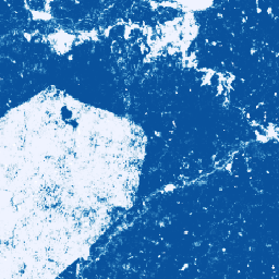
이 이미지 모음은 기본 영역이 상품으로 점유될 픽셀당 확률을 추정하여 제공합니다. 확률 추정치는 10m 해상도로 제공되며 머신러닝 모델에 의해 생성되었습니다. 자세한 내용은 GitHub의 Forest Data Partnership 저장소에 관한 기술 문서를 참고하세요.
이 이미지 컬렉션의 기본 목적은 전 세계 모니터링, 공급망 추적, 복원을 공동으로 개선하여 상품 생산으로 인한 산림 손실을 중단하고 되돌리는 것을 목표로 하는 산림 데이터 파트너십의 사명을 지원하는 것입니다.
이 데이터 세트는 현재 코트디부아르, 가나, 인도네시아, 에콰도르, 페루, 콜롬비아를 포함합니다.
이 커뮤니티 데이터 제품은 커뮤니티에서 더 많은 데이터를 사용할 수 있게 되고 지도를 생성하는 데 사용되는 모델이 지속적으로 개선됨에 따라 시간이 지남에 따라 발전할 수 있습니다. 이 레이어를 개선하기 위한 일반적인 의견이나 추가 데이터 세트를 제공하려면 이 양식을 통해 문의해 주세요.
제한사항: 모델 출력은 2020년과 2023년의 선택한 국가의 연도별 복합으로 제한됩니다. 출력의 일부 영역은 학습 데이터로 잘 표현되지 않습니다. 정확도는 집계되어 보고되며, 지리적 위치와 사용자가 선택한 기준에 따라 달라집니다. 데이터 가용성, 교차 트랙 불균일성 또는 흐림에 기반한 센서 아티팩트가 출력 확률에서 시각적으로 나타날 수 있으며 일부 임계값에서 분류 오류가 발생할 수 있습니다.
이 데이터 세트에는 Earth Engine의 상업적 사용자를 위한 별도의 이용약관이 있습니다. 자세한 내용은 '이용약관' 탭을 참고하세요.
대역
픽셀 크기 10미터
대역
이름
최소
최대
픽셀 크기
설명
probability
0
1
미터
해당 연도에 픽셀에 코코아 나무가 포함될 확률입니다.
이용약관
이용약관
Earth Engine의 비상업적 사용자의 경우 데이터 세트 사용에는 CC-BY 4.0 NC 라이선스가 적용되며 다음 저작자 표시가 필요합니다. 'Produced by Google for the Forest Data Partnership'(Forest Data Partnership을 위해 Google에서 제작)
참고: 이 데이터 세트는 아직 동료 검토를 거치지 않았습니다. 자세한 내용은 이 GitHub README를 참고하세요. 이 이미지 모음은 기본 영역이 상품으로 점유될 픽셀당 확률을 추정하여 제공합니다. 확률 추정치는 10m 해상도로 제공되며 머신러닝 모델에 의해 생성되었습니다. …
[null,null,[],[],[],null,["# Cocoa Probability model 2025a\n\ninfo\n\n\nThis dataset is part of a Publisher Catalog, and not managed by Google Earth Engine.\n\nContact forestdatapartnership@googlegroups.com\n\nfor bugs or [view more datasets](https://developers.google.com/earth-engine/datasets/publisher/forestdatapartnership)\nfrom the Forest Data Partnership Catalog. [Learn more about Publisher datasets](/earth-engine/datasets/publisher). \n[](https://forestdatapartnership.org) \n\nCatalog Owner\n: Forest Data Partnership\n\nDataset Availability\n: 2020-01-01T00:00:00Z--2023-12-31T23:59:59Z\n\nDataset Provider\n:\n\n\n [Produced by Google for the Forest Data Partnership](https://www.forestdatapartnership.org/)\n\nTags\n:\n [agriculture](/earth-engine/datasets/tags/agriculture) [biodiversity](/earth-engine/datasets/tags/biodiversity) [conservation](/earth-engine/datasets/tags/conservation) [crop](/earth-engine/datasets/tags/crop) [eudr](/earth-engine/datasets/tags/eudr) [forestdatapartnership](/earth-engine/datasets/tags/forestdatapartnership) [landuse](/earth-engine/datasets/tags/landuse) [plantation](/earth-engine/datasets/tags/plantation) [pre-review](/earth-engine/datasets/tags/pre-review) [publisher-dataset](/earth-engine/datasets/tags/publisher-dataset) \ncocoa \n\n#### Description\n\n**Note: This dataset is not yet peer-reviewed. Please see this\n[GitHub README](https://github.com/google/forest-data-partnership/tree/main/models)\nfor more information.**\n\nThis image collection provides estimated per-pixel probability that the\nunderlying area is occupied by the commodity. The probability estimates are\nprovided at 10 meter resolution, and have been generated by a machine\nlearning model. For details, see the technical documentation on the\n[Forest Data Partnership repo](https://github.com/google/forest-data-partnership/tree/main)\non Github.\n\nThe primary purpose of this image collection is to support the mission of\nthe [Forest Data Partnership](https://www.forestdatapartnership.org/) which\naims to halt and reverse forest loss from commodity production by\ncollaboratively improving global monitoring, supply chain tracking, and\nrestoration.\n\nThis dataset currently covers the following countries: Côte d'Ivoire, Ghana,\nIndonesia, Ecuador, Peru, Colombia.\n\nThis community data product is meant to evolve over time, as more data\nbecomes available from the community and the model used to produce the maps\ncontinuously improves. If you would like to provide general feedback or\nadditional datasets to improve these layers, please reach out through\n[this form](https://goo.gle/fdap-data).\n\nLimitations: Model output is limited to selected countries as calendar year\ncomposites for 2020 and 2023. Not all regions of the output are well\nrepresented by training data. Accuracy is reported in aggregate, and will\nvary geographically and with user chosen thresholds. Sensor artifacts based\non data availability, cross-track nonuniformity, or cloudiness may be\nvisually apparent in output probabilities and result in classification\nerrors at some thresholds.\n\n**Note that this dataset has separate terms of use for commercial users of\nEarth Engine. Please see \"Terms of Use\" tab for details.**\n\n### Bands\n\n\n**Pixel Size**\n\n10 meters\n\n**Bands**\n\n| Name | Min | Max | Pixel Size | Description |\n|---------------|-----|-----|------------|---------------------------------------------------------------------|\n| `probability` | 0 | 1 | meters | Probability that the pixel includes cocoa trees for the given year. |\n\n### Terms of Use\n\n**Terms of Use**\n\nFor non-commercial users of Earth Engine, use of the dataset is subject to\nCC-BY 4.0 NC license and requires the following attribution:\n\"Produced by Google for the Forest Data Partnership\".\n\nFor commercial use of the dataset you may request access using\n[this form](https://docs.google.com/forms/d/e/1FAIpQLSe7L3eh6t2JIPqEtAQwXwY7ZmW52v8W5vrIi4QN_XYgTNJZLw/viewform?resourcekey=0-db8WFCPwr2AZRhnrnH2SFg).\nAccess will be granted or denied on a case-by-case basis. Commercial use of\nthe dataset is subject to the [Forest Data Partnership Datasets Commercial\nTerms of Use](https://services.google.com/fh/files/misc/forest_data_partnership_datasets_commerical_terms_of_use.pdf).\n\nContains modified Copernicus Sentinel data \\[2015-present\\]. See the\n[Sentinel Data Legal Notice](https://sentinels.copernicus.eu/documents/247904/690755/Sentinel_Data_Legal_Notice).\n\n### Citations\n\nCitations:\n\n- Forest Data Partnership. 2025. Community models 2025a. [Online](https://github.com/google/forest-data-partnership/tree/main/models/README.md)\n\n### Explore with Earth Engine\n\n| **Important:** Earth Engine is a platform for petabyte-scale scientific analysis and visualization of geospatial datasets, both for public benefit and for business and government users. Earth Engine is free to use for research, education, and nonprofit use. To get started, please [register for Earth Engine access.](https://console.cloud.google.com/earth-engine)\n\n### Code Editor (JavaScript)\n\n```javascript\nMap.setCenter(-7.67, 6.71, 11);\n\nvar collection = ee.ImageCollection(\n 'projects/forestdatapartnership/assets/cocoa/model_2025a');\n\nvar cocoa2020 = collection.filterDate('2020-01-01', '2020-12-31').mosaic();\nMap.addLayer(\n cocoa2020.selfMask(), {min: 0.5, max: 1, palette: 'white,blue'}, 'cocoa 2020');\n\nvar cocoa2023 = collection.filterDate('2023-01-01', '2023-12-31').mosaic();\nMap.addLayer(\n cocoa2023.selfMask(), {min: 0.5, max: 1, palette: 'white,green'}, 'cocoa 2023');\n```\n[Open in Code Editor](https://code.earthengine.google.com/?scriptPath=Examples:Datasets/forestdatapartnership/projects_forestdatapartnership_assets_cocoa_model_2025a) \n[Cocoa Probability model 2025a](/earth-engine/datasets/catalog/projects_forestdatapartnership_assets_cocoa_model_2025a) \nNote: This dataset is not yet peer-reviewed. Please see this GitHub README for more information. This image collection provides estimated per-pixel probability that the underlying area is occupied by the commodity. The probability estimates are provided at 10 meter resolution, and have been generated by a machine learning model. For ... \nprojects/forestdatapartnership/assets/cocoa/model_2025a, agriculture,biodiversity,conservation,crop,eudr,forestdatapartnership,landuse,plantation,pre-review,publisher-dataset \n2020-01-01T00:00:00Z/2023-12-31T23:59:59Z \n-90 -180 90 180 \nGoogle Earth Engine \nhttps://developers.google.com/earth-engine/datasets\n\n- [](https://doi.org/https://www.forestdatapartnership.org/)\n- [](https://doi.org/https://developers.google.com/earth-engine/datasets/catalog/projects_forestdatapartnership_assets_cocoa_model_2025a)"]]