কোকো সম্ভাব্যতা মডেল ২০২৫ক 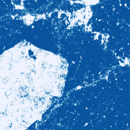
**দ্রষ্টব্য: এই ডেটাসেটটি এখনও পিয়ার-রিভিউ করা হয়নি। আরও তথ্যের জন্য অনুগ্রহ করে এই গিটহাব README দেখুন।** এই চিত্র সংগ্রহটি প্রতি-পিক্সেল ভিত্তিতে একটি আনুমানিক সম্ভাবনা প্রদান করে যে, অন্তর্নিহিত এলাকাটি পণ্য দ্বারা অধিকৃত। সম্ভাবনার এই অনুমানগুলি ১০ মিটার রেজোলিউশনে প্রদান করা হয়েছে এবং তৈরি করা হয়েছে … কৃষি জীববৈচিত্র্য কোকো সংরক্ষণ ফসল ইইউডিআর কোকো সম্ভাব্যতা মডেল 2025b 
এই ডেটাসেটের প্রযুক্তিগত ডকুমেন্টেশনের জন্য অনুগ্রহ করে এই গিটহাব README দেখুন। এই চিত্র সংগ্রহটি প্রতি-পিক্সেল ভিত্তিতে একটি আনুমানিক সম্ভাবনা প্রদান করে যে, অন্তর্নিহিত এলাকাটি পণ্য দ্বারা অধিকৃত। সম্ভাবনার এই অনুমানগুলো ১০ মিটার রেজোলিউশনে প্রদান করা হয়েছে এবং একটি মেশিন লার্নিং মডেল দ্বারা তৈরি করা হয়েছে। … কৃষি জীববৈচিত্র্য কোকো সংরক্ষণ ফসল ইইউডিআর কফি সম্ভাব্যতা মডেল 2025a 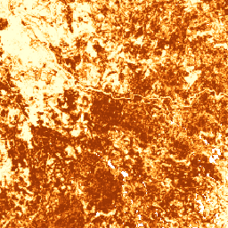
**দ্রষ্টব্য: এই ডেটাসেটটি এখনও পিয়ার-রিভিউ করা হয়নি। আরও তথ্যের জন্য অনুগ্রহ করে এই গিটহাব README দেখুন।** এই চিত্র সংগ্রহটি প্রতি-পিক্সেল ভিত্তিতে একটি আনুমানিক সম্ভাবনা প্রদান করে যে, অন্তর্নিহিত এলাকাটি পণ্য দ্বারা অধিকৃত। সম্ভাবনার এই অনুমানগুলি ১০ মিটার রেজোলিউশনে প্রদান করা হয়েছে এবং তৈরি করা হয়েছে … কৃষি জীববৈচিত্র্য কফি সংরক্ষণ ফসল ইইউডিআর কফি সম্ভাব্যতা মডেল 2025b 
এই ডেটাসেটের প্রযুক্তিগত ডকুমেন্টেশনের জন্য অনুগ্রহ করে এই গিটহাব README দেখুন। এই চিত্র সংগ্রহটি প্রতি-পিক্সেল ভিত্তিতে একটি আনুমানিক সম্ভাবনা প্রদান করে যে, অন্তর্নিহিত এলাকাটি পণ্য দ্বারা অধিকৃত। সম্ভাবনার এই অনুমানগুলো ১০ মিটার রেজোলিউশনে প্রদান করা হয়েছে এবং একটি মেশিন লার্নিং মডেল দ্বারা তৈরি করা হয়েছে। … কৃষি জীববৈচিত্র্য কফি সংরক্ষণ ফসল ইইউডিআর পাম তেল বাগানের বিশ্ব মানচিত্র 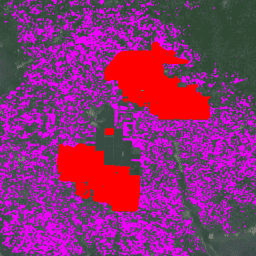
ডেটাসেটটি হলো ২০১৯ সালের একটি ১০ মিটার বৈশ্বিক শিল্প ও ক্ষুদ্র চাষি পাম তেল মানচিত্র। এটি সেইসব এলাকাকে অন্তর্ভুক্ত করে যেখানে পাম তেল বাগান শনাক্ত করা হয়েছে। শ্রেণীবদ্ধ ছবিগুলো সেন্টিনেল-১ এবং সেন্টিনেল-২ এর অর্ধ-বার্ষিক কম্পোজিটের উপর ভিত্তি করে একটি কনভল্যুশনাল নিউরাল নেটওয়ার্কের আউটপুট। অতিরিক্ত তথ্যের জন্য নিবন্ধটি দেখুন… কৃষি জীববৈচিত্র্য সংরক্ষণ ফসল বৈশ্বিক ভূমি ব্যবহার পাম সম্ভাব্যতা মডেল 2025a 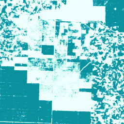
**দ্রষ্টব্য: এই ডেটাসেটটি এখনও পিয়ার-রিভিউ করা হয়নি। আরও তথ্যের জন্য অনুগ্রহ করে এই গিটহাব README দেখুন।** এই চিত্র সংগ্রহটি প্রতি-পিক্সেল ভিত্তিতে একটি আনুমানিক সম্ভাবনা প্রদান করে যে, অন্তর্নিহিত এলাকাটি পণ্য দ্বারা অধিকৃত। সম্ভাবনার এই অনুমানগুলি ১০ মিটার রেজোলিউশনে প্রদান করা হয়েছে এবং তৈরি করা হয়েছে … কৃষি জীববৈচিত্র্য সংরক্ষণ ফসল ইইউডিআর বন তথ্য অংশীদারিত্ব পাম সম্ভাব্যতা মডেল 2025b 
এই ডেটাসেটের প্রযুক্তিগত ডকুমেন্টেশনের জন্য অনুগ্রহ করে এই গিটহাব README দেখুন। এই চিত্র সংগ্রহটি প্রতি-পিক্সেল ভিত্তিতে একটি আনুমানিক সম্ভাবনা প্রদান করে যে, অন্তর্নিহিত এলাকাটি পণ্য দ্বারা অধিকৃত। সম্ভাবনার এই অনুমানগুলো ১০ মিটার রেজোলিউশনে প্রদান করা হয়েছে এবং একটি মেশিন লার্নিং মডেল দ্বারা তৈরি করা হয়েছে। … কৃষি জীববৈচিত্র্য সংরক্ষণ ফসল ইইউডিআর বন তথ্য অংশীদারিত্ব রাবার সম্ভাব্যতা মডেল 2025b 
এই ডেটাসেটের প্রযুক্তিগত ডকুমেন্টেশনের জন্য অনুগ্রহ করে এই গিটহাব README দেখুন। এই চিত্র সংগ্রহটি প্রতি-পিক্সেল ভিত্তিতে একটি আনুমানিক সম্ভাবনা প্রদান করে যে, অন্তর্নিহিত এলাকাটি পণ্য দ্বারা অধিকৃত। সম্ভাবনার এই অনুমানগুলো ১০ মিটার রেজোলিউশনে প্রদান করা হয়েছে এবং একটি মেশিন লার্নিং মডেল দ্বারা তৈরি করা হয়েছে। … কৃষি জীববৈচিত্র্য সংরক্ষণ ফসল ইইউডিআর বন তথ্য অংশীদারিত্ব রাবার গাছের সম্ভাব্যতা মডেল ২০২৫ক 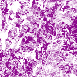
**দ্রষ্টব্য: এই ডেটাসেটটি এখনও পিয়ার-রিভিউ করা হয়নি। আরও তথ্যের জন্য অনুগ্রহ করে এই গিটহাব README দেখুন।** এই চিত্র সংগ্রহটি প্রতি-পিক্সেল ভিত্তিতে একটি আনুমানিক সম্ভাবনা প্রদান করে যে, অন্তর্নিহিত এলাকাটি পণ্য দ্বারা অধিকৃত। সম্ভাবনার এই অনুমানগুলি ১০ মিটার রেজোলিউশনে প্রদান করা হয়েছে এবং তৈরি করা হয়েছে … কৃষি জীববৈচিত্র্য সংরক্ষণ ফসল ইইউডিআর বন তথ্য অংশীদারিত্ব
Datasets tagged plantation in Earth Engine
[null,null,[],[],["The information describes four datasets related to agricultural land use. The first is a 2019 global map of oil palm plantations at 10m resolution, created using a neural network on satellite imagery. The other three are per-pixel probability models, also at 10m resolution, for cocoa, palm, and rubber trees respectively, all labeled as \"2024a\" and not peer-reviewed. These models estimate the probability of each area being occupied by these specific crops. All datasets are tagged with biodiversity, conservation, crop, and landuse.\n"]]