২০০০ গ্রিনল্যান্ড মোজাইক - গ্রিনল্যান্ড বরফ মানচিত্রায়ন প্রকল্প (জিআইএমপি) 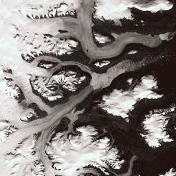
এই ডেটাসেটটি ১৯৯৯ থেকে ২০০২ সাল পর্যন্ত ল্যান্ডস্যাট ৭ ইটিএম+ এবং রাডারস্যাট-১ এসএআর চিত্র থেকে প্রাপ্ত গ্রিনল্যান্ড আইস শিটের একটি সম্পূর্ণ ১৫ মিটার রেজোলিউশনের চিত্র মোজাইক প্রদান করে। এই পদ্ধতিগুলোর মধ্যে রয়েছে ইমেজ ক্লাউড মাস্কিং, প্যান শার্পেনিং, ইমেজ স্যাম্পলিং এবং রিসাইজিং-এর সমন্বয়, … আর্কটিক গিম্প গ্রিনল্যান্ড চিত্রাবলী নাসা মেরু ক্রায়োস্যাট-২ অ্যান্টার্কটিকা ১কিমি ডিইএম 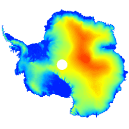
এই ডেটাসেটটি হলো অ্যান্টার্কটিক বরফ চাদর এবং বরফ তাকগুলির একটি ডিজিটাল উচ্চতা মডেল (ডিইএম), যা জুলাই ২০১০ থেকে জুলাই ২০১৬-এর মধ্যে ক্রায়োস্যাট-২ স্যাটেলাইটের রাডার অল্টিমিটার দ্বারা রেকর্ড করা পর্যবেক্ষণের উপর ভিত্তি করে তৈরি। ডিইএমটি ১, … এর মধ্যে সংগৃহীত উচ্চতা পরিমাপের স্থান-কালিক ফিট থেকে গঠিত হয়েছে। অ্যান্টার্কটিকা ডেম উচ্চতা উচ্চতা-ভূসংস্থান মেরু গ্রিনল্যান্ড ডিইএম - গ্রিনল্যান্ড ম্যাপিং প্রজেক্ট (জিআইএমপি) 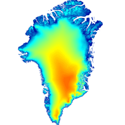
এই ডিজিটাল উচ্চতা মডেল (DEM) প্রায় ৮২.৫° উত্তর অক্ষাংশের দক্ষিণে বরফ চাদরের পরিধি ও প্রান্তের (অর্থাৎ ভারসাম্য রেখার উচ্চতার নীচের অংশ) জন্য ASTER এবং SPOT-5 DEM-এর সমন্বয়ে এবং বরফ চাদরের অভ্যন্তরভাগ ও সুদূর উত্তরে AVHRR ফোটোক্লিনোমেট্রির (স্ক্যাম্বোস এবং …) মাধ্যমে নির্মিত হয়েছে। আর্কটিক উচ্চতা-ভূসংস্থান জিম্প গ্রিনল্যান্ড নাসা মেরু গ্রিনল্যান্ড বরফ ও মহাসাগর মাস্ক - গ্রিনল্যান্ড ম্যাপিং প্রজেক্ট (GIMP) 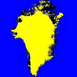
এই ডেটাসেটটি গ্রিনল্যান্ড আইস শিটের জন্য ১৫ মিটার গভীরতায় সম্পূর্ণ স্থল বরফ এবং মহাসাগরীয় শ্রেণিবিন্যাস মাস্ক প্রদান করে। বরফের আচ্ছাদন ম্যাপ করা হয়েছে ইউএসজিএস (USGS) দ্বারা বিতরণকৃত ল্যান্ডস্যাট ৭ এনহ্যান্সড থিমেটিক ম্যাপার প্লাস (ETM+) থেকে প্রাপ্ত অর্থোরেটিফাইড প্যানক্রোম্যাটিক (ব্যান্ড ৮) চিত্রাবলীর সংমিশ্রণে, এবং… আর্কটিক ক্রায়োস্ফিয়ার গিম্প গ্রিনল্যান্ড বরফ নাসা MEaSUREs গ্রিনল্যান্ড বরফের বেগ: অপটিক্যাল চিত্র থেকে নির্বাচিত হিমবাহ স্থানের বেগ মানচিত্র সংস্করণ ২ 
এই ডেটাসেটটি, যা নাসার ‘মেকিং আর্থ সিস্টেম ডেটা রেকর্ডস ফর ইউজ ইন রিসার্চ এনভায়রনমেন্টস (MEaSUREs)’ প্রোগ্রামের একটি অংশ, নির্বাচিত হিমবাহের বহির্গমন অঞ্চলের গড় মাসিক বেগের মানচিত্র নিয়ে গঠিত। ল্যান্ডস্যাট দ্বারা সংগৃহীত অপটিক্যাল চিত্রজোড়ার মধ্যে দৃশ্যমান বৈশিষ্ট্যগুলো ট্র্যাক করার মাধ্যমে এই মানচিত্রগুলো তৈরি করা হয়… আর্কটিক ক্রায়োস্ফিয়ার গিম্প গ্রিনল্যান্ড বরফ নাসা
Datasets tagged polar in Earth Engine
[null,null,[],[],[]]