GHSL: বৈশ্বিক বসতি বৈশিষ্ট্য (১০ মি) ২০১৮ (P2023A) 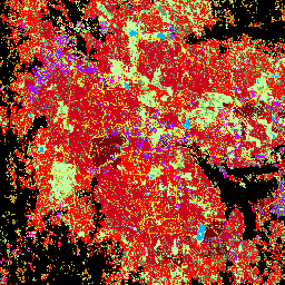
এই স্থানিক রাস্টার ডেটাসেটটি ১০ মিটার রেজোলিউশনে মানব বসতিগুলিকে চিত্রিত করে এবং নির্মিত পরিবেশের কার্যকরী এবং উচ্চতা-সম্পর্কিত উপাদানগুলির পরিপ্রেক্ষিতে তাদের অভ্যন্তরীণ বৈশিষ্ট্যগুলি বর্ণনা করে। GHSL ডেটা পণ্য সম্পর্কে আরও তথ্য GHSL ডেটা প্যাকেজ ২০২৩ রিপোর্টে পাওয়া যাবে … ভবন নির্মিত বিল্টআপ কোপারনিকাস জিএইচএসএল উচ্চতা টাইগার: মার্কিন আদমশুমারি সড়ক 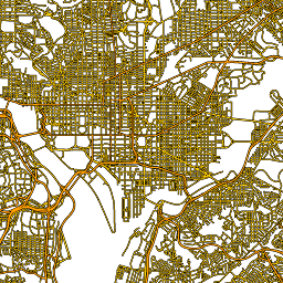
এই মার্কিন যুক্তরাষ্ট্রের আদমশুমারি ব্যুরো TIGER ডেটাসেটে ২০১৬ সালের প্রকাশনা থেকে সমস্ত রাস্তার অংশ রয়েছে, যার মধ্যে মার্কিন যুক্তরাষ্ট্র, কলম্বিয়া জেলা, পুয়ের্তো রিকো এবং দ্বীপ অঞ্চলগুলিকে কভার করে ১ কোটি ৯০ লক্ষেরও বেশি পৃথক লাইন বৈশিষ্ট্য রয়েছে। প্রতিটি বৈশিষ্ট্য একটি রাস্তার অংশের জ্যামিতি উপস্থাপন করে (একটি … আদমশুমারি অবকাঠামো-সীমানা সড়ক টেবিল টাইগার মার্কিন
Datasets tagged roads in Earth Engine
[null,null,[],[],["The content describes two spatial datasets. The first, GHSL, delineates human settlements at 10m resolution, detailing functional and height-related aspects of the built environment. The second, TIGER, from the US Census Bureau, contains over 19 million road segments from the 2016 release, covering the US, District of Columbia, Puerto Rico, and Island Areas, each represented by a road segment geometry.\n"]]