জিএইচএসএল: গ্লোবাল বিল্ডিং হাইট ২০১৮ (পি২০২৩এ) 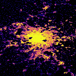
এই স্থানিক রাস্টার ডেটাসেটটি ২০১৮ সালের সাপেক্ষে ১০০ মিটার রেজোলিউশনে ভবনের উচ্চতার বৈশ্বিক বন্টন চিত্রিত করে। ভবনের উচ্চতা পূর্বাভাসের জন্য ব্যবহৃত ইনপুট ডেটাগুলো হলো ALOS গ্লোবাল ডিজিটাল সারফেস মডেল (৩০ মিটার), নাসা শাটল রাডার টপোগ্রাফিক মিশন… এছাড়াও ভবন নির্মিত নির্মিত-পরিবেশ নির্মিত কোপার্নিকাস জিএইচএসএল: গ্লোবাল বিল্ট-আপ সারফেস ১০মি (পি২০২৩এ) 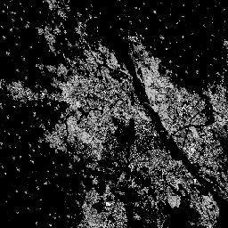
এই রাস্টার ডেটাসেটটি S2 ইমেজ ডেটা থেকে প্রাপ্ত তথ্যের ভিত্তিতে ২০১৮ সালের জন্য নির্মিত পৃষ্ঠের বন্টন চিত্রিত করে, যা প্রতি ১০ মিটার গ্রিড সেলে বর্গমিটারে প্রকাশ করা হয়েছে। ডেটাসেটগুলো পরিমাপ করে: ক) মোট নির্মিত পৃষ্ঠ, এবং খ) … এর গ্রিড সেলগুলোতে বরাদ্দকৃত নির্মিত পৃষ্ঠ। নির্মিত নির্মিত-পরিবেশ নির্মিতআপ কোপারনিকাস জিএইচএসএল জেআরসি জিএইচএসএল: বৈশ্বিক নির্মিত পৃষ্ঠতল ১৯৭৫-২০৩০ (পি২০২৩এ) 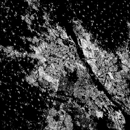
এই রাস্টার ডেটাসেটটি নির্মিত পৃষ্ঠের বন্টন চিত্রিত করে, যা প্রতি ১০০ মিটার গ্রিড সেলে বর্গমিটারে প্রকাশ করা হয়েছে। ডেটাসেটটি পরিমাপ করে: ক) মোট নির্মিত পৃষ্ঠ, এবং খ) প্রধানত অনাবাসিক (NRES) ব্যবহারের গ্রিড সেলগুলিতে বরাদ্দকৃত নির্মিত পৃষ্ঠ। ডেটা স্থানিক-কালিকভাবে ইন্টারপোলেট করা হয়েছে অথবা… নির্মিত নির্মিত-পরিবেশ নির্মিতআপ কোপারনিকাস জিএইচএসএল জেআরসি জিএইচএসএল: বৈশ্বিক বসতির বৈশিষ্ট্য (১০ মি) ২০১৮ (পি২০২৩এ) 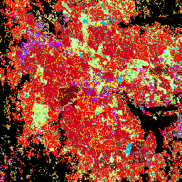
এই স্থানিক রাস্টার ডেটাসেটটি ১০ মিটার রেজোলিউশনে মানব বসতিগুলোকে চিহ্নিত করে এবং নির্মিত পরিবেশের কার্যকরী ও উচ্চতা-সম্পর্কিত উপাদানগুলোর পরিপ্রেক্ষিতে তাদের অভ্যন্তরীণ বৈশিষ্ট্য বর্ণনা করে। GHSL ডেটা প্রোডাক্টগুলো সম্পর্কে আরও তথ্য GHSL ডেটা প্যাকেজ ২০২৩ প্রতিবেদনে পাওয়া যাবে… বিল্ডিং নির্মিত নির্মিত এলাকা কোপারনিকাস জিএইচএসএল উচ্চতা সিংহুয়া ফ্রম-জিএলসি অভেদ্য পৃষ্ঠে পরিবর্তনের বছর 
এই ডেটাসেটটিতে ১৯৮৫ থেকে ২০১৮ সাল পর্যন্ত ৩০ মিটার রেজোলিউশনে বৈশ্বিক অপ্রবেশ্য পৃষ্ঠতলের বার্ষিক পরিবর্তনের তথ্য রয়েছে। সুপারভাইজড ক্লাসিফিকেশন এবং টেম্পোরাল কনসিস্টেন্সি চেকিং-এর একটি সম্মিলিত পদ্ধতির মাধ্যমে প্রবেশ্য থেকে অপ্রবেশ্যে পরিবর্তন নির্ধারণ করা হয়েছে। ৫০% এর বেশি অপ্রবেশ্য পিক্সেলকে অপ্রবেশ্য হিসেবে সংজ্ঞায়িত করা হয়েছে। … সিংহুয়া শহুরে নির্মিত জনসংখ্যা
Datasets tagged built in Earth Engine
[null,null,[],[],[]]