-
GHSL: 전 세계 정착지 특성 (10m) 2018 (P2023A)
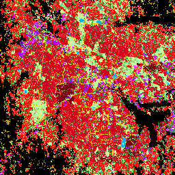
이 공간 래스터 데이터 세트는 10m 해상도로 인적 거주지를 나타내며, 건축 환경의 기능 및 높이 관련 구성요소 측면에서 내부 특성을 설명합니다. GHSL 데이터 제품에 대한 자세한 내용은 GHSL 데이터 패키지 2023 보고서에서 확인할 수 있습니다. building built builtup copernicus ghsl height -
TIGER: 미국 인구조사 도로

이 미국 인구조사국 TIGER 데이터 세트에는 2016년 출시의 모든 도로 구간이 포함되어 있으며, 미국, 워싱턴 DC, 푸에르토리코, 섬 지역을 포함하는 1,900만 개 이상의 개별 선 피처가 포함되어 있습니다. 각 기능은 도로 세그먼트 형상(… census infrastructure-boundaries roads table tiger us
Datasets tagged roads in Earth Engine
[null,null,[],[],["The content describes two spatial datasets. The first, GHSL, delineates human settlements at 10m resolution, detailing functional and height-related aspects of the built environment. The second, TIGER, from the US Census Bureau, contains over 19 million road segments from the 2016 release, covering the US, District of Columbia, Puerto Rico, and Island Areas, each represented by a road segment geometry.\n"]]