-
Allen Coral Atlas (ACA) - Geomorphic Zonation and Benthic Habitat - v2.0
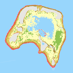
Allen Coral Atlas 数据集以 5 米的像素分辨率绘制了世界浅水珊瑚礁的地球形态分区和底栖栖息地。此外,该数据集还包含一个全球珊瑚礁范围产品,用于绘制无法明确纳入地球形态和… 的其他珊瑚礁区域 海洋 sentinel2-derived -
Cloud Score+ S2_HARMONIZED V1

Cloud Score+ 是一款质量评估 (QA) 处理器,适用于中高分辨率的光学卫星图像。Cloud Score+ S2_HARMONIZED 数据集正基于协调版 Sentinel-2 L1C 集合进行业务化生产,Cloud Score+ 输出可用于识别相对清晰的像素点,并有效去除云层… 云 google satellite-imagery sentinel2-derived -
Dynamic Surface Water Extent from Harmonized Landsat Sentinel-2 (DSWx-HLS) V1

此数据集包含第 3 级动态 OPERA 地表水范围产品版本 1。这些数据是经过验证的地表水范围观测结果,从 2023 年 4 月开始提供。产品文档中介绍了已知问题和使用注意事项。用于生成每个产品的输入数据集是协调版… geophysical landsat-derived nasa opera sentinel2-derived surface -
Dynamic World V1

Dynamic World 是一个分辨率为 10 米的近乎实时 (NRT) 土地使用/土地覆盖 (LULC) 数据集,其中包含九个类别的类别概率和标签信息。Dynamic World 预测数据覆盖从 2015 年 6 月 27 日至今的 Sentinel-2 L1C 数据集。Sentinel-2 的重访频率为 2-5 天… global google landcover landuse landuse-landcover nrt -
ESA WorldCereal 10 m v100

欧洲航天局 (ESA) WorldCereal 10 m 2021 产品套件包含全球范围的年度和季节性农作物地图及其相关置信度。这些地图是作为 ESA-WorldCereal 项目的一部分生成的。如需详细了解这些产品的内容以及所用的方法… agriculture copernicus crop esa global landcover -
ESA WorldCereal Active Cropland 10 m v100

欧洲航天局 (ESA) WorldCereal Active Cropland 10 m 2021 产品套件包含全球范围的季节性活跃农田标记。这些标记是作为 ESA-WorldCereal 项目的一部分生成的。活跃农田产品用于指示被识别为临时农作物的像素是否已积极… agriculture copernicus crop esa global landcover -
ESA WorldCover 10m v100
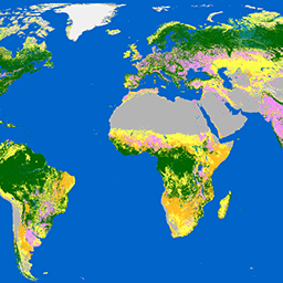
欧洲航天局 (ESA) WorldCover 10 m 2020 产品基于 Sentinel-1 和 Sentinel-2 数据,以 10 米的分辨率提供 2020 年的全球土地覆盖地图。WorldCover 产品包含 11 种土地覆盖类别,是在… 框架下生成的 esa landcover landuse landuse-landcover sentinel1-derived sentinel2-derived -
ESA WorldCover 10m v200

欧洲航天局 (ESA) WorldCover 10 m 2021 产品基于 Sentinel-1 和 Sentinel-2 数据,以 10 米的分辨率提供 2021 年的全球土地覆盖地图。WorldCover 产品包含 11 种土地覆盖类别,是在… 框架下生成的 esa landcover landuse landuse-landcover sentinel1-derived sentinel2-derived -
GHSL:2018 年全球建筑高度 (P2023A)

此空间栅格数据集以 100 米的分辨率描绘了 2018 年的全球建筑高度分布情况。用于预测建筑高度的输入数据包括 ALOS 全球数字地表模型 (30 米)、NASA 航天飞机雷达地形测绘任务… alos building built built-environment builtup copernicus -
GHSL:1975-2030 年全球建筑体积 (P2023A)

此栅格数据集描绘了全球建筑体积分布情况,以每 100 米网格单元的立方米数表示。该数据集测量了总建筑体积以及分配给以非住宅 (NRES) 为主的网格单元的建筑体积。估算值基于建成区… alos building built-environment copernicus dem ghsl -
GHSL:全球建成区地表 10 米 (P2023A)

此栅格数据集描绘了 2018 年的建成区地表分布情况,以每 10 米网格单元的平方米数表示,数据来自 S2 图像。该数据集测量了:a) 总建成区地表,以及 b) 分配给… 的网格单元的建成区地表 built built-environment builtup copernicus ghsl jrc -
GHSL:1975-2030 年全球建成区地表 (P2023A)
此栅格数据集描绘了建成区地表分布情况,以每 100 米网格单元的平方米数表示。该数据集测量了:a) 总建成区地表,以及 b) 分配给以非住宅 (NRES) 为主的网格单元的建成区地表。数据经过空间-时间插值或… built built-environment builtup copernicus ghsl jrc -
GHSL:全球居住地特征 (10 米) 2018 年 (P2023A)
此空间栅格数据集以 10 米的分辨率描绘了人类居住地,并根据建成环境的功能和高度相关组件描述了其内部特征。如需详细了解 GHSL 数据产品,请参阅 GHSL Data Package 2023 报告… building built builtup copernicus ghsl height -
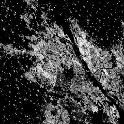
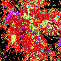
Satellite Embedding V1
Google Satellite Embedding 数据集是一个全球性的、可用于分析的已学习地理空间嵌入集合。此数据集中的每个 10 米像素都是一个 64 维表示形式,或“嵌入向量”,用于编码该像素及其周围区域的地表状况的时间轨迹,这些轨迹由各种地球观测… annual global google landsat-derived satellite-imagery sentinel1-derived
Datasets tagged sentinel2-derived in Earth Engine
[null,null,[],[],[]]