-
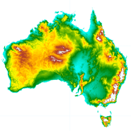
DEM-H:澳大利亚 SRTM 水文强制数字高程模型

水文强制数字高程模型 (DEM-H) 源自 NASA 于 2000 年 2 月获取的 SRTM 数据。模型已进行水文条件调整和排水强制处理。DEM-H 基于 SRTM 高程和已映射的河流线捕获水流路径,并支持划定… 澳大利亚 dem elevation elevation-topography ga geophysical -
DEM-S:澳大利亚平滑数字高程模型
平滑数字高程模型 (DEM-S) 源自 NASA 于 2000 年 2 月获取的 SRTM 数据。DEM-S 表示地面地形(不包括植被特征),并且经过平滑处理,以减少噪声并改进地表形状的表示。一种自适应流程,应用了更多… 澳大利亚 dem elevation elevation-topography ga geophysical -
GHSL:全球建筑物高度 2018 年(P2023A)

此空间栅格数据集描绘了 2018 年全球建筑物高度分布情况,分辨率为 100 米。用于预测建筑物高度的输入数据包括 ALOS 全球数字地表模型 (30 m)、NASA 航天飞机雷达地形任务 … alos building built built-environment builtup copernicus -
GHSL:全球建筑体积 1975-2030 年 (P2023A)

此栅格数据集描绘了建筑物体积的全球分布情况,以每 100 米网格单元的立方米数表示。该数据集用于衡量总建筑体积以及分配给主要为非住宅 (NRES) 用途的网格单元的建筑体积。估算值基于累积的… alos building built-environment copernicus dem ghsl -
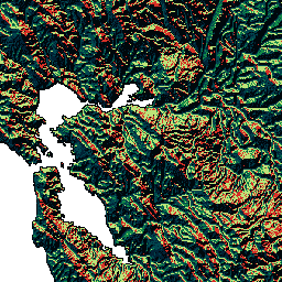
GMTED2010:2010 年全球多分辨率地形高程数据

全球多分辨率地形高程数据 2010 (GMTED2010) 数据集包含全球高程数据,这些数据以 7.5 角秒的分辨率从各种来源收集而来。如需了解详情,请参阅数据集报告。GMTED2010 的主要源数据集是 NGA 的 SRTM 数字地形高程数据 (DTED®,… dem elevation elevation-topography geophysical srtm topography -
MOD44W.005 基于 MODIS 和 SRTM 派生的陆地水体掩码

全球水体掩膜使用 SWBD(SRTM 水体数据)与 MODIS 250 米数据相结合,创建了一张完整的全球地表水地图,空间分辨率为 250 米,时间约为 2000-2002 年。此数据集旨在用于处理栅格数据,并用于… 地球物理 mod44w modis srtm 地表地下水 水掩膜 -
MOD44W.006 Terra Land Water Mask Derived From MODIS and SRTM Yearly Global 250m

MOD44W V6 陆地/水体掩码 250 米产品是使用经过 MODIS 数据训练并经过 MOD44W V5 产品验证的决策树分类器得出的。应用了一系列掩码来解决地形阴影、烧伤痕迹、多云或冰盖等造成的已知问题… 地球物理 mod44w modis nasa srtm 地表-地下水 -
NASA SRTM 数字高程 30 米
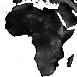
航天飞机雷达地形测绘任务 (SRTM,参见 Farr 等人,2007 年) 数字高程数据是一项国际研究项目,旨在获取近乎全球范围的数字高程模型。此 SRTM V3 产品 (SRTM Plus) 由 NASA JPL 提供,分辨率为 1 角秒… dem 海拔 海拔-地形 地球物理 nasa srtm -
NASADEM:NASA 30 米数字高程模型
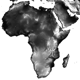
NASADEM 是对 SRTM 数据的重新处理,通过纳入来自 ASTER GDEM、ICESat GLAS 和 PRISM 数据集的辅助数据,提高了准确性。最重要的处理改进包括通过改进的相位解包裹来减少空隙,以及使用 ICESat GLAS 数据进行控制。文档:用户指南 dem 海拔 海拔-地形 地球物理 nasa srtm -
SRTM 数字高程数据版本 4

航天飞机雷达地形测绘任务 (SRTM) 数字高程数据集最初的目的是提供近乎全球范围内一致的高质量高程数据。此版本的 SRTM 数字高程数据经过处理,可填补数据空白,并提高易用性。 dem elevation elevation-topography geophysical srtm topography -
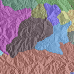
WWF HydroATLAS 流域级别 03

BasinATLAS 是 HydroATLAS 数据库的一个组成部分,而 HydroATLAS 数据库是 HydroSHEDS 的一个组成部分。BasinATLAS 以高空间分辨率为世界上的所有流域提供标准化的水文环境属性信息汇编。此数据集包含 56 个变量的数据,分为 281 个属性和… 地球物理 hydroatlas 水文地理 水文 hydrosheds srtm -
WWF HydroATLAS 流域级别 04

BasinATLAS 是 HydroATLAS 数据库的一个组成部分,而 HydroATLAS 数据库是 HydroSHEDS 的一个组成部分。BasinATLAS 以高空间分辨率为世界上的所有流域提供标准化的水文环境属性信息汇编。此数据集包含 56 个变量的数据,分为 281 个属性和… 地球物理 hydroatlas 水文地理 水文 hydrosheds srtm -
WWF HydroATLAS 盆地级别 05

BasinATLAS 是 HydroATLAS 数据库的一个组成部分,而 HydroATLAS 数据库是 HydroSHEDS 的一个组成部分。BasinATLAS 以高空间分辨率为世界上的所有流域提供标准化的水文环境属性信息汇编。此数据集包含 56 个变量的数据,分为 281 个属性和… 地球物理 hydroatlas 水文地理 水文 hydrosheds srtm -
WWF HydroATLAS 流域级别 06
BasinATLAS 是 HydroATLAS 数据库的一个组成部分,而 HydroATLAS 数据库是 HydroSHEDS 的一个组成部分。BasinATLAS 以高空间分辨率为世界上的所有流域提供标准化的水文环境属性信息汇编。此数据集包含 56 个变量的数据,分为 281 个属性和… 地球物理 hydroatlas 水文地理 水文 hydrosheds srtm -
WWF HydroATLAS 流域级别 07
BasinATLAS 是 HydroATLAS 数据库的一个组成部分,而 HydroATLAS 数据库是 HydroSHEDS 的一个组成部分。BasinATLAS 以高空间分辨率为世界上的所有流域提供标准化的水文环境属性信息汇编。此数据集包含 56 个变量的数据,分为 281 个属性和… 地球物理 hydroatlas 水文地理 水文 hydrosheds srtm -
WWF HydroATLAS 流域级别 08

BasinATLAS 是 HydroATLAS 数据库的一个组成部分,而 HydroATLAS 数据库是 HydroSHEDS 的一个组成部分。BasinATLAS 以高空间分辨率为世界上的所有流域提供标准化的水文环境属性信息汇编。此数据集包含 56 个变量的数据,分为 281 个属性和… 地球物理 hydroatlas 水文地理 水文 hydrosheds srtm -
WWF HydroATLAS 流域级别 09

BasinATLAS 是 HydroATLAS 数据库的一个组成部分,而 HydroATLAS 数据库是 HydroSHEDS 的一个组成部分。BasinATLAS 以高空间分辨率为世界上的所有流域提供标准化的水文环境属性信息汇编。此数据集包含 56 个变量的数据,分为 281 个属性和… 地球物理 hydroatlas 水文地理 水文 hydrosheds srtm -
WWF HydroATLAS 流域级别 10
BasinATLAS 是 HydroATLAS 数据库的一个组成部分,而 HydroATLAS 数据库是 HydroSHEDS 的一个组成部分。BasinATLAS 以高空间分辨率为世界上的所有流域提供标准化的水文环境属性信息汇编。此数据集包含 56 个变量的数据,分为 281 个属性和… 地球物理 hydroatlas 水文地理 水文 hydrosheds srtm -
WWF HydroATLAS 流域级别 11

BasinATLAS 是 HydroATLAS 数据库的一个组成部分,而 HydroATLAS 数据库是 HydroSHEDS 的一个组成部分。BasinATLAS 以高空间分辨率为世界上的所有流域提供标准化的水文环境属性信息汇编。此数据集包含 56 个变量的数据,分为 281 个属性和… 地球物理 hydroatlas 水文地理 水文 hydrosheds srtm -
WWF HydroATLAS 流域级别 12

BasinATLAS 是 HydroATLAS 数据库的一个组成部分,而 HydroATLAS 数据库是 HydroSHEDS 的一个组成部分。BasinATLAS 以高空间分辨率为世界上的所有流域提供标准化的水文环境属性信息汇编。此数据集包含 56 个变量的数据,分为 281 个属性和… 地球物理 hydroatlas 水文地理 水文 hydrosheds srtm -
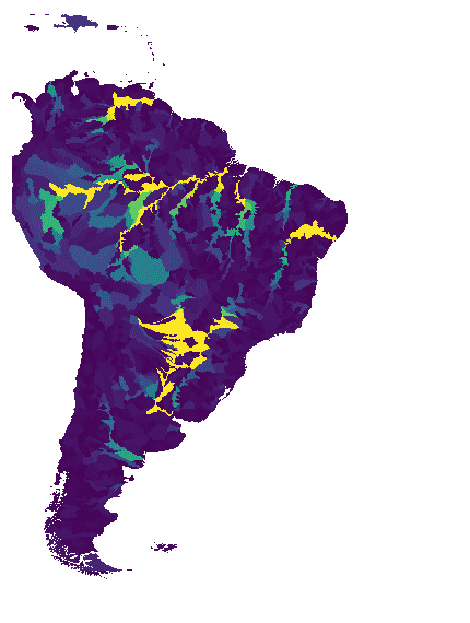
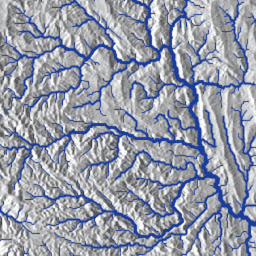
WWF HydroSHEDS 水盆级别 1

HydroSHEDS 是一种地图产品,可提供格式一致的水文地理信息,适用于区域和全球范围的应用。它提供了一套不同比例的地理参考数据集(矢量和栅格),包括河流网络、分水岭边界、排水方向和流量累积。HydroSHEDS 基于… 地球物理 水文地理 水文 HydroSHEDS SRTM 地表水-地下水 -
WWF HydroSHEDS 盆地 10 级
HydroSHEDS 是一种地图产品,可提供格式一致的水文地理信息,适用于区域和全球范围的应用。它提供了一套不同比例的地理参考数据集(矢量和栅格),包括河流网络、分水岭边界、排水方向和流量累积。HydroSHEDS 基于… 地球物理 水文地理 水文 HydroSHEDS SRTM 地表水-地下水 -
WWF HydroSHEDS 盆地级别 11

HydroSHEDS 是一种地图产品,可提供格式一致的水文地理信息,适用于区域和全球范围的应用。它提供了一套不同比例的地理参考数据集(矢量和栅格),包括河流网络、分水岭边界、排水方向和流量累积。HydroSHEDS 基于… 地球物理 水文地理 水文 HydroSHEDS SRTM 地表水-地下水 -
WWF HydroSHEDS 盆地 12 级

HydroSHEDS 是一种地图产品,可提供格式一致的水文地理信息,适用于区域和全球范围的应用。它提供了一套不同比例的地理参考数据集(矢量和栅格),包括河流网络、分水岭边界、排水方向和流量累积。HydroSHEDS 基于… 地球物理 水文地理 水文 HydroSHEDS SRTM 地表水-地下水 -
WWF HydroSHEDS 盆地级别 2

HydroSHEDS 是一种地图产品,可提供格式一致的水文地理信息,适用于区域和全球范围的应用。它提供了一套不同比例的地理参考数据集(矢量和栅格),包括河流网络、分水岭边界、排水方向和流量累积。HydroSHEDS 基于… 地球物理 水文地理 水文 HydroSHEDS SRTM 地表水-地下水 -
WWF HydroSHEDS 流域第 3 级

HydroSHEDS 是一种地图产品,可提供格式一致的水文地理信息,适用于区域和全球范围的应用。它提供了一套不同比例的地理参考数据集(矢量和栅格),包括河流网络、分水岭边界、排水方向和流量累积。HydroSHEDS 基于… 地球物理 水文地理 水文 HydroSHEDS SRTM 地表水-地下水 -
WWF HydroSHEDS 盆地级别 4

HydroSHEDS 是一种地图产品,可提供格式一致的水文地理信息,适用于区域和全球范围的应用。它提供了一套不同比例的地理参考数据集(矢量和栅格),包括河流网络、分水岭边界、排水方向和流量累积。HydroSHEDS 基于… 地球物理 水文地理 水文 HydroSHEDS SRTM 地表水-地下水 -
WWF HydroSHEDS 盆地级别 5

HydroSHEDS 是一种地图产品,可提供格式一致的水文地理信息,适用于区域和全球范围的应用。它提供了一套不同比例的地理参考数据集(矢量和栅格),包括河流网络、分水岭边界、排水方向和流量累积。HydroSHEDS 基于… 地球物理 水文地理 水文 HydroSHEDS SRTM 地表水-地下水 -
WWF HydroSHEDS 盆地级别 6

HydroSHEDS 是一种地图产品,可提供格式一致的水文地理信息,适用于区域和全球范围的应用。它提供了一套不同比例的地理参考数据集(矢量和栅格),包括河流网络、分水岭边界、排水方向和流量累积。HydroSHEDS 基于… 地球物理 水文地理 水文 HydroSHEDS SRTM 地表水-地下水 -
WWF HydroSHEDS 盆地第 7 级

HydroSHEDS 是一种地图产品,可提供格式一致的水文地理信息,适用于区域和全球范围的应用。它提供了一套不同比例的地理参考数据集(矢量和栅格),包括河流网络、分水岭边界、排水方向和流量累积。HydroSHEDS 基于… 地球物理 水文地理 水文 HydroSHEDS SRTM 地表水-地下水 -
WWF HydroSHEDS 盆地 8 级

HydroSHEDS 是一种地图产品,可提供格式一致的水文地理信息,适用于区域和全球范围的应用。它提供了一套不同比例的地理参考数据集(矢量和栅格),包括河流网络、分水岭边界、排水方向和流量累积。HydroSHEDS 基于… 地球物理 水文地理 水文 HydroSHEDS SRTM 地表水-地下水 -
WWF HydroSHEDS 盆地级别 9

HydroSHEDS 是一种地图产品,可提供格式一致的水文地理信息,适用于区域和全球范围的应用。它提供了一套不同比例的地理参考数据集(矢量和栅格),包括河流网络、分水岭边界、排水方向和流量累积。HydroSHEDS 基于… 地球物理 水文地理 水文 HydroSHEDS SRTM 地表水-地下水 -
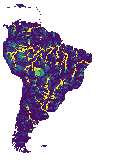
WWF HydroSHEDS 水流方向,15 角秒
HydroSHEDS 是一种地图产品,可提供格式一致的水文地理信息,适用于区域和全球范围的应用。它提供了一套不同比例的地理参考数据集(矢量和栅格),包括河流网络、分水岭边界、排水方向和流量累积。HydroSHEDS 基于… 方向 排水 流向 地球物理 水文地理 水文 -
WWF HydroSHEDS 排水方向,3 角秒

HydroSHEDS 是一种地图产品,可提供格式一致的水文地理信息,适用于区域和全球范围的应用。它提供了一套不同比例的地理参考数据集(矢量和栅格),包括河流网络、分水岭边界、排水方向和流量累积。HydroSHEDS 基于… 方向 排水 流向 地球物理 水文地理 水文 -
WWF HydroSHEDS 排水方向,30 角秒

HydroSHEDS 是一种地图产品,可提供格式一致的水文地理信息,适用于区域和全球范围的应用。它提供了一套不同比例的地理参考数据集(矢量和栅格),包括河流网络、分水岭边界、排水方向和流量累积。HydroSHEDS 基于… 方向 排水 流向 地球物理 水文地理 水文 -
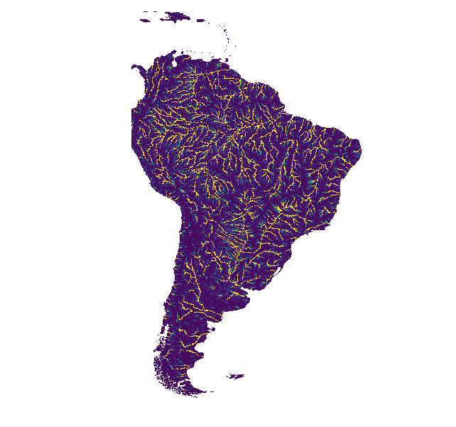
WWF HydroSHEDS 流向累积,15 角秒

HydroSHEDS 是一种地图产品,可提供格式一致的水文地理信息,适用于区域和全球范围的应用。它提供了一套不同比例的地理参考数据集(矢量和栅格),包括河流网络、分水岭边界、排水方向和流量累积。HydroSHEDS 基于… 累积 排水 流 地球物理 水文地理 水文 -
WWF HydroSHEDS 流向累积,30 角秒

HydroSHEDS 是一种地图产品,可提供格式一致的水文地理信息,适用于区域和全球范围的应用。它提供了一套不同比例的地理参考数据集(矢量和栅格),包括河流网络、分水岭边界、排水方向和流量累积。HydroSHEDS 基于… 累积 排水 流 地球物理 水文地理 水文 -
WWF HydroSHEDS Free Flowing Rivers Network v1
HydroSHEDS 是一种地图产品,可提供格式一致的水文地理信息,适用于区域和全球范围的应用。它提供了一套不同比例的地理参考数据集(矢量和栅格),包括河流网络、分水岭边界、排水方向和流量累积。HydroSHEDS 基于… 地球物理 水文地理 水文 HydroSHEDS SRTM 地表水-地下水 -
WWF HydroSHEDS 水文条件 DEM,15 角秒

HydroSHEDS 是一种地图产品,可提供格式一致的水文地理信息,适用于区域和全球范围的应用。它提供了一套不同比例的地理参考数据集(矢量和栅格),包括河流网络、分水岭边界、排水方向和流量累积。HydroSHEDS 基于… 有条件 dem 海拔 地球物理 水文 水文 -
WWF HydroSHEDS 水文条件 DEM,3 角秒
HydroSHEDS 是一种地图产品,可提供格式一致的水文地理信息,适用于区域和全球范围的应用。它提供了一套不同比例的地理参考数据集(矢量和栅格),包括河流网络、分水岭边界、排水方向和流量累积。HydroSHEDS 基于… 有条件 dem 海拔 地球物理 水文 水文 -
WWF HydroSHEDS 水文条件 DEM,30 弧秒
HydroSHEDS 是一种地图产品,可提供格式一致的水文地理信息,适用于区域和全球范围的应用。它提供了一套不同比例的地理参考数据集(矢量和栅格),包括河流网络、分水岭边界、排水方向和流量累积。HydroSHEDS 基于… 有条件 dem 海拔 地球物理 水文 水文 -
WWF HydroSHEDS 空白填充 DEM,3 角秒
HydroSHEDS 是一种地图产品,可提供格式一致的水文地理信息,适用于区域和全球范围的应用。它提供了一套不同比例的地理参考数据集(矢量和栅格),包括河流网络、分水岭边界、排水方向和流量累积。HydroSHEDS 基于… dem 海拔 地球物理 水文地理 水文 hydrosheds
Datasets tagged srtm in Earth Engine
[null,null,[],[],["The data catalogs various global elevation and hydrographic datasets. Key datasets include DEM-H and DEM-S, both Australian models derived from SRTM, offering hydrologically enforced and smoothed elevation data. SRTM data is further represented in other datasets, like the void-filled SRTM and NASADEM. Other datasets capture global building height and volume from ALOS and SRTM, and land/water masks. The HydroSHEDS and HydroATLAS datasets offer extensive hydrographic data such as drainage direction, flow accumulation, and basin boundaries.\n"]]