FAO GAUL ৫০০ মিটার সরলীকৃত: গ্লোবাল অ্যাডমিনিস্ট্রেটিভ ইউনিট লেয়ারস ২০১৫, প্রথম-স্তরের অ্যাডমিনিস্ট্রেটিভ ইউনিট 
GAUL ডেটাসেটের এই সংস্করণটি 500m-এ সরলীকৃত। গ্লোবাল অ্যাডমিনিস্ট্রেটিভ ইউনিট লেয়ারস (GAUL) বিশ্বের সকল দেশের জন্য প্রশাসনিক ইউনিট সম্পর্কে সেরা উপলব্ধ তথ্য সংকলন এবং প্রচার করে, যা প্রশাসনিক ইউনিটগুলির প্রতিনিধিত্বকারী স্থানিক ডেটাসেটের মানকীকরণে অবদান রাখে। … সীমান্ত বিভাগ ফাও গল অবকাঠামো-সীমানা প্রদেশসমূহ FAO GAUL: গ্লোবাল অ্যাডমিনিস্ট্রেটিভ ইউনিট লেয়ারস ২০১৫, প্রথম-স্তরের অ্যাডমিনিস্ট্রেটিভ ইউনিট 
গ্লোবাল অ্যাডমিনিস্ট্রেটিভ ইউনিট লেয়ারস (GAUL) বিশ্বের সকল দেশের জন্য প্রশাসনিক ইউনিট সম্পর্কে সর্বোত্তম উপলব্ধ তথ্য সংকলন এবং প্রচার করে, যা প্রশাসনিক ইউনিটগুলির প্রতিনিধিত্বকারী স্থানিক ডেটাসেটের মানকীকরণে অবদান রাখে। GAUL সর্বদা একটি ঐক্যবদ্ধ ... সহ বিশ্বব্যাপী স্তরগুলি বজায় রাখে। সীমান্ত বিভাগ ফাও গল অবকাঠামো-সীমানা প্রদেশসমূহ TIGER: মার্কিন যুক্তরাষ্ট্রের আদমশুমারি রাজ্য ২০১৬ 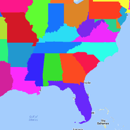
মার্কিন যুক্তরাষ্ট্রের আদমশুমারি ব্যুরো TIGER ডেটাসেটে মার্কিন যুক্তরাষ্ট্রের প্রাথমিক সরকারি বিভাগগুলির জন্য ২০১৬ সালের সীমানা রয়েছে। পঞ্চাশটি রাজ্য ছাড়াও, আদমশুমারি ব্যুরো কলম্বিয়া জেলা, পুয়ের্তো রিকো এবং প্রতিটি দ্বীপ অঞ্চল (আমেরিকান সামোয়া, ...) বিবেচনা করে। আদমশুমারি অবকাঠামো-সীমানা রাজ্য রাজ্য টেবিল টাইগার TIGER: মার্কিন যুক্তরাষ্ট্রের আদমশুমারি রাজ্য ২০১৮ 
মার্কিন যুক্তরাষ্ট্রের আদমশুমারি ব্যুরো TIGER ডেটাসেটে মার্কিন যুক্তরাষ্ট্রের প্রাথমিক সরকারি বিভাগগুলির জন্য ২০১৮ সালের সীমানা রয়েছে। পঞ্চাশটি রাজ্য ছাড়াও, আদমশুমারি ব্যুরো কলম্বিয়া জেলা, পুয়ের্তো রিকো এবং প্রতিটি দ্বীপ অঞ্চল (আমেরিকান সামোয়া, ...) বিবেচনা করে। আদমশুমারি অবকাঠামো-সীমানা রাজ্য রাজ্য টেবিল টাইগার
Datasets tagged states in Earth Engine
[null,null,[],[],["The Global Administrative Unit Layers (GAUL) datasets compile and share information on administrative units worldwide, standardizing spatial data representation. One version is simplified to 500m. The US Census Bureau TIGER datasets provide the 2016 and 2018 boundaries for primary US governmental divisions, including states, the District of Columbia, Puerto Rico, and island areas.\n"]]