Фактическое суммарное испарение для Австралии (CMRSET Landsat V2.2)
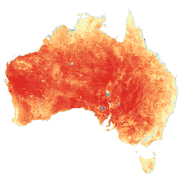
 Этот набор данных обеспечивает точную фактическую эвапотранспирацию (AET или ETa) для Австралии с использованием алгоритма CMRSET. Полоса AET (названная «ETa») содержит среднее дневное значение модели CMRSET для всех безоблачных наблюдений Landsat в этом месяце (обозначено значением 3 в данных AET… сельское хозяйство, Австралия, csiro , испарение , эвапотранспирация, полученные со спутника SLGA: Сетка почв и ландшафтов Австралии (атрибуты почвы) 
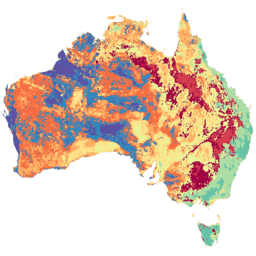
Сетка почв и ландшафтов Австралии (SLGA) представляет собой комплексный набор данных об атрибутах почвы по всей Австралии с разрешением 3 угловых секунды (~ 90 м пикселей). Поверхности являются результатом моделирования, которое описывает пространственное распределение свойств почвы с использованием существующих данных о почве и экологических данных. Австралийская почвенная крачка Чиро
Datasets tagged tern in Earth Engine
[null,null,[],[[["\u003cp\u003eThe Soil and Landscape Grid of Australia (SLGA) dataset provides comprehensive soil attribute information for Australia at ~90m resolution.\u003c/p\u003e\n"],["\u003cp\u003eThe Actual Evapotranspiration for Australia dataset offers daily evapotranspiration estimates derived from cloud-free Landsat observations using the CMRSET algorithm.\u003c/p\u003e\n"]]],[],null,["# Datasets tagged tern in Earth Engine\n\n-\n\n |-------------------------------------------------------------------------------------------------------------------------------------------------------------------------------------------------------------------------------------------------------------------------------------------------------------------------------------------------|\n | [### Actual Evapotranspiration for Australia (CMRSET Landsat V2.2)](/earth-engine/datasets/catalog/TERN_AET_CMRSET_LANDSAT_V2_2) |\n | This dataset provides accurate actual evapotranspiration (AET or ETa) for Australia using the CMRSET algorithm. The AET band (named 'ETa') contains the average daily value from the CMRSET model for all cloud-free Landsat observations in that month (indicated with value 3 in the AET Data ... |\n | [agriculture](/earth-engine/datasets/tags/agriculture) [australia](/earth-engine/datasets/tags/australia) [csiro](/earth-engine/datasets/tags/csiro) [evaporation](/earth-engine/datasets/tags/evaporation) [evapotranspiration](/earth-engine/datasets/tags/evapotranspiration) [landsat-derived](/earth-engine/datasets/tags/landsat-derived) |\n\n-\n\n |---------------------------------------------------------------------------------------------------------------------------------------------------------------------------------------------------------------------------------------------------------------------------------------------------------------------|\n | [### SLGA: Soil and Landscape Grid of Australia (Soil Attributes)](/earth-engine/datasets/catalog/CSIRO_SLGA) |\n | The Soil and Landscape Grid of Australia (SLGA) is a comprehensive dataset of soil attributes across Australia at 3 arc-second resolution (\\~90m pixels). The surfaces are the outcomes from modelling that describe the spatial distribution of the soil attributes using existing soil data and environmental ... |\n | [australia](/earth-engine/datasets/tags/australia) [csiro](/earth-engine/datasets/tags/csiro) [soil](/earth-engine/datasets/tags/soil) [tern](/earth-engine/datasets/tags/tern) |"]]