AG100: مجموعه دادههای گسیلندگی جهانی ASTER با طول موج ۱۰۰ متر V003 
پایگاه دادهی گسیلندگی جهانی رادیومترهای پیشرفتهی فضابرد گسیل و بازتاب حرارتی (ASTER-GED) توسط آزمایشگاه پیشرانش جت (JPL) سازمان ملی هوانوردی و فضایی (ناسا) در موسسهی فناوری کالیفرنیا توسعه داده شده است. این محصول شامل میانگین گسیلندگی و انحراف معیار برای هر 5 سنجندهی حرارتی فروسرخ ASTER ... ارتفاع آستر، گسیلندگی، ژئوفیزیک، مادون قرمز، jpl رادیانس ASTER L1T 
توجه: به دلیل مشکلات فنی دستگاه ASTER، بین ۲۸ نوامبر ۲۰۲۴ و ۱۶ ژانویه ۲۰۲۵، فاصلهای در جمعآوری دادهها وجود دارد. برای اطلاعات بیشتر به اطلاعیه USGS مراجعه کنید. رادیومتر پیشرفته فضابرد انتشار و بازتاب حرارتی (ASTER) یک تصویرگر چندطیفی است که... تصاویر آستر، تصاویر ماهوارهای ناسا نیر رادیانس شرکتها: اطلاعات آتشسوزی برای سیستم مدیریت منابع 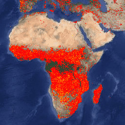
نسخه Earth Engine از مجموعه دادههای سیستم مدیریت منابع اطلاعات آتشسوزی (FIRMS) شامل محصول تشخیص آتشسوزی LANCE به صورت رستری است. مکانهای آتشسوزی فعال تقریباً بلادرنگ (NRT) توسط LANCE با استفاده از محصول استاندارد ناهنجاریهای آتشسوزی و حرارتی MODIS MOD14/MYD14 پردازش میشوند. هر ... شرکتهای آتشنشانی eosdis، نقاط داغ ژئوفیزیکی، لنس VJ114IMGTDL_NRT رستر روزانه: VIIRS (NOAA-20) باند 375 متری آتش فعال 
محصول تشخیص آتش فعال NOAA-20 (JPSS-1) مجموعه رادیومتر تصویربرداری مادون قرمز مرئی (VIIRS) بر اساس دادههای با وضوح اسمی ۳۷۵ متر این دستگاه است. در مقایسه با سایر محصولات تشخیص آتش ماهوارهای با وضوح کمتر (≥ ۱ کیلومتر)، دادههای بهبود یافته ۳۷۵ متر، پاسخ بهتری نسبت به آتشسوزیهای نسبتاً کوچک ارائه میدهند... شرکتهای آتشنشانی eosdis، نقاط داغ ژئوفیزیکی، لنس VNP14IMGTDL_NRT رستر روزانه: VIIRS (S-NPP) باند ۳۷۵ متری آتش فعال 
محصول تشخیص آتش فعال Suomi NPP با تصویربرداری مادون قرمز مرئی (VIIRS) بر اساس دادههای با وضوح اسمی ۳۷۵ متر این دستگاه است. در مقایسه با سایر محصولات تشخیص آتش ماهوارهای با وضوح کمتر (≥ ۱ کیلومتر)، دادههای بهبود یافته ۳۷۵ متر، پاسخ بهتری نسبت به آتشسوزیهای نسبتاً کوچک ارائه میدهند... شرکتهای آتشنشانی eosdis، نقاط داغ ژئوفیزیکی، لنس
Datasets tagged thermal in Earth Engine
[null,null,[],[],[]]