-
RCMAP Rangeland Component Timeseries (1985-2023), v06
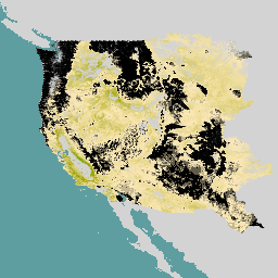
„Zbiór danych RCMAP (Rangeland Condition Monitoring Assessment and Projection) określa procent pokrycia komponentów pastwisk w zachodniej części Ameryki Północnej na podstawie zdjęć Landsat z lat 1985–2023. Pakiet produktów RCMAP składa się z 10 komponentów ułamkowych: roczne rośliny zielne, nieporośnięty teren, rośliny zielne, ściółka, krzewy inne niż bylica, wieloletnie rośliny zielne, bylica … climate-change disturbance landsat-derived landuse-landcover nlcd rangeland -
RCMAP Rangeland Trends Year for Component Timeseries (1985-2023), v06
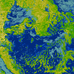
Kolekcja obejmuje roczne produkty RCMAP z lat 1985–2023. Zbiór danych RCMAP (Rangeland Condition Monitoring Assessment and Projection) określa procent pokrycia komponentów pastwisk w zachodniej części Ameryki Północnej na podstawie zdjęć Landsat z lat 1985–2023. Pakiet produktów RCMAP składa się z 10 komponentów ułamkowych: roczny… climate-change disturbance landsat-derived landuse-landcover nlcd rangeland -
RCMAP Rangeland Trends for Component Timeseries (1985-2023), v06
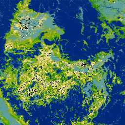
Zbiór danych RCMAP (Rangeland Condition Monitoring Assessment and Projection) określa procent pokrycia komponentów pastwisk w zachodniej części Ameryki Północnej na podstawie zdjęć Landsat z lat 1985–2023. Pakiet produktów RCMAP składa się z 10 komponentów ułamkowych: roczne rośliny zielne, nieporośnięty teren, rośliny zielne, ściółka, krzewy inne niż bylica, wieloletnie rośliny zielne, bylica … climate-change disturbance landsat-derived landuse-landcover nlcd rangeland
Datasets tagged trends in Earth Engine
[null,null,[],[],["The RCMAP dataset, spanning 1985-2023, uses Landsat imagery to measure the percent cover of ten rangeland components in western North America. These components include annual herbaceous, bare ground, litter, sagebrush, and others. The dataset includes timeseries data, trends, and yearly products, enabling analysis of rangeland changes. This data helps assess climate change, disturbances, and rangeland trends.\n"]]