-
GLCF: Landsat Global Inland Water
Set data Global Inland Water menunjukkan badan air permukaan di pedalaman, termasuk danau, sungai, dan waduk air tawar dan asin. Dari epoch GLS 2000, 3.650.723 km2 perairan pedalaman diidentifikasi, sekitar tiga perempatnya berada di Amerika Utara dan Asia. Hutan boreal dan tundra … glcf landsat-derived nasa surface-ground-water umd water -
Perubahan Tutupan Hutan Global (GFCC) Tutupan Pohon Multi-Tahun Global 30 m
Lapisan tutupan pohon Landsat Vegetation Continuous Fields (VCF) berisi estimasi persentase tanah horizontal di setiap piksel 30 m yang tertutup oleh vegetasi berkayu dengan tinggi lebih dari 5 meter. Set data tersedia untuk empat epoch yang berpusat pada tahun 2000, 2005, 2010 … forest forest-biomass glcf landsat-derived nasa umd -
Hansen Global Forest Change v1.12 (2000-2024)
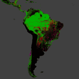
Hasil dari analisis deret waktu gambar Landsat dalam mendeskripsikan perubahan dan luas hutan global. Band 'pertama' dan 'terakhir' adalah citra multispektral referensi dari tahun pertama dan terakhir yang tersedia untuk band spektral Landsat yang sesuai dengan merah, NIR, SWIR1, dan SWIR2. Gambar komposit referensi mewakili … forest forest-biomass geophysical landsat-derived umd -
Hutan Tropis Basah Primer
Hutan tropis lembab primer menyediakan banyak jasa ekosistem global, tetapi terus terancam penggundulan karena faktor pendorong ekonomi. Untuk memfasilitasi perencanaan penggunaan lahan nasional dan menyeimbangkan sasaran pembangunan ekonomi dan pemeliharaan jasa ekosistem, peta hutan tropis lembab primer telah dibuat … forest forest-biomass global landsat-derived umd -
Set Data Stok Karbon Tingkat Nasional Pantropis WHRC
Peta tingkat nasional tentang kepadatan biomassa berkayu hidup di atas tanah untuk negara tropis pada ketinggian 500 m. Set data ini disusun dari kombinasi pengukuran lapangan yang berlokasi sama, pengamatan LiDAR, dan gambar yang direkam dari Moderate Resolution Imaging Spectroradiometer (MODIS). biomassa di atas tanah karbon biomassa hutan geofisik umd
Datasets tagged umd in Earth Engine
[null,null,[],[[["\u003cp\u003eThis webpage provides access to various datasets related to global forest cover, tree cover, and biomass.\u003c/p\u003e\n"],["\u003cp\u003eDatasets offer insights into forest change, including deforestation and primary forest identification.\u003c/p\u003e\n"],["\u003cp\u003eInformation on global inland water bodies, such as lakes and rivers, is also available.\u003c/p\u003e\n"],["\u003cp\u003eData is derived from sources like Landsat and MODIS imagery, offering high-resolution observations.\u003c/p\u003e\n"],["\u003cp\u003eThese datasets support research on carbon stock, land use planning, and ecosystem services.\u003c/p\u003e\n"]]],[],null,["# Datasets tagged umd in Earth Engine\n\n-\n\n |-------------------------------------------------------------------------------------------------------------------------------------------------------------------------------------------------------------------------------------------------------------------------------------------------------------|\n | [### GLCF: Landsat Global Inland Water](/earth-engine/datasets/catalog/GLCF_GLS_WATER) |\n | The Global Inland Water dataset shows inland surface water bodies, including fresh and saline lakes, rivers, and reservoirs. From the GLS 2000 epoch, 3,650,723 km2 of inland water were identified, around three quarters of which were in North America and Asia. Boreal forests and tundra ... |\n | [glcf](/earth-engine/datasets/tags/glcf) [landsat-derived](/earth-engine/datasets/tags/landsat-derived) [nasa](/earth-engine/datasets/tags/nasa) [surface-ground-water](/earth-engine/datasets/tags/surface-ground-water) [umd](/earth-engine/datasets/tags/umd) [water](/earth-engine/datasets/tags/water) |\n\n-\n\n |---------------------------------------------------------------------------------------------------------------------------------------------------------------------------------------------------------------------------------------------------------------------------------------------------|\n | [### Global Forest Cover Change (GFCC) Tree Cover Multi-Year Global 30m](/earth-engine/datasets/catalog/NASA_MEASURES_GFCC_TC_v3) |\n | The Landsat Vegetation Continuous Fields (VCF) tree cover layers contain estimates of the percentage of horizontal ground in each 30-m pixel covered by woody vegetation greater than 5 meters in height. The dataset is available for four epochs centered on the years 2000, 2005, 2010 ... |\n | [forest](/earth-engine/datasets/tags/forest) [forest-biomass](/earth-engine/datasets/tags/forest-biomass) [glcf](/earth-engine/datasets/tags/glcf) [landsat-derived](/earth-engine/datasets/tags/landsat-derived) [nasa](/earth-engine/datasets/tags/nasa) [umd](/earth-engine/datasets/tags/umd) |\n\n-\n\n |------------------------------------------------------------------------------------------------------------------------------------------------------------------------------------------------------------------------------------------------------------------------------------------------------------------------------------|\n | [### Hansen Global Forest Change v1.12 (2000-2024)](/earth-engine/datasets/catalog/UMD_hansen_global_forest_change_2024_v1_12) |\n | Results from time-series analysis of Landsat images in characterizing global forest extent and change. The 'first' and 'last' bands are reference multispectral imagery from the first and last available years for Landsat spectral bands corresponding to red, NIR, SWIR1, and SWIR2. Reference composite imagery represents ... |\n | [forest](/earth-engine/datasets/tags/forest) [forest-biomass](/earth-engine/datasets/tags/forest-biomass) [geophysical](/earth-engine/datasets/tags/geophysical) [landsat-derived](/earth-engine/datasets/tags/landsat-derived) [umd](/earth-engine/datasets/tags/umd) |\n\n-\n\n |-----------------------------------------------------------------------------------------------------------------------------------------------------------------------------------------------------------------------------------------------------------------------------------------------------------------------------------|\n | [### Primary Humid Tropical Forests](/earth-engine/datasets/catalog/UMD_GLAD_PRIMARY_HUMID_TROPICAL_FORESTS_v1) |\n | Primary humid tropical forests provide numerous global ecosystem services, but are under continuing threat of clearing from economic drivers. To facilitate national land use planning and balancing the goals of economic development and maintenance of ecosystem services, a primary humid tropical forest map was created ... |\n | [forest](/earth-engine/datasets/tags/forest) [forest-biomass](/earth-engine/datasets/tags/forest-biomass) [global](/earth-engine/datasets/tags/global) [landsat-derived](/earth-engine/datasets/tags/landsat-derived) [umd](/earth-engine/datasets/tags/umd) |\n\n-\n\n |---------------------------------------------------------------------------------------------------------------------------------------------------------------------------------------------------------------------------------------------------------------------------------------------------------------|\n | [### WHRC Pantropical National Level Carbon Stock Dataset](/earth-engine/datasets/catalog/WHRC_biomass_tropical) |\n | A national-level map of above-ground live woody biomass density for tropical countries at 500m. This dataset was assembled from a combination of co-located field measurements, LiDAR observations, and imagery recorded from the Moderate Resolution Imaging Spectroradiometer (MODIS). |\n | [aboveground](/earth-engine/datasets/tags/aboveground) [biomass](/earth-engine/datasets/tags/biomass) [carbon](/earth-engine/datasets/tags/carbon) [forest-biomass](/earth-engine/datasets/tags/forest-biomass) [geophysical](/earth-engine/datasets/tags/geophysical) [umd](/earth-engine/datasets/tags/umd) |"]]