আর্কটিকডেম মোজাইক V4.1 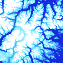
আর্কটিকডেম হল ন্যাশনাল জিওস্পেশিয়াল-ইন্টেলিজেন্স এজেন্সি (এনজিএ) এবং ন্যাশনাল সায়েন্স ফাউন্ডেশন (এনএসএফ) এর একটি পাবলিক-প্রাইভেট উদ্যোগ যা অপটিক্যাল স্টেরিও ইমেজরি, হাই-পারফরম্যান্স কম্পিউটিং এবং ওপেন সোর্স ফটোগ্রামেট্রি সফ্টওয়্যার ব্যবহার করে স্বয়ংক্রিয়ভাবে আর্কটিকের একটি উচ্চ-রেজোলিউশন, উচ্চ-মানের ডিজিটাল সারফেস মডেল (ডিএসএম) তৈরি করে। এর মধ্যে রয়েছে গাছপালা, গাছের ছাউনি, ভবন এবং … আর্কটিক ডেম এলিভেশন-ভূগোল ভূ-ভৌতিক পিজিসি ইউএমএন আর্কটিকডেম স্ট্রিপস 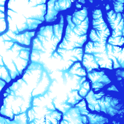
আর্কটিকডেম হল ন্যাশনাল জিওস্পেশিয়াল-ইন্টেলিজেন্স এজেন্সি (এনজিএ) এবং ন্যাশনাল সায়েন্স ফাউন্ডেশন (এনএসএফ) এর একটি পাবলিক-প্রাইভেট উদ্যোগ যা অপটিক্যাল স্টেরিও ইমেজরি, হাই-পারফরম্যান্স কম্পিউটিং এবং ওপেন সোর্স ফটোগ্রামেট্রি সফ্টওয়্যার ব্যবহার করে স্বয়ংক্রিয়ভাবে আর্কটিকের একটি উচ্চ-রেজোলিউশন, উচ্চ-মানের ডিজিটাল সারফেস মডেল (ডিএসএম) তৈরি করে। এর মধ্যে রয়েছে গাছপালা, গাছের ছাউনি, ভবন এবং … আর্কটিক ডেম এলিভেশন-ভূগোল ভূ-ভৌতিক পিজিসি ইউএমএন রেমা মোজাইক 
রেফারেন্স এলিভেশন মডেল অফ অ্যান্টার্কটিকা (REMA) হল অ্যান্টার্কটিকার একটি উচ্চ রেজোলিউশন, টাইম-স্ট্যাম্পড ডিজিটাল সারফেস মডেল (DSM) যা 2-মিটার এবং 8-মিটার স্থানিক রেজোলিউশনে তৈরি। মোজাইক করা DEM ফাইলগুলি একাধিক স্ট্রিপ থেকে সংকলিত হয় যা সহ-নিবন্ধিত, মিশ্রিত এবং পালকযুক্ত করা হয়েছে যাতে প্রান্ত-ম্যাচিং শিল্পকর্মগুলি হ্রাস করা যায়। ডেম এলিভেশন-ভূগোল ভূ- পদার্থবিদ্যা পিজিসি রেমা উমন REMA স্ট্রিপস ২ মি 
রেফারেন্স এলিভেশন মডেল অফ অ্যান্টার্কটিকা (REMA) হল অ্যান্টার্কটিকার একটি উচ্চ রেজোলিউশন, টাইম-স্ট্যাম্পড ডিজিটাল সারফেস মডেল (DSM) যা 2-মিটার এবং 8-মিটার স্থানিক রেজোলিউশনে তৈরি। স্ট্রিপ DEM ফাইলগুলি ইনপুট স্টেরিওস্কোপিক ইমেজরি পেয়ার স্ট্রিপগুলির ওভারল্যাপিং এলাকার সাথে মিলে যায় কারণ সেগুলি ডিজিটালগ্লোবের … ডেম এলিভেশন-ভূগোল ভূ- পদার্থবিদ্যা পিজিসি রেমা উমন REMA স্ট্রিপস ৮ মি 
রেফারেন্স এলিভেশন মডেল অফ অ্যান্টার্কটিকা (REMA) হল অ্যান্টার্কটিকার একটি উচ্চ রেজোলিউশন, টাইম-স্ট্যাম্পড ডিজিটাল সারফেস মডেল (DSM) যা 2-মিটার এবং 8-মিটার স্থানিক রেজোলিউশনে তৈরি। স্ট্রিপ DEM ফাইলগুলি ইনপুট স্টেরিওস্কোপিক ইমেজরি পেয়ার স্ট্রিপগুলির ওভারল্যাপিং এলাকার সাথে মিলে যায় কারণ সেগুলি ডিজিটালগ্লোবের … ডেম এলিভেশন-ভূগোল ভূ- পদার্থবিদ্যা পিজিসি রেমা উমন
Datasets tagged umn in Earth Engine
[null,null,[],[],[]]