اختيار المكان الحالي وعرض التفاصيل على خريطة
يوضح هذا البرنامج التعليمي إنشاء تطبيق iOS يمكنه استرداد الموقع الحالي للجهاز، ويحدد المواقع المحتملة، ويطلب من المستخدم اختيار أفضل نتيجة مطابِقة، ويعرض محدِّد خريطة للموقع الذي تم اختياره.
ويناسب هذا البرنامج الأشخاص الذين لديهم معرفة مسبقة أو متوسطة بأداة Swift أو Objective-C ويتمتعون بمعرفة عامة عن Xcode. للحصول على دليل متقدم حول إنشاء الخرائط، يمكنك قراءة دليل مطوّري البرامج.
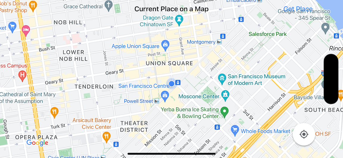
ستنشئ الخريطة التالية باستخدام هذا البرنامج التعليمي. يتم وضع محدّد الخريطة في سان فرانسيسكو، كاليفورنيا، ولكنها ستنتقل إلى المكان الذي يوجد فيه الجهاز أو المحاكي.
يستخدم هذا الدليل التوجيهي حزمة تطوير البرامج (SDK) لميزة "الأماكن" في نظام التشغيل iOS وحزمة تطوير البرامج بالاستناد إلى بيانات "خرائط Google" لنظام التشغيل iOS، وإطار عمل الموقع الجغرافي الأساسي في Apple.
الحصول على الرمز
استنسِخ أو نزِّل مستودع نماذج "خرائط Google" على أجهزة iOS من GitHub.يمكنك بدلاً من ذلك النقر على الزر التالي لتنزيل رمز المصدر:
وحدة تحكُّم الخريطة في Swift
/*
 * Copyright 2016 Google Inc. All rights reserved.
 *
 *
 * Licensed under the Apache License, Version 2.0 (the "License"); you may not use this
 * file except in compliance with the License. You may obtain a copy of the License at
 *
 *     http://www.apache.org/licenses/LICENSE-2.0
 *
 * Unless required by applicable law or agreed to in writing, software distributed under
 * the License is distributed on an "AS IS" BASIS, WITHOUT WARRANTIES OR CONDITIONS OF
 * ANY KIND, either express or implied. See the License for the specific language governing
 * permissions and limitations under the License.
 */

import UIKit
import GoogleMaps
import GooglePlaces

class MapViewController: UIViewController {

  var locationManager: CLLocationManager!
  var currentLocation: CLLocation?
  var mapView: GMSMapView!
  var placesClient: GMSPlacesClient!
  var preciseLocationZoomLevel: Float = 15.0
  var approximateLocationZoomLevel: Float = 10.0

  // An array to hold the list of likely places.
  var likelyPlaces: [GMSPlace] = []

  // The currently selected place.
  var selectedPlace: GMSPlace?

  // Update the map once the user has made their selection.
  @IBAction func unwindToMain(segue: UIStoryboardSegue) {
    // Clear the map.
    mapView.clear()

    // Add a marker to the map.
    if let place = selectedPlace {
      let marker = GMSMarker(position: place.coordinate)
      marker.title = selectedPlace?.name
      marker.snippet = selectedPlace?.formattedAddress
      marker.map = mapView
    }

    listLikelyPlaces()
  }

  override func viewDidLoad() {
    super.viewDidLoad()

    // Initialize the location manager.
    locationManager = CLLocationManager()
    locationManager.desiredAccuracy = kCLLocationAccuracyBest
    locationManager.requestWhenInUseAuthorization()
    locationManager.distanceFilter = 50
    locationManager.startUpdatingLocation()
    locationManager.delegate = self

    placesClient = GMSPlacesClient.shared()

    // A default location to use when location permission is not granted.
    let defaultLocation = CLLocation(latitude: -33.869405, longitude: 151.199)

    // Create a map.
    let zoomLevel = locationManager.accuracyAuthorization == .fullAccuracy ? preciseLocationZoomLevel : approximateLocationZoomLevel
    let camera = GMSCameraPosition.camera(withLatitude: defaultLocation.coordinate.latitude,
                                          longitude: defaultLocation.coordinate.longitude,
                                          zoom: zoomLevel)
    mapView = GMSMapView.map(withFrame: view.bounds, camera: camera)
    mapView.settings.myLocationButton = true
    mapView.autoresizingMask = [.flexibleWidth, .flexibleHeight]
    mapView.isMyLocationEnabled = true

    // Add the map to the view, hide it until we've got a location update.
    view.addSubview(mapView)
    mapView.isHidden = true

    listLikelyPlaces()
  }

  // Populate the array with the list of likely places.
  func listLikelyPlaces() {
    // Clean up from previous sessions.
    likelyPlaces.removeAll()

    let placeFields: GMSPlaceField = [.name, .coordinate]
    placesClient.findPlaceLikelihoodsFromCurrentLocation(withPlaceFields: placeFields) { (placeLikelihoods, error) in
      guard error == nil else {
        // TODO: Handle the error.
        print("Current Place error: \(error!.localizedDescription)")
        return
      }

      guard let placeLikelihoods = placeLikelihoods else {
        print("No places found.")
        return
      }

      // Get likely places and add to the list.
      for likelihood in placeLikelihoods {
        let place = likelihood.place
        self.likelyPlaces.append(place)
      }
    }
  }

  // Prepare the segue.
  override func prepare(for segue: UIStoryboardSegue, sender: Any?) {
    if segue.identifier == "segueToSelect" {
      if let nextViewController = segue.destination as? PlacesViewController {
        nextViewController.likelyPlaces = likelyPlaces
      }
    }
  }
}

// Delegates to handle events for the location manager.
extension MapViewController: CLLocationManagerDelegate {

  // Handle incoming location events.
  func locationManager(_ manager: CLLocationManager, didUpdateLocations locations: [CLLocation]) {
    let location: CLLocation = locations.last!
    print("Location: \(location)")

    let zoomLevel = locationManager.accuracyAuthorization == .fullAccuracy ? preciseLocationZoomLevel : approximateLocationZoomLevel
    let camera = GMSCameraPosition.camera(withLatitude: location.coordinate.latitude,
                                          longitude: location.coordinate.longitude,
                                          zoom: zoomLevel)

    if mapView.isHidden {
      mapView.isHidden = false
      mapView.camera = camera
    } else {
      mapView.animate(to: camera)
    }

    listLikelyPlaces()
  }

  // Handle authorization for the location manager.
  func locationManager(_ manager: CLLocationManager, didChangeAuthorization status: CLAuthorizationStatus) {
    // Check accuracy authorization
    let accuracy = manager.accuracyAuthorization
    switch accuracy {
    case .fullAccuracy:
        print("Location accuracy is precise.")
    case .reducedAccuracy:
        print("Location accuracy is not precise.")
    @unknown default:
      fatalError()
    }

    // Handle authorization status
    switch status {
    case .restricted:
      print("Location access was restricted.")
    case .denied:
      print("User denied access to location.")
      // Display the map using the default location.
      mapView.isHidden = false
    case .notDetermined:
      print("Location status not determined.")
    case .authorizedAlways: fallthrough
    case .authorizedWhenInUse:
      print("Location status is OK.")
    @unknown default:
      fatalError()
    }
  }

  // Handle location manager errors.
  func locationManager(_ manager: CLLocationManager, didFailWithError error: Error) {
    locationManager.stopUpdatingLocation()
    print("Error: \(error)")
  }
}
وحدة تحكم Swift PlacesView
/*
 * Copyright 2017 Google Inc. All rights reserved.
 *
 *
 * Licensed under the Apache License, Version 2.0 (the "License"); you may not use this
 * file except in compliance with the License. You may obtain a copy of the License at
 *
 *     http://www.apache.org/licenses/LICENSE-2.0
 *
 * Unless required by applicable law or agreed to in writing, software distributed under
 * the License is distributed on an "AS IS" BASIS, WITHOUT WARRANTIES OR CONDITIONS OF
 * ANY KIND, either express or implied. See the License for the specific language governing
 * permissions and limitations under the License.
 */

import UIKit
import GooglePlaces

class PlacesViewController: UIViewController {

  @IBOutlet weak var tableView: UITableView!

  // An array to hold the list of possible locations.
  var likelyPlaces: [GMSPlace] = []
  var selectedPlace: GMSPlace?

  // Cell reuse id (cells that scroll out of view can be reused).
  let cellReuseIdentifier = "cell"

  override func viewDidLoad() {
    super.viewDidLoad()

    // Register the table view cell class and its reuse id.
    tableView.register(UITableViewCell.self, forCellReuseIdentifier: cellReuseIdentifier)

    // This view controller provides delegate methods and row data for the table view.
    tableView.delegate = self
    tableView.dataSource = self

    tableView.reloadData()
  }

  // Pass the selected place to the new view controller.
  override func prepare(for segue: UIStoryboardSegue, sender: Any?) {
    if segue.identifier == "unwindToMain" {
      if let nextViewController = segue.destination as? MapViewController {
        nextViewController.selectedPlace = selectedPlace
      }
    }
  }
}

// Respond when a user selects a place.
extension PlacesViewController: UITableViewDelegate {
  func tableView(_ tableView: UITableView, didSelectRowAt indexPath: IndexPath) {
    selectedPlace = likelyPlaces[indexPath.row]
    performSegue(withIdentifier: "unwindToMain", sender: self)
  }

  // Adjust cell height to only show the first five items in the table
  // (scrolling is disabled in IB).
  func tableView(_ tableView: UITableView, heightForRowAt indexPath: IndexPath) -> CGFloat {
    return self.tableView.frame.size.height/5
  }

  // Make table rows display at proper height if there are less than 5 items.
  func tableView(_ tableView: UITableView, heightForFooterInSection section: Int) -> CGFloat {
    if (section == tableView.numberOfSections - 1) {
      return 1
    }
    return 0
  }
}

// Populate the table with the list of most likely places.
extension PlacesViewController: UITableViewDataSource {
  func tableView(_ tableView: UITableView, numberOfRowsInSection section: Int) -> Int {
    return likelyPlaces.count
  }

  func tableView(_ tableView: UITableView, cellForRowAt indexPath: IndexPath) -> UITableViewCell {
    let cell = tableView.dequeueReusableCell(withIdentifier: cellReuseIdentifier, for: indexPath)
    let collectionItem = likelyPlaces[indexPath.row]

    cell.textLabel?.text = collectionItem.name

    return cell
  }
}
وحدة تحكُّم Obj-C في MapView
//
//  MapsViewController.m
//  current-place-on-map
//
//  Created by Chris Arriola on 9/18/20.
//  Copyright © 2020 William French. All rights reserved.
//

#import "MapViewController.h"
#import "PlacesViewController.h"
@import CoreLocation;
@import GooglePlaces;
@import GoogleMaps;

@interface MapViewController () <CLLocationManagerDelegate>

@end

@implementation MapViewController {
  CLLocationManager *locationManager;
  CLLocation * _Nullable currentLocation;
  GMSMapView *mapView;
  GMSPlacesClient *placesClient;
  float preciseLocationZoomLevel;
  float approximateLocationZoomLevel;

  // An array to hold the list of likely places.
  NSMutableArray<GMSPlace *> *likelyPlaces;

  // The currently selected place.
  GMSPlace * _Nullable selectedPlace;
}

- (void)viewDidLoad {
  [super viewDidLoad];
  preciseLocationZoomLevel = 15.0;
  approximateLocationZoomLevel = 15.0;

  // Initialize the location manager.
  locationManager = [[CLLocationManager alloc] init];
  locationManager.desiredAccuracy = kCLLocationAccuracyBest;
  [locationManager requestWhenInUseAuthorization];
  locationManager.distanceFilter = 50;
  [locationManager startUpdatingLocation];
  locationManager.delegate = self;

  placesClient = [GMSPlacesClient sharedClient];

  // A default location to use when location permission is not granted.
  CLLocationCoordinate2D defaultLocation = CLLocationCoordinate2DMake(-33.869405, 151.199);

  // Create a map.
  float zoomLevel = locationManager.accuracyAuthorization == CLAccuracyAuthorizationFullAccuracy ? preciseLocationZoomLevel : approximateLocationZoomLevel;
  GMSCameraPosition *camera = [GMSCameraPosition cameraWithLatitude:defaultLocation.latitude
                                                          longitude:defaultLocation.longitude
                                                               zoom:zoomLevel];
  mapView = [GMSMapView mapWithFrame:self.view.bounds camera:camera];
  mapView.settings.myLocationButton = YES;
  mapView.autoresizingMask = UIViewAutoresizingFlexibleWidth | UIViewAutoresizingFlexibleHeight;
  mapView.myLocationEnabled = YES;

  // Add the map to the view, hide it until we've got a location update.
  [self.view addSubview:mapView];
  mapView.hidden = YES;

  [self listLikelyPlaces];
}

// Populate the array with the list of likely places.
- (void) listLikelyPlaces
{
  // Clean up from previous sessions.
  likelyPlaces = [NSMutableArray array];

  GMSPlaceField placeFields = GMSPlaceFieldName | GMSPlaceFieldCoordinate;
  [placesClient findPlaceLikelihoodsFromCurrentLocationWithPlaceFields:placeFields callback:^(NSArray<GMSPlaceLikelihood *> * _Nullable likelihoods, NSError * _Nullable error) {
    if (error != nil) {
      // TODO: Handle the error.
      NSLog(@"Current Place error: %@", error.localizedDescription);
      return;
    }

    if (likelihoods == nil) {
      NSLog(@"No places found.");
      return;
    }

    for (GMSPlaceLikelihood *likelihood in likelihoods) {
      GMSPlace *place = likelihood.place;
      [likelyPlaces addObject:place];
    }
  }];
}

// Update the map once the user has made their selection.
- (void) unwindToMain:(UIStoryboardSegue *)segue
{
  // Clear the map.
  [mapView clear];

  // Add a marker to the map.
  if (selectedPlace != nil) {
    GMSMarker *marker = [GMSMarker markerWithPosition:selectedPlace.coordinate];
    marker.title = selectedPlace.name;
    marker.snippet = selectedPlace.formattedAddress;
    marker.map = mapView;
  }

  [self listLikelyPlaces];
}

// Prepare the segue.
- (void)prepareForSegue:(UIStoryboardSegue *)segue sender:(id)sender
{
  if ([segue.identifier isEqualToString:@"segueToSelect"]) {
    if ([segue.destinationViewController isKindOfClass:[PlacesViewController class]]) {
      PlacesViewController *placesViewController = (PlacesViewController *)segue.destinationViewController;
      placesViewController.likelyPlaces = likelyPlaces;
    }
  }
}

// Delegates to handle events for the location manager.
#pragma mark - CLLocationManagerDelegate

// Handle incoming location events.
- (void)locationManager:(CLLocationManager *)manager didUpdateLocations:(NSArray<CLLocation *> *)locations
{
  CLLocation *location = locations.lastObject;
  NSLog(@"Location: %@", location);

  float zoomLevel = locationManager.accuracyAuthorization == CLAccuracyAuthorizationFullAccuracy ? preciseLocationZoomLevel : approximateLocationZoomLevel;
  GMSCameraPosition * camera = [GMSCameraPosition cameraWithLatitude:location.coordinate.latitude
                                                           longitude:location.coordinate.longitude
                                                                zoom:zoomLevel];

  if (mapView.isHidden) {
    mapView.hidden = NO;
    mapView.camera = camera;
  } else {
    [mapView animateToCameraPosition:camera];
  }

  [self listLikelyPlaces];
}

// Handle authorization for the location manager.
- (void)locationManager:(CLLocationManager *)manager didChangeAuthorizationStatus:(CLAuthorizationStatus)status
{
  // Check accuracy authorization
  CLAccuracyAuthorization accuracy = manager.accuracyAuthorization;
  switch (accuracy) {
    case CLAccuracyAuthorizationFullAccuracy:
      NSLog(@"Location accuracy is precise.");
      break;
    case CLAccuracyAuthorizationReducedAccuracy:
      NSLog(@"Location accuracy is not precise.");
      break;
  }

  // Handle authorization status
  switch (status) {
    case kCLAuthorizationStatusRestricted:
      NSLog(@"Location access was restricted.");
      break;
    case kCLAuthorizationStatusDenied:
      NSLog(@"User denied access to location.");
      // Display the map using the default location.
      mapView.hidden = NO;
    case kCLAuthorizationStatusNotDetermined:
      NSLog(@"Location status not determined.");
    case kCLAuthorizationStatusAuthorizedAlways:
    case kCLAuthorizationStatusAuthorizedWhenInUse:
      NSLog(@"Location status is OK.");
  }
}

// Handle location manager errors.
- (void)locationManager:(CLLocationManager *)manager didFailWithError:(NSError *)error
{
  [manager stopUpdatingLocation];
  NSLog(@"Error: %@", error.localizedDescription);
}

@end
وحدة تحكم Obj-C PlacesView
// Copyright 2020 Google LLC
//
// Licensed under the Apache License, Version 2.0 (the "License");
// you may not use this file except in compliance with the License.
// You may obtain a copy of the License at
//
//      http://www.apache.org/licenses/LICENSE-2.0
//
// Unless required by applicable law or agreed to in writing, software
// distributed under the License is distributed on an "AS IS" BASIS,
// WITHOUT WARRANTIES OR CONDITIONS OF ANY KIND, either express or implied.
// See the License for the specific language governing permissions and
// limitations under the License.

#import "PlacesViewController.h"

@interface PlacesViewController () <UITableViewDataSource, UITableViewDelegate>
@property (nonatomic, weak) UITableView *tableView;
@end

@implementation PlacesViewController {
  // Cell reuse id (cells that scroll out of view can be reused).
  NSString *cellReuseIdentifier;
}

- (void)viewDidLoad {
  [super viewDidLoad];
  cellReuseIdentifier = @"cell";
}

-(void)prepareForSegue:(UIStoryboardSegue *)segue sender:(id)sender
{

}

#pragma mark - UITableViewDelegate

// Respond when a user selects a place.
-(void)tableView:(UITableView *)tableView didSelectRowAtIndexPath:(NSIndexPath *)indexPath
{
  self.selectedPlace = [self.likelyPlaces objectAtIndex:indexPath.row];
  [self performSegueWithIdentifier:@"unwindToMain" sender:self];
}

// Adjust cell height to only show the first five items in the table
// (scrolling is disabled in IB).
-(CGFloat)tableView:(UITableView *)tableView heightForRowAtIndexPath:(NSIndexPath *)indexPath
{
  return self.tableView.frame.size.height/5;
}

// Make table rows display at proper height if there are less than 5 items.
-(CGFloat)tableView:(UITableView *)tableView heightForFooterInSection:(NSInteger)section
{
  if (section == tableView.numberOfSections - 1) {
    return 1;
  }
  return 0;
}

#pragma mark - UITableViewDataSource

- (NSInteger)tableView:(UITableView *)tableView numberOfRowsInSection:(NSInteger)section
{
  return self.likelyPlaces.count;
}

- (UITableViewCell *)tableView:(UITableView *)tableView cellForRowAtIndexPath:(NSIndexPath *)indexPath
{
  return [tableView dequeueReusableCellWithIdentifier:cellReuseIdentifier forIndexPath:indexPath];
}
@end
بدء
مدير حِزم Swift
يمكن تثبيت حزمة تطوير البرامج بالاستناد إلى بيانات "خرائط Google" لنظام التشغيل iOS باستخدام Swift Package Manager.
- تأكَّد من إزالة أي حزمة تطوير برامج (SDK) حالية في "خرائط Google" لتبعيات iOS.
- افتح نافذة طرفية وانتقِل إلى دليل
tutorials/current-place-on-map. -
تأكَّد من إغلاق مساحة عمل Xcode وشغِّل الطلبات التالية:
sudo gem install cocoapods-deintegrate cocoapods-clean
pod deintegrate
pod cache clean --all
rm Podfile
rm current-place-on-map.xcworkspace
- افتح مشروع Xcode واحذف ملف podfile.
- أضف حزم تطوير البرامج (SDK) للأماكن والخرائط:
- انتقِل إلى ملف > إضافة تبعيات الحزمة.
- أدخِل https://github.com/googlemaps/ios-places-sdk كعنوان URL، واضغط على Enter لسحب الحزمة، ثم انقر على Add Package (إضافة حزمة).
- أدخِل https://github.com/googlemaps/ios-maps-sdk كعنوان URL، واضغط على Enter لسحب الحزمة، ثم انقر على Add Package (إضافة حزمة).
- قد تحتاج إلى إعادة ضبط ذاكرة التخزين المؤقت للحزمة باستخدام ملف > الحزم > إعادة ضبط ذاكرة التخزين المؤقت للحزمة.
استخدام CocoaPods
- عليك تنزيل Xcode الإصدار 14.0 أو إصدار أحدث.
- إذا لم يكن لديك تطبيق CocoaPods،
يمكنك تثبيته على نظام التشغيل macOS من خلال تنفيذ الأمر التالي من الوحدة الطرفية:
sudo gem install cocoapods
- انتقِل إلى دليل
tutorials/current-place-on-map. - نفِّذ الأمر
pod install. سيؤدي ذلك إلى تثبيت حِزم تطوير البرامج (SDK) الخاصة بـ "خرائط Google" و"الأماكن" المحدّدة فيPodfile، إلى جانب أي تبعيات. - عليك تشغيل "
pod outdated" لمقارنة إصدار المجموعة المثبَّت مع أي تحديثات جديدة. في حال رصد إصدار جديد، عليك تشغيل "pod update" لتحديثPodfileوتثبيت أحدث حزمة تطوير برامج (SDK). لمزيد من التفاصيل، يُرجى الاطّلاع على دليل CocoaPods. - افتح (انقر مرّتين) ملف current-place-on-map.xcworkspace
الخاص بالمشروع لفتحه في Xcode. يجب استخدام ملف
.xcworkspaceلفتح المشروع.
الحصول على مفتاح واجهة برمجة التطبيقات وتفعيل واجهات برمجة التطبيقات اللازمة
لإكمال هذا البرنامج التعليمي، تحتاج إلى مفتاح واجهة برمجة تطبيقات Google مفوَّض لاستخدام حزمة تطوير البرامج بالاستناد إلى بيانات "خرائط Google" لنظام التشغيل iOS وPlaces API.
- اتّبِع التعليمات الواردة في بدء استخدام "منصة خرائط Google" لإعداد حساب فوترة ومشروع تم تفعيلهما لكلا المنتجَين.
- اتّبِع التعليمات الواردة في الحصول على مفتاح واجهة برمجة التطبيقات لإنشاء مفتاح واجهة برمجة التطبيقات لمشروع التطوير الذي أعددته سابقًا.
إضافة مفتاح واجهة برمجة التطبيقات إلى تطبيقك
أضِف مفتاح واجهة برمجة التطبيقات إلى AppDelegate.swift على النحو التالي:
- تجدر الإشارة إلى أنّه تمت إضافة عبارة الاستيراد التالية إلى الملف:
import GooglePlaces
import GoogleMaps
- عدِّل السطر التالي في طريقة
application(_:didFinishLaunchingWithOptions:)، مع استبدال YOUR_API_KEY بمفتاح واجهة برمجة التطبيقات الخاص بك:GMSPlacesClient.provideAPIKey("YOUR_API_KEY") GMSServices.provideAPIKey("YOUR_API_KEY")
إنشاء تطبيقك وتشغيله
- وصِّل جهاز iOS بجهاز الكمبيوتر، أو اختَر محاكي من القائمة المنبثقة لمخطَّط Xcode.
- إذا كنت تستخدم جهازًا، فتأكد من أن خدمات الموقع مُفعَّلة. إذا كنت تستخدم أحد المحاكيات، اختَر موقعًا جغرافيًا من قائمة الميزات.
- في Xcode، انقر على خيار القائمة Product/Run (تشغيل) (أو على رمز زر التشغيل).
- ينشئ Xcode التطبيق، ثم يشغِّله على الجهاز أو على جهاز المحاكي.
- من المفترض أن تظهر خريطة تحتوي على عدد من العلامات المتمركزة حول موقعك الجغرافي الحالي.
تحرّي الخلل وإصلاحه:
- إذا لم تظهر لك خريطة، تأكَّد من أنّك حصلت على مفتاح واجهة برمجة التطبيقات وأضفته إلى التطبيق، كما هو موضّح أعلاه. تحقَّق من وحدة تحكّم تصحيح الأخطاء في Xcode بحثًا عن رسائل خطأ حول مفتاح واجهة برمجة التطبيقات.
- إذا حصرت مفتاح واجهة برمجة التطبيقات بمعرّف حزمة iOS، يمكنك تعديل
المفتاح لإضافة معرّف الحزمة للتطبيق:
com.google.examples.current-place-on-map. - لن يتم عرض الخريطة بشكل صحيح إذا تم رفض طلب الأذونات
لخدمات الموقع الجغرافي.
- إذا كنت تستخدم جهازًا، انتقِل إلى الإعدادات/الإعدادات العامة/الخصوصية/خدمات الموقع الجغرافي، وأعِد تفعيل خدمات الموقع الجغرافي.
- إذا كنت تستخدم أحد المحاكيات، انتقِل إلى المحاكي/إعادة ضبط المحتوى والإعدادات...
- تأكد من أن لديك اتصال جيد بشبكة WiFi أو نظام تحديد المواقع العالمي (GPS).
- إذا تم تشغيل التطبيق بدون عرض أي خريطة، تأكَّد من تعديل Info.plist لمشروعك باستخدام الأذونات المناسبة لتحديد الموقع الجغرافي. لمزيد من المعلومات حول معالجة الأذونات، يمكنك الاطّلاع على دليل طلب إذن تحديد الموقع الجغرافي في تطبيقك أدناه.
- استخدِم أدوات تصحيح أخطاء Xcode لعرض السجلات وتصحيح أخطاء التطبيق.
فهم الرمز البرمجي
يشرح هذا الجزء من البرنامج التعليمي الأجزاء الأكثر أهمية في تطبيق current-place-on-map لمساعدتك في فهم كيفية إنشاء تطبيق مشابه.
يتضمّن تطبيق current-place-on-map وحدتَي تحكّم في العرض:
إحداهما لعرض خريطة تعرض المكان الذي اختاره المستخدم حاليًا، والأخرى لتقديم قائمة للمستخدم بالأماكن المحتمَلة للاختيار من بينها. لاحظ أن كل وحدة تحكم في الملفات الشخصية لديها المتغيرات نفسها لتتبع قائمة
الأماكن المحتملة (likelyPlaces)، ولتحديد اختيار المستخدم (selectedPlace). يتم إنجاز التنقل بين طرق العرض باستخدام الشرائح.
جارٍ طلب إذن تحديد الموقع الجغرافي
يجب أن يطلب تطبيقك من المستخدِم الموافقة على استخدام خدمات الموقع الجغرافي. لإجراء ذلك، يجب تضمين مفتاح NSLocationAlwaysUsageDescription في ملف Info.plist الخاص بالتطبيق، وضبط قيمة كل مفتاح على سلسلة توضّح كيف سيستخدم التطبيق بيانات الموقع الجغرافي.
إعداد مدير الموقع الجغرافي
استخدِم CLLocationManager للعثور على الموقع الجغرافي الحالي للجهاز وطلب إجراء تحديثات منتظمة عند انتقال الجهاز إلى موقع جديد. يوفر هذا البرنامج التعليمي التعليمة البرمجية التي تحتاجها للحصول على موقع الجهاز. لمزيد من التفاصيل، راجِع دليل الحصول على الموقع الجغرافي للمستخدم في وثائق مطوّري برامج Apple.
- اذكر مدير الموقع والموقع الجغرافي الحالي وعرض الخريطة وعميل الأماكن ومستوى التكبير/التصغير التلقائي على مستوى الصف.
- يجب إعداد مدير الموقع الجغرافي و
GMSPlacesClientفيviewDidLoad(). - يمكنك تعريف المتغيّرات للاحتفاظ بقائمة الأماكن المحتمَلة والمكان الذي اختاره المستخدم.
- إضافة المفوَّضين للتعامل مع الأحداث لمدير الموقع الجغرافي، وذلك باستخدام عبارة إضافة
Swift
var locationManager: CLLocationManager!
var currentLocation: CLLocation?
var mapView: GMSMapView!
var placesClient: GMSPlacesClient!
var preciseLocationZoomLevel: Float = 15.0
var approximateLocationZoomLevel: Float = 10.0
Objective-C
CLLocationManager *locationManager;
CLLocation * _Nullable currentLocation;
GMSMapView *mapView;
GMSPlacesClient *placesClient;
float preciseLocationZoomLevel;
float approximateLocationZoomLevel;
Swift
// Initialize the location manager.
locationManager = CLLocationManager()
locationManager.desiredAccuracy = kCLLocationAccuracyBest
locationManager.requestWhenInUseAuthorization()
locationManager.distanceFilter = 50
locationManager.startUpdatingLocation()
locationManager.delegate = self

placesClient = GMSPlacesClient.shared()
Objective-C
// Initialize the location manager.
locationManager = [[CLLocationManager alloc] init];
locationManager.desiredAccuracy = kCLLocationAccuracyBest;
[locationManager requestWhenInUseAuthorization];
locationManager.distanceFilter = 50;
[locationManager startUpdatingLocation];
locationManager.delegate = self;

placesClient = [GMSPlacesClient sharedClient];
Swift
// An array to hold the list of likely places.
var likelyPlaces: [GMSPlace] = []

// The currently selected place.
var selectedPlace: GMSPlace?
Objective-C
// An array to hold the list of likely places.
NSMutableArray<GMSPlace *> *likelyPlaces;

// The currently selected place.
GMSPlace * _Nullable selectedPlace;
Swift
// Delegates to handle events for the location manager.
extension MapViewController: CLLocationManagerDelegate {

  // Handle incoming location events.
  func locationManager(_ manager: CLLocationManager, didUpdateLocations locations: [CLLocation]) {
    let location: CLLocation = locations.last!
    print("Location: \(location)")

    let zoomLevel = locationManager.accuracyAuthorization == .fullAccuracy ? preciseLocationZoomLevel : approximateLocationZoomLevel
    let camera = GMSCameraPosition.camera(withLatitude: location.coordinate.latitude,
                                          longitude: location.coordinate.longitude,
                                          zoom: zoomLevel)

    if mapView.isHidden {
      mapView.isHidden = false
      mapView.camera = camera
    } else {
      mapView.animate(to: camera)
    }

    listLikelyPlaces()
  }

  // Handle authorization for the location manager.
  func locationManager(_ manager: CLLocationManager, didChangeAuthorization status: CLAuthorizationStatus) {
    // Check accuracy authorization
    let accuracy = manager.accuracyAuthorization
    switch accuracy {
    case .fullAccuracy:
        print("Location accuracy is precise.")
    case .reducedAccuracy:
        print("Location accuracy is not precise.")
    @unknown default:
      fatalError()
    }

    // Handle authorization status
    switch status {
    case .restricted:
      print("Location access was restricted.")
    case .denied:
      print("User denied access to location.")
      // Display the map using the default location.
      mapView.isHidden = false
    case .notDetermined:
      print("Location status not determined.")
    case .authorizedAlways: fallthrough
    case .authorizedWhenInUse:
      print("Location status is OK.")
    @unknown default:
      fatalError()
    }
  }

  // Handle location manager errors.
  func locationManager(_ manager: CLLocationManager, didFailWithError error: Error) {
    locationManager.stopUpdatingLocation()
    print("Error: \(error)")
  }
}
Objective-C
// Delegates to handle events for the location manager.
#pragma mark - CLLocationManagerDelegate

// Handle incoming location events.
- (void)locationManager:(CLLocationManager *)manager didUpdateLocations:(NSArray<CLLocation *> *)locations
{
  CLLocation *location = locations.lastObject;
  NSLog(@"Location: %@", location);

  float zoomLevel = locationManager.accuracyAuthorization == CLAccuracyAuthorizationFullAccuracy ? preciseLocationZoomLevel : approximateLocationZoomLevel;
  GMSCameraPosition * camera = [GMSCameraPosition cameraWithLatitude:location.coordinate.latitude
                                                           longitude:location.coordinate.longitude
                                                                zoom:zoomLevel];

  if (mapView.isHidden) {
    mapView.hidden = NO;
    mapView.camera = camera;
  } else {
    [mapView animateToCameraPosition:camera];
  }

  [self listLikelyPlaces];
}

// Handle authorization for the location manager.
- (void)locationManager:(CLLocationManager *)manager didChangeAuthorizationStatus:(CLAuthorizationStatus)status
{
  // Check accuracy authorization
  CLAccuracyAuthorization accuracy = manager.accuracyAuthorization;
  switch (accuracy) {
    case CLAccuracyAuthorizationFullAccuracy:
      NSLog(@"Location accuracy is precise.");
      break;
    case CLAccuracyAuthorizationReducedAccuracy:
      NSLog(@"Location accuracy is not precise.");
      break;
  }

  // Handle authorization status
  switch (status) {
    case kCLAuthorizationStatusRestricted:
      NSLog(@"Location access was restricted.");
      break;
    case kCLAuthorizationStatusDenied:
      NSLog(@"User denied access to location.");
      // Display the map using the default location.
      mapView.hidden = NO;
    case kCLAuthorizationStatusNotDetermined:
      NSLog(@"Location status not determined.");
    case kCLAuthorizationStatusAuthorizedAlways:
    case kCLAuthorizationStatusAuthorizedWhenInUse:
      NSLog(@"Location status is OK.");
  }
}

// Handle location manager errors.
- (void)locationManager:(CLLocationManager *)manager didFailWithError:(NSError *)error
{
  [manager stopUpdatingLocation];
  NSLog(@"Error: %@", error.localizedDescription);
}
إضافة خريطة
يمكنك إنشاء خريطة وإضافتها إلى العرض في viewDidLoad() في
وحدة التحكم في العرض الرئيسية. تظل الخريطة مخفية إلى أن يتم تلقّي تحديث للموقع الجغرافي (تتم معالجة تحديثات الموقع الجغرافي في الإضافة CLLocationManagerDelegate).
Swift
// A default location to use when location permission is not granted.
let defaultLocation = CLLocation(latitude: -33.869405, longitude: 151.199)

// Create a map.
let zoomLevel = locationManager.accuracyAuthorization == .fullAccuracy ? preciseLocationZoomLevel : approximateLocationZoomLevel
let camera = GMSCameraPosition.camera(withLatitude: defaultLocation.coordinate.latitude,
                                      longitude: defaultLocation.coordinate.longitude,
                                      zoom: zoomLevel)
mapView = GMSMapView.map(withFrame: view.bounds, camera: camera)
mapView.settings.myLocationButton = true
mapView.autoresizingMask = [.flexibleWidth, .flexibleHeight]
mapView.isMyLocationEnabled = true

// Add the map to the view, hide it until we've got a location update.
view.addSubview(mapView)
mapView.isHidden = true
Objective-C
// A default location to use when location permission is not granted.
CLLocationCoordinate2D defaultLocation = CLLocationCoordinate2DMake(-33.869405, 151.199);

// Create a map.
float zoomLevel = locationManager.accuracyAuthorization == CLAccuracyAuthorizationFullAccuracy ? preciseLocationZoomLevel : approximateLocationZoomLevel;
GMSCameraPosition *camera = [GMSCameraPosition cameraWithLatitude:defaultLocation.latitude
                                                        longitude:defaultLocation.longitude
                                                             zoom:zoomLevel];
mapView = [GMSMapView mapWithFrame:self.view.bounds camera:camera];
mapView.settings.myLocationButton = YES;
mapView.autoresizingMask = UIViewAutoresizingFlexibleWidth | UIViewAutoresizingFlexibleHeight;
mapView.myLocationEnabled = YES;

// Add the map to the view, hide it until we've got a location update.
[self.view addSubview:mapView];
mapView.hidden = YES;
مطالبة المستخدم باختيار مكانه الحالي
استخدِم حزمة تطوير برامج الأماكن لنظام التشغيل iOS للحصول على احتمالية الأماكن الخمسة الأولى بناءً على الموقع الجغرافي الحالي للمستخدم، وقدِّم القائمة في UITableView. عندما يحدد المستخدم مكانًا، أضف علامة إلى الخريطة.
- احصل على قائمة بالأماكن المحتملة لتعبئة
UITableView، والتي يمكن للمستخدم اختيار المكان الذي يتواجد فيه حاليًا. - افتح طريقة عرض جديدة لعرض الأماكن المحتملة للمستخدم. عندما ينقر المستخدم
على "الحصول على مكان"، ننتقل إلى طريقة عرض جديدة، ونعرض للمستخدم قائمة
بالأماكن المحتملة للاختيار من بينها. تعدّل الدالة
preparePlacesViewControllerلتعرضها بقائمة الأماكن المحتملة الحالية، ويتم استدعاؤها تلقائيًا عند تنفيذ قسم آخر. - في
PlacesViewController، املأ الجدول باستخدام قائمة الأماكن الأكثر احتمالاً، باستخدام إضافة تفويضUITableViewDataSource. - تعامل مع اختيار المستخدم باستخدام إضافة
تفويض المستخدم
UITableViewDelegate.
Swift
// Populate the array with the list of likely places.
func listLikelyPlaces() {
  // Clean up from previous sessions.
  likelyPlaces.removeAll()

  let placeFields: GMSPlaceField = [.name, .coordinate]
  placesClient.findPlaceLikelihoodsFromCurrentLocation(withPlaceFields: placeFields) { (placeLikelihoods, error) in
    guard error == nil else {
      // TODO: Handle the error.
      print("Current Place error: \(error!.localizedDescription)")
      return
    }

    guard let placeLikelihoods = placeLikelihoods else {
      print("No places found.")
      return
    }

    // Get likely places and add to the list.
    for likelihood in placeLikelihoods {
      let place = likelihood.place
      self.likelyPlaces.append(place)
    }
  }
}
Objective-C
// Populate the array with the list of likely places.
- (void) listLikelyPlaces
{
  // Clean up from previous sessions.
  likelyPlaces = [NSMutableArray array];

  GMSPlaceField placeFields = GMSPlaceFieldName | GMSPlaceFieldCoordinate;
  [placesClient findPlaceLikelihoodsFromCurrentLocationWithPlaceFields:placeFields callback:^(NSArray<GMSPlaceLikelihood *> * _Nullable likelihoods, NSError * _Nullable error) {
    if (error != nil) {
      // TODO: Handle the error.
      NSLog(@"Current Place error: %@", error.localizedDescription);
      return;
    }

    if (likelihoods == nil) {
      NSLog(@"No places found.");
      return;
    }

    for (GMSPlaceLikelihood *likelihood in likelihoods) {
      GMSPlace *place = likelihood.place;
      [likelyPlaces addObject:place];
    }
  }];
}
Swift
// Prepare the segue.
override func prepare(for segue: UIStoryboardSegue, sender: Any?) {
  if segue.identifier == "segueToSelect" {
    if let nextViewController = segue.destination as? PlacesViewController {
      nextViewController.likelyPlaces = likelyPlaces
    }
  }
}
Objective-C
// Prepare the segue.
- (void)prepareForSegue:(UIStoryboardSegue *)segue sender:(id)sender
{
  if ([segue.identifier isEqualToString:@"segueToSelect"]) {
    if ([segue.destinationViewController isKindOfClass:[PlacesViewController class]]) {
      PlacesViewController *placesViewController = (PlacesViewController *)segue.destinationViewController;
      placesViewController.likelyPlaces = likelyPlaces;
    }
  }
}
Swift
// Populate the table with the list of most likely places.
extension PlacesViewController: UITableViewDataSource {
  func tableView(_ tableView: UITableView, numberOfRowsInSection section: Int) -> Int {
    return likelyPlaces.count
  }

  func tableView(_ tableView: UITableView, cellForRowAt indexPath: IndexPath) -> UITableViewCell {
    let cell = tableView.dequeueReusableCell(withIdentifier: cellReuseIdentifier, for: indexPath)
    let collectionItem = likelyPlaces[indexPath.row]

    cell.textLabel?.text = collectionItem.name

    return cell
  }
}
Objective-C
#pragma mark - UITableViewDataSource

- (NSInteger)tableView:(UITableView *)tableView numberOfRowsInSection:(NSInteger)section
{
  return self.likelyPlaces.count;
}

- (UITableViewCell *)tableView:(UITableView *)tableView cellForRowAtIndexPath:(NSIndexPath *)indexPath
{
  return [tableView dequeueReusableCellWithIdentifier:cellReuseIdentifier forIndexPath:indexPath];
}
@end
Swift
class PlacesViewController: UIViewController {

  // ...

  // Pass the selected place to the new view controller.
  override func prepare(for segue: UIStoryboardSegue, sender: Any?) {
    if segue.identifier == "unwindToMain" {
      if let nextViewController = segue.destination as? MapViewController {
        nextViewController.selectedPlace = selectedPlace
      }
    }
  }
}

// Respond when a user selects a place.
extension PlacesViewController: UITableViewDelegate {
  func tableView(_ tableView: UITableView, didSelectRowAt indexPath: IndexPath) {
    selectedPlace = likelyPlaces[indexPath.row]
    performSegue(withIdentifier: "unwindToMain", sender: self)
  }

  // Adjust cell height to only show the first five items in the table
  // (scrolling is disabled in IB).
  func tableView(_ tableView: UITableView, heightForRowAt indexPath: IndexPath) -> CGFloat {
    return self.tableView.frame.size.height/5
  }

  // Make table rows display at proper height if there are less than 5 items.
  func tableView(_ tableView: UITableView, heightForFooterInSection section: Int) -> CGFloat {
    if (section == tableView.numberOfSections - 1) {
      return 1
    }
    return 0
  }
}
Objective-C
@interface PlacesViewController () <UITableViewDataSource, UITableViewDelegate>
// ...

-(void)prepareForSegue:(UIStoryboardSegue *)segue sender:(id)sender
{

}

#pragma mark - UITableViewDelegate

// Respond when a user selects a place.
-(void)tableView:(UITableView *)tableView didSelectRowAtIndexPath:(NSIndexPath *)indexPath
{
  self.selectedPlace = [self.likelyPlaces objectAtIndex:indexPath.row];
  [self performSegueWithIdentifier:@"unwindToMain" sender:self];
}

// Adjust cell height to only show the first five items in the table
// (scrolling is disabled in IB).
-(CGFloat)tableView:(UITableView *)tableView heightForRowAtIndexPath:(NSIndexPath *)indexPath
{
  return self.tableView.frame.size.height/5;
}

// Make table rows display at proper height if there are less than 5 items.
-(CGFloat)tableView:(UITableView *)tableView heightForFooterInSection:(NSInteger)section
{
  if (section == tableView.numberOfSections - 1) {
    return 1;
  }
  return 0;
}
إضافة علامة إلى الخريطة
عندما يقوم المستخدم بالاختيار، استخدم مقطعًا للاسترخاء للعودة إلى
العرض السابق، وإضافة العلامة إلى الخريطة. يتم استدعاء unwindToMain
تلقائيًا عند الرجوع إلى وحدة التحكّم في العرض الرئيسي.
Swift
// Update the map once the user has made their selection.
@IBAction func unwindToMain(segue: UIStoryboardSegue) {
  // Clear the map.
  mapView.clear()

  // Add a marker to the map.
  if let place = selectedPlace {
    let marker = GMSMarker(position: place.coordinate)
    marker.title = selectedPlace?.name
    marker.snippet = selectedPlace?.formattedAddress
    marker.map = mapView
  }

  listLikelyPlaces()
}
Objective-C
// Update the map once the user has made their selection.
- (void) unwindToMain:(UIStoryboardSegue *)segue
{
  // Clear the map.
  [mapView clear];

  // Add a marker to the map.
  if (selectedPlace != nil) {
    GMSMarker *marker = [GMSMarker markerWithPosition:selectedPlace.coordinate];
    marker.title = selectedPlace.name;
    marker.snippet = selectedPlace.formattedAddress;
    marker.map = mapView;
  }

  [self listLikelyPlaces];
}
تهانينا! لقد أنشأت تطبيق iOS يتيح للمستخدم اختيار مكانه الحالي، ويعرض النتيجة على خريطة Google. خلال تنفيذ هذا الإجراء، تعلمت كيفية استخدام حزمة SDK للأماكن لنظام التشغيل iOS وحزمة SDK للخرائط لنظام التشغيل iOS وإطار عمل الموقع الجغرافي الأساسي من Apple.