Pour appliquer un style de remplissage et de trait à un polygone de limite, utilisez une fermeture de style qui accepte un GMSPlaceFeature et renvoie un GMSFeatureStyle pour définir les attributs de style. Définissez ensuite la propriété de style sur une fermeture de style, qui contient la logique de style.
Swift
letmapView=GMSMapView(frame:.zero,mapID:GMSMapID(identifier:"YOUR_MAP_ID"),camera:GMSCameraPosition(latitude:20.773,longitude:-156.01,zoom:12))letlayer=mapView.featureLayer(of:.locality)// Define a style with purpleletstyle=FeatureStyle(fill:.purple.withAlphaComponent(0.5),stroke:.purple,strokeWidth:3.0)// Apply the style to a single boundary.layer.style={($0.placeID=="ChIJ0zQtYiWsVHkRk8lRoB1RNPo"/* Hana, HI */)?style:nil}
Objective-C
GMSMapView*mapView=[GMSMapViewmapWithFrame:CGRectZeromapID:[GMSMapIDmapIDWithIdentifier:@"MAP_ID"]camera:[GMSCameraPositioncameraWithLatitude:20.773longitude:-156.01zoom:12]];GMSFeatureLayer<GMSPlaceFeature*>*layer=[mapViewfeatureLayerOfFeatureType:GMSFeatureTypeLocality];// Define a style with purple fill and border.GMSFeatureStyle*style=[GMSFeatureStylestyleWithFillColor:[[UIColorpurpleColor]colorWithAlphaComponent:0.5]strokeColor:[UIColorpurpleColor]strokeWidth:3.0];// Apply the style to a single boundary.layer.style=^(GMSPlaceFeature*feature){return[feature.placeIDisEqual:@"ChIJ0zQtYiWsVHkRk8lRoB1RNPo"/* Hana, HI */]?style:nil;};
Sauf indication contraire, le contenu de cette page est régi par une licence Creative Commons Attribution 4.0, et les échantillons de code sont régis par une licence Apache 2.0. Pour en savoir plus, consultez les Règles du site Google Developers. Java est une marque déposée d'Oracle et/ou de ses sociétés affiliées.
Dernière mise à jour le 2025/08/31 (UTC).
[null,null,["Dernière mise à jour le 2025/08/31 (UTC)."],[[["\u003cp\u003eThis documentation explains how to style the fill and stroke of boundary polygons using a styling closure that takes a \u003ccode\u003eGMSPlaceFeature\u003c/code\u003e and returns a \u003ccode\u003eGMSFeatureStyle\u003c/code\u003e.\u003c/p\u003e\n"],["\u003cp\u003eThe styling closure defines the style attributes for the polygon, such as fill color, stroke color, and stroke width.\u003c/p\u003e\n"],["\u003cp\u003eStyling Places data might require integrating the Places SDK for iOS, although it's not always mandatory.\u003c/p\u003e\n"],["\u003cp\u003eCode examples in Swift and Objective-C demonstrate how to apply a purple style to a specific boundary polygon using its place ID.\u003c/p\u003e\n"]]],[],null,["Select platform: [Android](/maps/documentation/android-sdk/dds-boundaries/style-polygon \"View this page for the Android platform docs.\") [iOS](/maps/documentation/ios-sdk/dds-boundaries/style-polygon \"View this page for the iOS platform docs.\") [JavaScript](/maps/documentation/javascript/dds-boundaries/style-polygon \"View this page for the JavaScript platform docs.\")\n\n\u003cbr /\u003e\n\nTo style the fill and stroke for a boundary polygon, use a styling closure that\naccepts a [`GMSPlaceFeature`](/maps/documentation/ios-sdk/reference/objc/Classes/GMSPlaceFeature) and returns a\n[`GMSFeatureStyle`](/maps/documentation/ios-sdk/reference/objc/Classes/GMSFeatureStyle) to define style attributes. Then set the\nstyle property to a styling closure, which contains styling logic.\n\n**Important:** While not required for all capabilities, styling of Places data may require integration with the [Places SDK for iOS](/maps/documentation/places/ios-sdk). \n\nSwift \n\n```swift\n
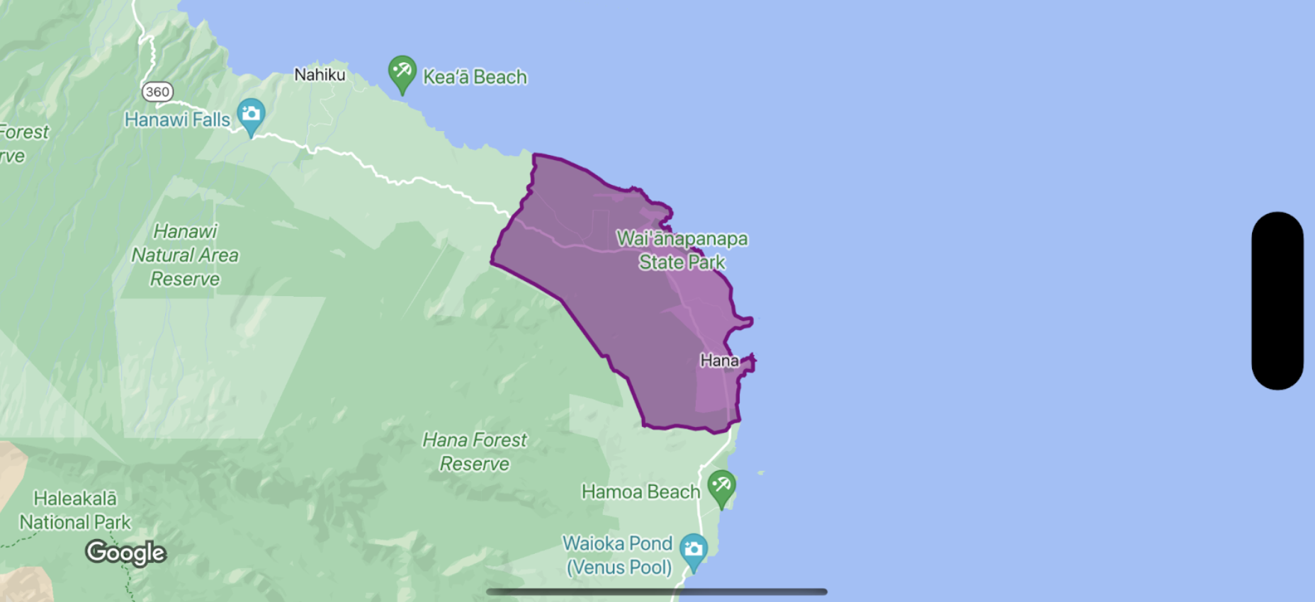
let mapView = GMSMapView(frame: .zero, mapID: GMSMapID(identifier: \"YOUR_MAP_ID\"), camera: GMSCameraPosition(latitude: 20.773, longitude: -156.01, zoom: 12))\n\nlet layer = mapView.featureLayer(of: .locality)\n\n// Define a style with purple\nlet style = FeatureStyle(fill: .purple.withAlphaComponent(0.5), stroke: .purple, strokeWidth: 3.0)\n\n// Apply the style to a single boundary.\nlayer.style = { ($0.placeID == \"ChIJ0zQtYiWsVHkRk8lRoB1RNPo\"/* Hana, HI */) ? style : nil }\n```\n\nObjective-C \n\n```objective-c\nGMSMapView *mapView = [GMSMapView mapWithFrame:CGRectZero mapID:[GMSMapID mapIDWithIdentifier:@\"MAP_ID\"] camera:[GMSCameraPosition cameraWithLatitude: 20.773 longitude: -156.01 zoom:12]];\n\nGMSFeatureLayer\u003cGMSPlaceFeature *\u003e *layer = [mapView featureLayerOfFeatureType:GMSFeatureTypeLocality];\n\n// Define a style with purple fill and border.\nGMSFeatureStyle *style = [GMSFeatureStyle styleWithFillColor:[[UIColor purpleColor] colorWithAlphaComponent:0.5] strokeColor:[UIColor purpleColor] strokeWidth:3.0];\n\n// Apply the style to a single boundary.\nlayer.style = ^(GMSPlaceFeature *feature) {\n return [feature.placeID isEqual:@\"ChIJ0zQtYiWsVHkRk8lRoB1RNPo\"/* Hana, HI */] ? style : nil;\n};\n```"]]