إخفاء ميزات الخريطة باستخدام التصميم
تنظيم صفحاتك في مجموعات
يمكنك حفظ المحتوى وتصنيفه حسب إعداداتك المفضّلة.
اختيار النظام الأساسي:
Android
iOS
JavaScript
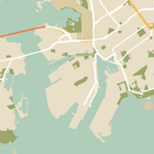
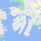
بالإضافة إلى تغيير نمط العناصر على الخريطة، يمكنك أيضًا إخفاءها تمامًا. يوضّح لك هذا المثال كيفية إخفاء نقاط الاهتمام الخاصة بالأنشطة التجارية
ورموز وسائل النقل العام على خريطتك.
لا يمكن تطبيق الأنماط إلا على نوع الخريطة kGMSTypeNormal
.
تطبيق الأنماط على خريطتك
لتطبيق أنماط خرائط مخصّصة على خريطة، استدعِ الدالة GMSMapStyle(...)
لإنشاء مثيل GMSMapStyle
، مع تمرير عنوان URL لملف JSON محلي أو سلسلة JSON تحتوي على تعريفات الأنماط. عيِّن مثيل GMSMapStyle
للسمة mapStyle
الخاصة بالخريطة.
استخدام ملف JSON
توضّح الأمثلة التالية كيفية طلب GMSMapStyle(...)
وتمرير عنوان URL لملف محلي:
يفترض نموذج الرمز البرمجي التالي أنّ مشروعك يحتوي على ملف باسم style.json
:
Swift
import GoogleMaps
class MapStyling: UIViewController {
// Set the status bar style to complement night-mode.
override var preferredStatusBarStyle: UIStatusBarStyle {
return .lightContent
}
override func loadView() {
let camera = GMSCameraPosition.camera(withLatitude: -33.86, longitude: 151.20, zoom: 14.0)
let mapView = GMSMapView.map(withFrame: CGRect.zero, camera: camera)
do {
// Set the map style by passing the URL of the local file.
if let styleURL = Bundle.main.url(forResource: "style", withExtension: "json") {
mapView.mapStyle = try GMSMapStyle(contentsOfFileURL: styleURL)
} else {
NSLog("Unable to find style.json")
}
} catch {
NSLog("One or more of the map styles failed to load. \(error)")
}
self.view = mapView
}
}
Objective-C
#import "MapStyling.h"
@import GoogleMaps;
@interface MapStyling ()
@end
@implementation MapStyling
// Set the status bar style to complement night-mode.
- (UIStatusBarStyle)preferredStatusBarStyle {
return UIStatusBarStyleLightContent;
}
- (void)loadView {
GMSCameraPosition *camera = [GMSCameraPosition cameraWithLatitude:-33.86
longitude:151.20
zoom:12];
GMSMapView *mapView = [GMSMapView mapWithFrame:CGRectZero camera:camera];
mapView.myLocationEnabled = YES;
NSBundle *mainBundle = [NSBundle mainBundle];
NSURL *styleUrl = [mainBundle URLForResource:@"style" withExtension:@"json"];
NSError *error;
// Set the map style by passing the URL for style.json.
GMSMapStyle *style = [GMSMapStyle styleWithContentsOfFileURL:styleUrl error:&error];
if (!style) {
NSLog(@"The style definition could not be loaded: %@", error);
}
mapView.mapStyle = style;
self.view = mapView;
}
@end
لتحديد خيارات النمط، أضِف ملفًا جديدًا إلى مشروعك باسم style.json
،
وألصِق بيان نمط JSON التالي لإخفاء نقاط الاهتمام الخاصة بالأنشطة التجارية ورموز النقل العام:
إظهار/إخفاء ملف JSON
[
{
"featureType": "poi.business",
"elementType": "all",
"stylers": [
{
"visibility": "off"
}
]
},
{
"featureType": "transit",
"elementType": "labels.icon",
"stylers": [
{
"visibility": "off"
}
]
}
]
استخدام مورد سلسلة
تعرض الأمثلة التالية عملية استدعاء GMSMapStyle()
وتمرير سلسلة
مصدر:
Swift
class MapStylingStringResource: UIViewController {
let MapStyle = "JSON_STYLE_GOES_HERE"
// Set the status bar style to complement night-mode.
override var preferredStatusBarStyle: UIStatusBarStyle {
return .lightContent
}
override func loadView() {
let camera = GMSCameraPosition.camera(withLatitude: -33.86, longitude: 151.20, zoom: 14.0)
let mapView = GMSMapView.map(withFrame: CGRect.zero, camera: camera)
do {
// Set the map style by passing a valid JSON string.
mapView.mapStyle = try GMSMapStyle(jsonString: MapStyle)
} catch {
NSLog("One or more of the map styles failed to load. \(error)")
}
self.view = mapView
}
}
Objective-C
@implementation MapStylingStringResource
// Paste the JSON string to use.
static NSString *const kMapStyle = @"JSON_STYLE_GOES_HERE";
// Set the status bar style to complement night-mode.
- (UIStatusBarStyle)preferredStatusBarStyle {
return UIStatusBarStyleLightContent;
}
- (void)loadView {
GMSCameraPosition *camera = [GMSCameraPosition cameraWithLatitude:-33.86
longitude:151.20
zoom:12];
GMSMapView *mapView = [GMSMapView mapWithFrame:CGRectZero camera:camera];
mapView.myLocationEnabled = YES;
NSError *error;
// Set the map style by passing a valid JSON string.
GMSMapStyle *style = [GMSMapStyle styleWithJSONString:kMapStyle error:&error];
if (!style) {
NSLog(@"The style definition could not be loaded: %@", error);
}
mapView.mapStyle = style;
self.view = mapView;
}
@end
يخفي تعريف النمط التالي نقاط الاهتمام الخاصة بالأنشطة التجارية ورموز وسائل النقل العام. الصِق سلسلة الأنماط التالية كقيمة للمتغير kMapStyle
:
إظهار/إخفاء ملف JSON
@"["
@" {"
@" \"featureType\": \"poi.business\","
@" \"elementType\": \"all\","
@" \"stylers\": ["
@" {"
@" \"visibility\": \"off\""
@" }"
@" ]"
@" },"
@" {"
@" \"featureType\": \"transit\","
@" \"elementType\": \"labels.icon\","
@" \"stylers\": ["
@" {"
@" \"visibility\": \"off\""
@" }"
@" ]"
@" }"
@"]"
تعريفات نمط JSON
تستخدِم الخرائط ذات الأنماط مفهومَين لتطبيق الألوان والتغييرات الأخرى على الأنماط في الخريطة، وهما:
- تحدّد أدوات الاختيار المكوّنات الجغرافية التي يمكنك
تنسيقها على الخريطة. وتشمل هذه البيانات الطرق والحدائق والمسطحات المائية وغيرها، بالإضافة إلى تصنيفاتها. تتضمّن أدوات الاختيار ميزات وعناصر، ويتم تحديدها كسمتَي
featureType
وelementType
.
- أدوات التنسيق هي خصائص اللون ومستوى الظهور التي يمكنك تطبيقها على عناصر الخريطة. وتحدّد هذه المساحات اللون المعروض من خلال مزيج من قيم التدرج اللوني واللون والسطوع/غاما.
راجِع مرجع الأنماط للحصول على وصف تفصيلي لخيارات أنماط JSON.
استخدِم معالج الأنماط في "منصة خرائط Google" كطريقة سريعة لإنشاء عنصر JSON خاص بالأنماط. تتوافق حزمة تطوير البرامج بالاستناد إلى بيانات "خرائط Google" لتطبيقات iOS مع تعريفات الأنماط نفسها المتوافقة مع واجهة برمجة تطبيقات JavaScript للخرائط.
عيّنات التعليمات البرمجية الكاملة
يتضمّن مستودع ApiDemos على GitHub عيّنات توضّح كيفية استخدام الأنماط.
إنّ محتوى هذه الصفحة مرخّص بموجب ترخيص Creative Commons Attribution 4.0 ما لم يُنصّ على خلاف ذلك، ونماذج الرموز مرخّصة بموجب ترخيص Apache 2.0. للاطّلاع على التفاصيل، يُرجى مراجعة سياسات موقع Google Developers. إنّ Java هي علامة تجارية مسجَّلة لشركة Oracle و/أو شركائها التابعين.
تاريخ التعديل الأخير: 2025-08-31 (حسب التوقيت العالمي المتفَّق عليه)
[null,null,["تاريخ التعديل الأخير: 2025-08-31 (حسب التوقيت العالمي المتفَّق عليه)"],[[["\u003cp\u003eLearn how to hide map features like business POIs and transit icons using the Google Maps SDK for iOS.\u003c/p\u003e\n"],["\u003cp\u003eApply custom styles by providing a local JSON file or a JSON string containing style definitions to the \u003ccode\u003emapStyle\u003c/code\u003e property of your map.\u003c/p\u003e\n"],["\u003cp\u003eUtilize the \u003ccode\u003efeatureType\u003c/code\u003e and \u003ccode\u003eelementType\u003c/code\u003e properties in your JSON to select the specific map components you want to style.\u003c/p\u003e\n"],["\u003cp\u003eControl the visibility and color of map elements through \u003ccode\u003estylers\u003c/code\u003e in your JSON style declaration.\u003c/p\u003e\n"],["\u003cp\u003eExplore the Maps Platform Styling Wizard for a user-friendly way to generate JSON styling objects for your map.\u003c/p\u003e\n"]]],["To style maps, you can hide features like business POIs and transit icons. Apply styles using `GMSMapStyle`, either with a local JSON file URL or a JSON string. Create a `style.json` file, and use selectors (features and elements) and stylers (visibility) to define map styles. Use the `mapStyle` property on the map to apply styles. Alternatively, you can define a JSON string with the same style options. You can utilize the [Maps Platform Styling Wizard](https://mapstyle.withgoogle.com) for an efficient JSON style object creation.\n"],null,["Select platform: [Android](/maps/documentation/android-sdk/hiding-features \"View this page for the Android platform docs.\") [iOS](/maps/documentation/ios-sdk/hiding-features \"View this page for the iOS platform docs.\") [JavaScript](/maps/documentation/javascript/json-styling-overview \"View this page for the JavaScript platform docs.\")\n\n\u003cbr /\u003e\n\nAs well as changing the style of features on the map, you can also hide them\nentirely. This example shows you how to hide business points of interest (POIs)\nand public transit icons on your map.\n\nStyling works only on the `kGMSTypeNormal` map type.\n\nApplying styles to your map\n\nTo apply custom map styles to a map, call `GMSMapStyle(...)` to create a\n`GMSMapStyle` instance, passing in a URL for a local JSON file, or a JSON\nstring containing style definitions. Assign the `GMSMapStyle` instance to the\n`mapStyle` property of the map.\n\nUsing a JSON file\n\nThe following examples show calling `GMSMapStyle(...)` and passing a URL for a\nlocal file:\n\nThe following code sample assumes your project contains a file named\n`style.json`:\n\n\nSwift \n\n```swift\nimport GoogleMaps\n\nclass MapStyling: UIViewController {\n\n // Set the status bar style to complement night-mode.\n override var preferredStatusBarStyle: UIStatusBarStyle {\n return .lightContent\n }\n\n override func loadView() {\n let camera = GMSCameraPosition.camera(withLatitude: -33.86, longitude: 151.20, zoom: 14.0)\n let mapView = GMSMapView.map(withFrame: CGRect.zero, camera: camera)\n\n do {\n // Set the map style by passing the URL of the local file.\n if let styleURL = Bundle.main.url(forResource: \"style\", withExtension: \"json\") {\n mapView.mapStyle = try GMSMapStyle(contentsOfFileURL: styleURL)\n } else {\n NSLog(\"Unable to find style.json\")\n }\n } catch {\n NSLog(\"One or more of the map styles failed to load. \\(error)\")\n }\n\n self.view = mapView\n }\n}\n \n```\n\nObjective-C \n\n```objective-c\n#import \"MapStyling.h\"\n@import GoogleMaps;\n\n@interface MapStyling ()\n\n@end\n\n@implementation MapStyling\n\n// Set the status bar style to complement night-mode.\n- (UIStatusBarStyle)preferredStatusBarStyle {\n return UIStatusBarStyleLightContent;\n}\n\n- (void)loadView {\n GMSCameraPosition *camera = [GMSCameraPosition cameraWithLatitude:-33.86\n longitude:151.20\n zoom:12];\n GMSMapView *mapView = [GMSMapView mapWithFrame:CGRectZero camera:camera];\n mapView.myLocationEnabled = YES;\n\n NSBundle *mainBundle = [NSBundle mainBundle];\n NSURL *styleUrl = [mainBundle URLForResource:@\"style\" withExtension:@\"json\"];\n NSError *error;\n\n // Set the map style by passing the URL for style.json.\n GMSMapStyle *style = [GMSMapStyle styleWithContentsOfFileURL:styleUrl error:&error];\n\n if (!style) {\n NSLog(@\"The style definition could not be loaded: %@\", error);\n }\n\n mapView.mapStyle = style;\n self.view = mapView;\n}\n\n@end\n \n```\n\n\u003cbr /\u003e\n\nTo define the style options, add a new file to your project named `style.json`,\nand paste the following JSON style declaration to hide business points of\ninterest (POIs) and public transit icons:\nShow/Hide the JSON. \n\n```text\n[\n {\n \"featureType\": \"poi.business\",\n \"elementType\": \"all\",\n \"stylers\": [\n {\n \"visibility\": \"off\"\n }\n ]\n },\n {\n \"featureType\": \"transit\",\n \"elementType\": \"labels.icon\",\n \"stylers\": [\n {\n \"visibility\": \"off\"\n }\n ]\n }\n]\n```\n\nUsing a string resource\n\nThe following examples show calling `GMSMapStyle()` and passing a string\nresource:\n\n\nSwift \n\n```swift\nclass MapStylingStringResource: UIViewController {\n\n let MapStyle = \"JSON_STYLE_GOES_HERE\"\n\n // Set the status bar style to complement night-mode.\n override var preferredStatusBarStyle: UIStatusBarStyle {\n return .lightContent\n }\n\n override func loadView() {\n let camera = GMSCameraPosition.camera(withLatitude: -33.86, longitude: 151.20, zoom: 14.0)\n let mapView = GMSMapView.map(withFrame: CGRect.zero, camera: camera)\n\n do {\n // Set the map style by passing a valid JSON string.\n mapView.mapStyle = try GMSMapStyle(jsonString: MapStyle)\n } catch {\n NSLog(\"One or more of the map styles failed to load. \\(error)\")\n }\n\n self.view = mapView\n }\n}\n \n```\n\nObjective-C \n\n```objective-c\n@implementation MapStylingStringResource\n\n// Paste the JSON string to use.\nstatic NSString *const kMapStyle = @\"JSON_STYLE_GOES_HERE\";\n\n// Set the status bar style to complement night-mode.\n- (UIStatusBarStyle)preferredStatusBarStyle {\n return UIStatusBarStyleLightContent;\n}\n\n- (void)loadView {\n GMSCameraPosition *camera = [GMSCameraPosition cameraWithLatitude:-33.86\n longitude:151.20\n zoom:12];\n GMSMapView *mapView = [GMSMapView mapWithFrame:CGRectZero camera:camera];\n mapView.myLocationEnabled = YES;\n\n NSError *error;\n\n // Set the map style by passing a valid JSON string.\n GMSMapStyle *style = [GMSMapStyle styleWithJSONString:kMapStyle error:&error];\n\n if (!style) {\n NSLog(@\"The style definition could not be loaded: %@\", error);\n }\n\n mapView.mapStyle = style;\n self.view = mapView;\n}\n\n@end\n \n```\n\n\u003cbr /\u003e\n\nThe following style declaration hides business points of interest (POIs) and\npublic transit icons. Paste the following style string as the value of\nthe `kMapStyle` variable:\nShow/Hide the JSON. \n\n```objective-c\n@\"[\"\n@\" {\"\n@\" \\\"featureType\\\": \\\"poi.business\\\",\"\n@\" \\\"elementType\\\": \\\"all\\\",\"\n@\" \\\"stylers\\\": [\"\n@\" {\"\n@\" \\\"visibility\\\": \\\"off\\\"\"\n@\" }\"\n@\" ]\"\n@\" },\"\n@\" {\"\n@\" \\\"featureType\\\": \\\"transit\\\",\"\n@\" \\\"elementType\\\": \\\"labels.icon\\\",\"\n@\" \\\"stylers\\\": [\"\n@\" {\"\n@\" \\\"visibility\\\": \\\"off\\\"\"\n@\" }\"\n@\" ]\"\n@\" }\"\n@\"]\"\n```\n\nJSON style declarations\n\nStyled maps use two concepts to apply colors and other style changes to a\nmap:\n\n- **Selectors** specify the geographic components that you can style on the map. These include roads, parks, bodies of water, and more, as well as their labels. The selectors include *features* and *elements* , specified as `featureType` and `elementType` properties.\n- **Stylers** are color and visibility properties that you can apply to map elements. They define the displayed color through a combination of hue, color, and lightness/gamma values.\n\nSee the [style reference](/maps/documentation/ios-sdk/style-reference) for a detailed description of the\nJSON styling options.\n\nMaps Platform Styling Wizard \n[](https://mapstyle.withgoogle.com) \n[](https://mapstyle.withgoogle.com) \n[](https://mapstyle.withgoogle.com)[](https://mapstyle.withgoogle.com/) \n[](https://mapstyle.withgoogle.com/) \n[](https://mapstyle.withgoogle.com/) \n[](https://mapstyle.withgoogle.com/) \n[](https://mapstyle.withgoogle.com/) \n[](https://mapstyle.withgoogle.com/) \n[Create\ncustom styles for the Google Maps Platform APIs](https://mapstyle.withgoogle.com)\n\nUse the [Maps Platform Styling Wizard](https://mapstyle.withgoogle.com) as a quick way\nto generate a JSON styling object. The Maps SDK for iOS supports the\nsame style declarations as the Maps JavaScript API.\n\nFull code samples\n\nThe [ApiDemos repository](https://github.com/googlemaps-samples/maps-sdk-for-ios-samples) on GitHub includes\nsamples that demonstrate the use of styling."]]