
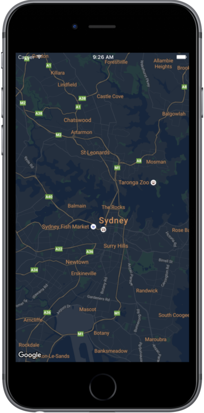
本页是设置地图样式的快速指南,其中以夜间模式为例。
概览
您可以使用样式选项自定义标准 Google 地图样式的外观风格,更改道路、公园、商家和其他地图注点等地图项的视觉显示效果。也就是说,您可以突出地图的特定组件,或让地图与应用的样式协调一致。
样式设置仅适用于 kGMSTypeNormal 地图类型。
将样式应用到地图
如需将自定义地图样式应用于地图,请调用 GMSMapStyle(...) 以创建 GMSMapStyle 实例,并传入本地 JSON 文件的网址或包含样式定义的 JSON 字符串。将 GMSMapStyle 实例分配给地图的 mapStyle 属性。
使用 JSON 文件
以下示例展示了如何调用 GMSMapStyle(...) 并传递本地文件的网址:
Swift
import GoogleMaps

class MapStyling: UIViewController {

  // Set the status bar style to complement night-mode.
  override var preferredStatusBarStyle: UIStatusBarStyle {
    return .lightContent
  }

  override func loadView() {
    let camera = GMSCameraPosition.camera(withLatitude: -33.86, longitude: 151.20, zoom: 14.0)
    let mapView = GMSMapView.map(withFrame: CGRect.zero, camera: camera)

    do {
      // Set the map style by passing the URL of the local file.
      if let styleURL = Bundle.main.url(forResource: "style", withExtension: "json") {
        mapView.mapStyle = try GMSMapStyle(contentsOfFileURL: styleURL)
      } else {
        NSLog("Unable to find style.json")
      }
    } catch {
      NSLog("One or more of the map styles failed to load. \(error)")
    }

    self.view = mapView
  }
}
Objective-C
#import "MapStyling.h"
@import GoogleMaps;

@interface MapStyling ()

@end

@implementation MapStyling

// Set the status bar style to complement night-mode.
- (UIStatusBarStyle)preferredStatusBarStyle {
  return UIStatusBarStyleLightContent;
}

- (void)loadView {
  GMSCameraPosition *camera = [GMSCameraPosition cameraWithLatitude:-33.86
                                                          longitude:151.20
                                                               zoom:12];
  GMSMapView *mapView = [GMSMapView mapWithFrame:CGRectZero camera:camera];
  mapView.myLocationEnabled = YES;

  NSBundle *mainBundle = [NSBundle mainBundle];
  NSURL *styleUrl = [mainBundle URLForResource:@"style" withExtension:@"json"];
  NSError *error;

  // Set the map style by passing the URL for style.json.
  GMSMapStyle *style = [GMSMapStyle styleWithContentsOfFileURL:styleUrl error:&error];

  if (!style) {
    NSLog(@"The style definition could not be loaded: %@", error);
  }

  mapView.mapStyle = style;
  self.view = mapView;
}

@end
如需定义样式选项,请向您的项目添加一个名为 style.json 的新文件,然后粘贴以下用于夜间模式样式的 JSON 样式声明:
使用字符串资源
以下示例展示了如何调用 GMSMapStyle(...) 并传递字符串资源:
Swift
class MapStylingStringResource: UIViewController {

  let MapStyle = "JSON_STYLE_GOES_HERE"

  // Set the status bar style to complement night-mode.
  override var preferredStatusBarStyle: UIStatusBarStyle {
    return .lightContent
  }

  override func loadView() {
    let camera = GMSCameraPosition.camera(withLatitude: -33.86, longitude: 151.20, zoom: 14.0)
    let mapView = GMSMapView.map(withFrame: CGRect.zero, camera: camera)

    do {
      // Set the map style by passing a valid JSON string.
      mapView.mapStyle = try GMSMapStyle(jsonString: MapStyle)
    } catch {
      NSLog("One or more of the map styles failed to load. \(error)")
    }

    self.view = mapView
  }
}
Objective-C
@implementation MapStylingStringResource

// Paste the JSON string to use.
static NSString *const kMapStyle = @"JSON_STYLE_GOES_HERE";

// Set the status bar style to complement night-mode.
- (UIStatusBarStyle)preferredStatusBarStyle {
  return UIStatusBarStyleLightContent;
}

- (void)loadView {
  GMSCameraPosition *camera = [GMSCameraPosition cameraWithLatitude:-33.86
                                                          longitude:151.20
                                                               zoom:12];
  GMSMapView *mapView = [GMSMapView mapWithFrame:CGRectZero camera:camera];
  mapView.myLocationEnabled = YES;

  NSError *error;

  // Set the map style by passing a valid JSON string.
  GMSMapStyle *style = [GMSMapStyle styleWithJSONString:kMapStyle error:&error];

  if (!style) {
    NSLog(@"The style definition could not be loaded: %@", error);
  }

  mapView.mapStyle = style;
  self.view = mapView;
}

@end
如需定义样式选项,请粘贴以下样式字符串作为 kMapStyle 变量的值:
JSON 样式声明
自定样式的地图利用以下两种概念,将颜色和其他样式更改应用到地图:
- 选择器:指定可以在地图上设置样式的地理区域组件,包括道路、公园、水体等项目以及它们的标签。选择器包括地图项和元素,分别以
featureType和elementType属性来表示。 - 样式器:可应用于地图元素的颜色和可见性属性,通过色调、颜色、亮度和灰度系数值的组合来定义显示的颜色。
有关 JSON 样式设置选项的详细说明,请参阅样式参考。
Maps Platform 样式设置向导


使用 Maps Platform 样式设置向导可以快速生成 JSON 样式设置对象。Maps SDK for iOS 支持与 Maps JavaScript API 相同的样式声明。
完整代码示例
GitHub 上的 ApiDemos 代码库包含相关示例,展示了如何使用样式设置。
下一步
了解如何通过样式设置来隐藏地图上的地图项。