Haritaya 3D model ekleme
Koleksiyonlar ile düzeninizi koruyun
İçeriği tercihlerinize göre kaydedin ve kategorilere ayırın.
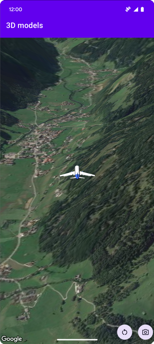
Aşağıdaki kod örneğinde, addModel
yöntemini çağırarak 3D modelin nasıl ekleneceği ve 3D uzayda nasıl konumlandırılacağı gösterilmektedir. Bu kod örneğini kullanmak için Kurulum ve Uygulamanıza 3D harita ekleme bölümündeki talimatları uygulayarak Android Studio projenizi temel bir 3D harita ile ayarlayın. Ardından, aşağıdaki kodu MainActivity.kt
dosyasına ekleyin:
// Add imports and define constants
import com.google.android.gms.maps3d.model.latLngAltitude
val PLANE_URL = "https://storage.googleapis.com/gmp-maps-demos/p3d-map/assets/Airplane.glb"
val PLANE_SCALE = 0.05
// Add to the onMap3DViewReady method, after the googleMap3D object has been initialized
googleMap3D.setCamera(
camera {
center = latLngAltitude {
latitude = 47.133971
longitude = 11.333161
altitude = 2200.0
}
heading = 221.0
tilt = 65.0
range = 1_200.0
}
)
googleMap3D.addModel(
modelOptions {
id = "plane_model"
position = latLngAltitude {
latitude = 47.133971
longitude = 11.333161
altitude = 2200.0
}
altitudeMode = AltitudeMode.ABSOLUTE
orientation = orientation {
heading = 41.5
tilt = -90.0
roll = 0.0
}
url = PLANE_URL
scale = vector3D {
x = PLANE_SCALE
y = PLANE_SCALE
z = PLANE_SCALE
}
}
)
Aksi belirtilmediği sürece bu sayfanın içeriği Creative Commons Atıf 4.0 Lisansı altında ve kod örnekleri Apache 2.0 Lisansı altında lisanslanmıştır. Ayrıntılı bilgi için Google Developers Site Politikaları'na göz atın. Java, Oracle ve/veya satış ortaklarının tescilli ticari markasıdır.
Son güncelleme tarihi: 2025-08-31 UTC.
[null,null,["Son güncelleme tarihi: 2025-08-31 UTC."],[],[],null,["# Add a 3D model to a map\n\nSelect platform: [Android](/maps/documentation/maps-3d/android-sdk/add-3d-models \"View this page for the Android platform docs.\") [iOS](/maps/documentation/maps-3d/ios-sdk/add-3d-models \"View this page for the iOS platform docs.\") [JavaScript](/maps/documentation/javascript/3d/models \"View this page for the JavaScript platform docs.\")\n\n\u003cbr /\u003e\n\n| This product or feature is Experimental (pre-GA). Pre-GA products and features might have limited support, and changes to pre-GA products and features might not be compatible with other pre-GA versions. Pre-GA Offerings are covered by the [Google\n| Maps Platform Service Specific Terms](https://cloud.google.com/maps-platform/terms/maps-service-terms). For more information, see the [launch stage descriptions](/maps/launch-stages).\n\n\nThe following code sample\ndemonstrates how to add a 3D model and position it in 3D space by calling the\n[`addModel`](/maps/documentation/maps-3d/android-sdk/reference/com/google/android/gms/maps3d/GoogleMap3D#addModel(com.google.android.gms.maps3d.model.ModelOptions))\nmethod. To use this code sample, follow the instructions in\n[Setup](/maps/documentation/maps-3d/android-sdk/setup) and\n[Add a 3D map to your app](/maps/documentation/maps-3d/android-sdk/add-a-3d-map) to set\nup your Android Studio project with a basic 3D map. Then, add the following code to the\n**`MainActivity.kt`** file:\n\n```kotlin\n// Add imports and define constants\nimport com.google.android.gms.maps3d.model.latLngAltitude\nval PLANE_URL = \"https://storage.googleapis.com/gmp-maps-demos/p3d-map/assets/Airplane.glb\"\nval PLANE_SCALE = 0.05\n\n// Add to the onMap3DViewReady method, after the googleMap3D object has been initialized\ngoogleMap3D.setCamera(\n camera {\n center = latLngAltitude {\n latitude = 47.133971\n longitude = 11.333161\n altitude = 2200.0\n }\n heading = 221.0\n tilt = 65.0\n range = 1_200.0\n }\n)\n\ngoogleMap3D.addModel(\n modelOptions {\n id = \"plane_model\"\n position = latLngAltitude {\n latitude = 47.133971\n longitude = 11.333161\n altitude = 2200.0\n }\n altitudeMode = AltitudeMode.ABSOLUTE\n orientation = orientation {\n heading = 41.5\n tilt = -90.0\n roll = 0.0\n }\n url = PLANE_URL\n scale = vector3D {\n x = PLANE_SCALE\n y = PLANE_SCALE\n z = PLANE_SCALE\n }\n }\n)\n```"]]