הוספת קו מרובע למפה
קל לארגן דפים בעזרת אוספים
אפשר לשמור ולסווג תוכן על סמך ההעדפות שלך.
בדוגמת הקוד הבאה אפשר לראות איך מוסיפים קו פוליגוני וממקמים אותו במרחב תלת-ממדי באמצעות הפעלת השיטה addPolyline
. כדי להשתמש בדוגמת הקוד הזו, צריך לפעול לפי ההוראות שבקטעים הגדרה והוספת מפה תלת-ממדית לאפליקציה כדי להגדיר את פרויקט Android Studio עם מפה תלת-ממדית בסיסית. אחר כך מוסיפים את הקוד הבא לקובץ MainActivity.kt
:
// Add imports
import com.google.android.gms.maps3d.model.latLngAltitude
...
// Add to the onMap3DViewReady method, after the googleMap3D object has been initialized
googleMap3D.setCamera(
camera {
center = latLngAltitude {
latitude = 40.029349
longitude = -105.300354
altitude = 1833.9
}
heading = 326.0
tilt = 75.0
range = 3757.0
}
)
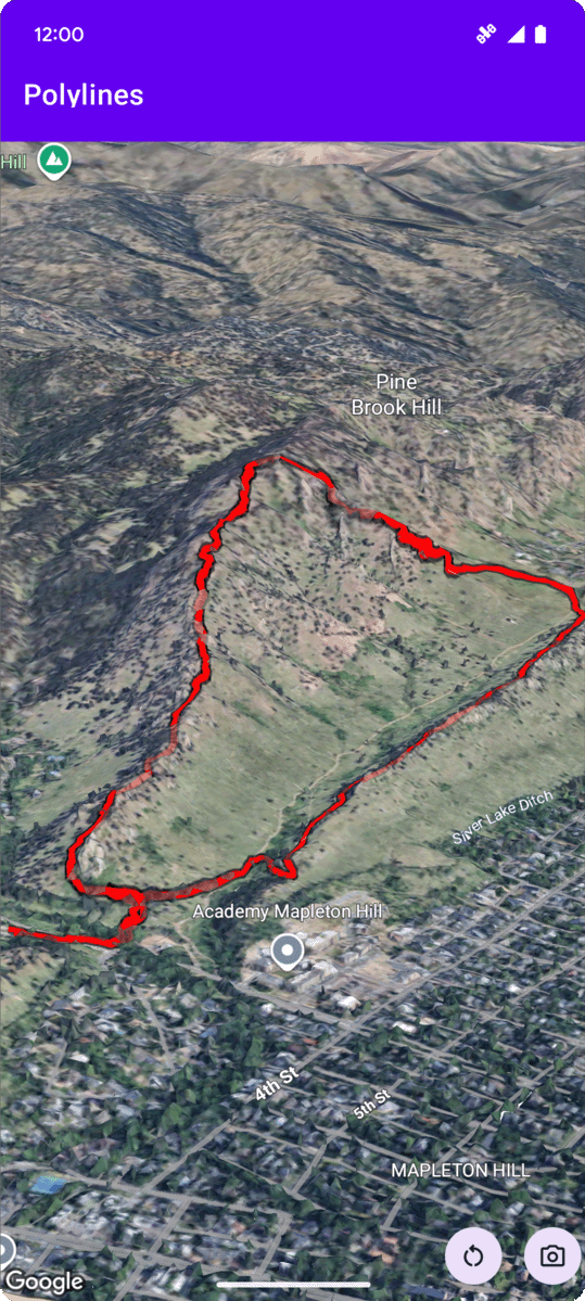
internal val trailLocations = """
40.0201040, -105.2976640
40.0201080, -105.2976450
40.0201640, -105.2975120
40.0202200, -105.2973740
40.0202500, -105.2972760
40.0202960, -105.2971410
40.0203080, -105.2970990
40.0203320, -105.2970070
40.0203640, -105.2969400
40.0203710, -105.2969250
40.0203770, -105.2969220
40.0203910, -105.2969130
40.0203940, -105.2969120
40.0204200, -105.2969130
40.0204630, -105.2968910
40.0205270, -105.2968280
40.0206030, -105.2967570
40.0206590, -105.2966100
40.0206990, -105.2964870
""".trimIndent().split("\n").map {
val (lat, lng) = it.split(",")
latLngAltitude {
latitude = lat.toDouble()
longitude = lng.toDouble()
altitude = 0.0 // The trail will be clamped to the ground
}
}
val trailPolylineOptions = polylineOptions {
coordinates = trailLocations
strokeColor = Color.RED
strokeWidth = 7.0
altitudeMode = AltitudeMode.CLAMP_TO_GROUND
zIndex = 5
drawsOccludedSegments = true
}
googleMap3D.addPolyline(trailPolylineOptions)
אלא אם צוין אחרת, התוכן של דף זה הוא ברישיון Creative Commons Attribution 4.0 ודוגמאות הקוד הן ברישיון Apache 2.0. לפרטים, ניתן לעיין במדיניות האתר Google Developers. Java הוא סימן מסחרי רשום של חברת Oracle ו/או של השותפים העצמאיים שלה.
עדכון אחרון: 2025-08-31 (שעון UTC).
[null,null,["עדכון אחרון: 2025-08-31 (שעון UTC)."],[],[],null,["# Add a polyline to a map\n\nSelect platform: [Android](/maps/documentation/maps-3d/android-sdk/add-polylines \"View this page for the Android platform docs.\") [iOS](/maps/documentation/maps-3d/ios-sdk/add-polylines \"View this page for the iOS platform docs.\") [JavaScript](/maps/documentation/javascript/3d/shapes-lines \"View this page for the JavaScript platform docs.\")\n\n\u003cbr /\u003e\n\n| This product or feature is Experimental (pre-GA). Pre-GA products and features might have limited support, and changes to pre-GA products and features might not be compatible with other pre-GA versions. Pre-GA Offerings are covered by the [Google\n| Maps Platform Service Specific Terms](https://cloud.google.com/maps-platform/terms/maps-service-terms). For more information, see the [launch stage descriptions](/maps/launch-stages).\n\n\nThe following code sample\ndemonstrates how to add a polyline and position it in 3D space by calling the\n[`addPolyline`](/maps/documentation/maps-3d/android-sdk/reference/com/google/android/gms/maps3d/GoogleMap3D#addPolyline(com.google.android.gms.maps3d.model.PolylineOptions))\nmethod. To use this code sample, follow the instructions in\n[Setup](/maps/documentation/maps-3d/android-sdk/setup) and\n[Add a 3D map to your app](/maps/documentation/maps-3d/android-sdk/add-a-3d-map) to set\nup your Android Studio project with a basic 3D map. Then, add the following code to the\n**`MainActivity.kt`** file: \n\n```kotlin\n// Add imports\nimport com.google.android.gms.maps3d.model.latLngAltitude\n\n...\n\n// Add to the onMap3DViewReady method, after the googleMap3D object has been initialized\ngoogleMap3D.setCamera(\n camera {\n center = latLngAltitude {\n latitude = 40.029349\n longitude = -105.300354\n altitude = 1833.9\n }\n heading = 326.0\n tilt = 75.0\n range = 3757.0\n }\n)\ninternal val trailLocations = \"\"\"\n 40.0201040, -105.2976640\n 40.0201080, -105.2976450\n 40.0201640, -105.2975120\n 40.0202200, -105.2973740\n 40.0202500, -105.2972760\n 40.0202960, -105.2971410\n 40.0203080, -105.2970990\n 40.0203320, -105.2970070\n 40.0203640, -105.2969400\n 40.0203710, -105.2969250\n 40.0203770, -105.2969220\n 40.0203910, -105.2969130\n 40.0203940, -105.2969120\n 40.0204200, -105.2969130\n 40.0204630, -105.2968910\n 40.0205270, -105.2968280\n 40.0206030, -105.2967570\n 40.0206590, -105.2966100\n 40.0206990, -105.2964870\n\"\"\".trimIndent().split(\"\\n\").map {\n val (lat, lng) = it.split(\",\")\n latLngAltitude {\n latitude = lat.toDouble()\n longitude = lng.toDouble()\n altitude = 0.0 // The trail will be clamped to the ground\n }\n}\n\nval trailPolylineOptions = polylineOptions {\n coordinates = trailLocations\n strokeColor = Color.RED\n strokeWidth = 7.0\n altitudeMode = AltitudeMode.CLAMP_TO_GROUND\n zIndex = 5\n drawsOccludedSegments = true\n}\n\ngoogleMap3D.addPolyline(trailPolylineOptions)\n```"]]