کاربران می توانند زوم، شیب، موقعیت و چرخش دوربین را با استفاده از ژست های حرکتی روی نقشه کنترل کنند. همچنین می توانید دوربین را به صورت برنامه ای پیکربندی کنید.
موقعیت دوربین
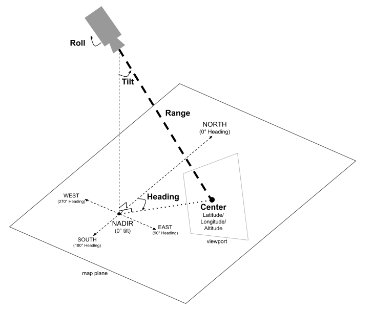
نمای نقشه به صورت دوربینی مدلسازی میشود که به یک نقطه خاص در یک فضای سه بعدی نگاه میکند. موقعیت و جهت دوربین (و در نتیجه رندر نقشه) با ویژگیهای زیر مشخص میشود: مرکز (مکانی در عرض/طول/طول/ارتفاع که دوربین به آن نگاه میکند)، سمت، شیب، برد و چرخش.
مرکز (طول و عرض جغرافیایی/ارتفاع)
مرکز نقطه خاصی را در فضای سه بعدی که دوربین در حال مشاهده است، مشخص می کند. این با استفاده از مقادیر برای عرض جغرافیایی، طول جغرافیایی و ارتفاع مشخص می شود. این امکان قرارگیری دقیق نقطه کانونی دوربین در سه بعدی را فراهم می کند.
عرض جغرافیایی می تواند بین 90- تا 90 درجه باشد. مقادیر بالاتر یا پایینتر از این محدوده به نزدیکترین مقدار در این محدوده گیره میشوند. برای مثال، با تعیین عرض جغرافیایی 100، مقدار 90 تنظیم می شود. ارتفاع بر حسب متر از سطح دریا مشخص می شود.
سرفصل
عنوان دوربین جهتی را که دوربین در جهت عقربههای ساعت از شمال واقعی اندازهگیری میکند، مشخص میکند. شمال با 0 درجه، شرق با 90 درجه، جنوب به 180 درجه و غرب با 270 درجه مطابقت دارد. این جهت دوربین را حول محور عمودی نقطه مرکزی تعیین می کند.
کج کردن
شیب زاویه دوربین را نسبت به محور عمودی مشخص می کند که بر حسب درجه اندازه گیری می شود. شیب 0 درجه به این معنی است که دوربین مستقیماً به سمت زمین ( نادیر ) به سمت پایین است. شیب 90 درجه به این معنی است که دوربین به صورت افقی در جهت مشخص شده توسط عنوان نشانه گرفته شده است.
محدوده
برد فاصله بین موقعیت دوربین و نقطه مرکزی که به آن نگاه می کند را بر حسب متر مشخص می کند. برد می تواند از صفر متر (خیلی نزدیک) تا شصت و سه میلیون متر متغیر باشد، که امکان مشاهده از خیلی نزدیک تا یک چشم انداز واقعاً جهانی را فراهم می کند. این به طور موثر نحوه نمایش "زوم" یا "کوچک کردن" نقشه را کنترل می کند.
رول
رول زاویه دوربین را با توجه به افق تنظیم می کند که بر حسب درجه اندازه گیری می شود. از این پارامتر می توان برای ایجاد افکت هایی مانند بانکداری در حین شبیه سازی پرواز یا حتی چرخش کامل بشکه، چرخش دوربین حول محور دید آن استفاده کرد.
کنترل دوربین
نمونه کد زیر نحوه کنترل دوربین را به صورت برنامه ای نشان می دهد.
تاریخ آخرین بهروزرسانی 2025-08-29 بهوقت ساعت هماهنگ جهانی.
[null,null,["تاریخ آخرین بهروزرسانی 2025-08-29 بهوقت ساعت هماهنگ جهانی."],[],[],null,["# Configure camera controls\n\nSelect platform: [Android](/maps/documentation/maps-3d/android-sdk/configure-camera-controls \"View this page for the Android platform docs.\") [iOS](/maps/documentation/maps-3d/ios-sdk/configure-camera-controls \"View this page for the iOS platform docs.\") [JavaScript](/maps/documentation/javascript/3d/map-controls \"View this page for the JavaScript platform docs.\")\n\n\u003cbr /\u003e\n\n| This product or feature is Experimental (pre-GA). Pre-GA products and features might have limited support, and changes to pre-GA products and features might not be compatible with other pre-GA versions. Pre-GA Offerings are covered by the [Google\n| Maps Platform Service Specific Terms](https://cloud.google.com/maps-platform/terms/maps-service-terms). For more information, see the [launch stage descriptions](/maps/launch-stages).\n\n\nUsers can control the zoom, tilt, position, and rotation of the camera using gestures on the map.\nYou can also configure the camera programmatically.\n\nThe Camera Position\n-------------------\n\nThe map view is modeled as a **camera** looking at a specific point in a 3D space.\nThe position and orientation of the camera (and hence the rendering of the map) are specified by\nthe following properties: center (a latitude/longitude/altitude location the camera is looking\nat), heading, tilt, range, and roll.\n\n### Center (Latitude/Longitude/Altitude)\n\nThe **center** defines the specific point in 3D space that the camera is observing.\nThis is\nspecified using values for latitude, longitude, and altitude. This allows for precise\npositioning of the camera's focal point in three dimensions.\n\n\nThe latitude can be between -90 and 90 degrees, inclusive. Values\nabove or below this range will be clamped to the nearest value within this range. For example,\nspecifying a latitude of 100 will set the value to 90. Longitude\nranges between -180 and 180 degrees, inclusive. Altitude is specified in meters above\nsea level.\n\n### Heading\n\nThe camera **heading** specifies the direction the camera will point, measured in\ndegrees clockwise from true North. North corresponds to 0 degrees, East to 90 degrees, South to\n180 degrees, and West to 270 degrees. This determines the orientation of the camera around the\nvertical axis of the [center point](#center_location).\n\n### Tilt\n\nThe **tilt** specifies the angle of the camera with respect to the vertical axis,\nmeasured in degrees. A tilt of 0 degrees means the camera is pointing straight down towards the\nEarth ([nadir](https://en.wikipedia.org/wiki/Nadir)). A tilt of 90\ndegrees means the camera is pointed horizontally in the direction\nspecified by the [heading](#heading_orientation).\n\n### Range\n\nThe **range** defines the distance in meters between the camera's own position and\nthe [center point](#center_location) it is looking at. The range can vary from zero\nmeters (very close up) up to sixty-three million meters, allowing for views from very close up all\nthe way to a truly global perspective. This effectively controls how \"zoomed in\" or \"zoomed out\"\nthe map appears.\n\n### Roll\n\n\nThe **roll** sets the angle of the camera with respect to the horizon,\nmeasured in degrees. This parameter can be used to create effects like banking during flight\nsimulations or even a full barrel roll, rotating the camera around its viewing axis.\n\nControlling the camera\n----------------------\n\nThe following code sample demonstrates how to control the camera programmatically. \n\n### Swift\n\n```swift\npublic static var sanFrancisco: Camera = .init(\n latitude: 37.7845812,\n longitude: -122.3660241,\n altitude: 585,\n heading: 288.0,\n tilt: 75.0,\n roll: 0.0,\n range: 100)\n\n \n```"]]