يمكنك تخصيص سلوك التداخل للعلامات التي تضيفها إلى خريطة ثلاثية الأبعاد.
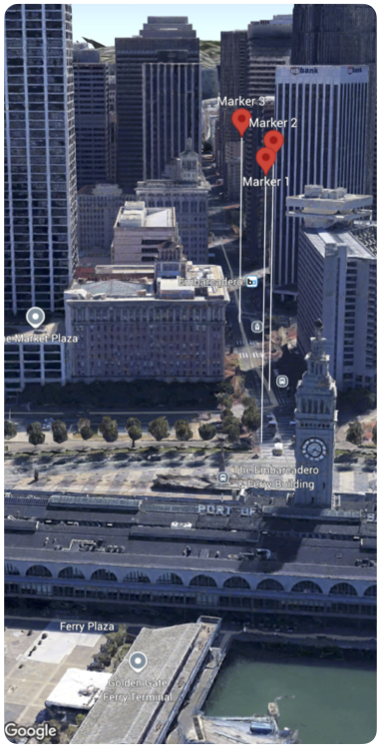
يوضّح نموذج الرمز البرمجي التالي كيفية ضبط collisionBehavior لبنية Marker لتحديد طريقة تصرّف العلامة عند تصادمها مع علامة أخرى أو تصادمها مع تصنيف الخريطة.
تاريخ التعديل الأخير: 2025-08-31 (حسب التوقيت العالمي المتفَّق عليه)
[null,null,["تاريخ التعديل الأخير: 2025-08-31 (حسب التوقيت العالمي المتفَّق عليه)"],[],[],null,["Select platform: [Android](/maps/documentation/maps-3d/android-sdk/configure-marker-collision-behavior \"View this page for the Android platform docs.\") [iOS](/maps/documentation/maps-3d/ios-sdk/configure-marker-collision-behavior \"View this page for the iOS platform docs.\") [JavaScript](/maps/documentation/javascript/3d/marker-collision \"View this page for the JavaScript platform docs.\")\n\n\u003cbr /\u003e\n\n| This product or feature is Experimental (pre-GA). Pre-GA products and features might have limited support, and changes to pre-GA products and features might not be compatible with other pre-GA versions. Pre-GA Offerings are covered by the [Google\n| Maps Platform Service Specific Terms](https://cloud.google.com/maps-platform/terms/maps-service-terms). For more information, see the [launch stage descriptions](/maps/launch-stages).\n\n\nYou can customize the collision behavior of markers that you add to a 3D map.\n\nThe following code sample demonstrates how configure the [`collisionBehavior` of the `Marker` struct](/maps/documentation/maps-3d/ios-sdk/reference/Structs/Marker#collisionbehavior) to specify how a marker should behave when it collides with anothermarker or map label. \n\nSwift\n\n```\nMap(camera: $camera, mode: .hybrid) {\n Marker(\n position: .init(\n latitude: 37.794724,\n longitude: -122.39442,\n altitude: 100.0),\n altitudeMode: .relativeToMesh,\n collisionBehavior: .optionalAndHidesLowerPriority,\n extruded: true,\n label: \"Marker 1\"\n )\n \n Marker(\n position: .init(\n latitude: 37.7943220,\n longitude: -122.395073,\n altitude: 100.0),\n altitudeMode: .relativeToMesh,\n collisionBehavior: .required,\n extruded: true,\n label: \"Marker 2\"\n )\n \n Marker(\n position: .init(\n latitude: 37.7934108,\n longitude: -122.396144,\n altitude: 100.0),\n altitudeMode: .relativeToMesh,\n collisionBehavior: .requiredAndHidesOptional,\n extruded: true,\n label: \"Marker 3\"\n )\n}\n \n```"]]