ফটোরিয়ালিস্টিক 3D টাইলস ওভারভিউ
সেভ করা পৃষ্ঠা গুছিয়ে রাখতে 'সংগ্রহ' ব্যবহার করুন
আপনার পছন্দ অনুযায়ী কন্টেন্ট সেভ করুন ও সঠিক বিভাগে রাখুন।
ইউরোপিয়ান ইকোনমিক এরিয়া (EEA) ডেভেলপার
ফটোরিয়ালিস্টিক 3D টাইলস হল মানচিত্রের টাইলস যা OGC 3D টাইলস ফর্ম্যাটে Google এর 3D জিওডাটা ধারণ করে। আপনি আপনার নিজস্ব 3D টাইলস রেন্ডারারের সাথে Google এর 3D মানচিত্র রেন্ডার করতে পারেন, অথবা আপনি 3D ভূ-স্থানিক ভিজ্যুয়ালাইজেশনের জন্য একটি ওপেন সোর্স লাইব্রেরি ব্যবহার করতে পারেন৷
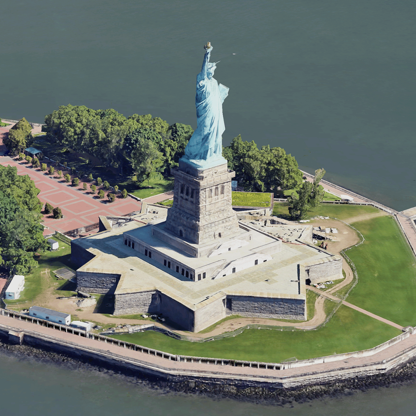
কেন 3D টাইলস ব্যবহার করবেন?
পরবর্তী প্রজন্মের ভিজ্যুয়ালাইজেশন ব্যবহারের ক্ষেত্রে Google 3D টাইলস অফার করে। আপনি অত্যাশ্চর্য 3D দৃষ্টিকোণ দৃশ্য তৈরি করতে 3D টাইলস ব্যবহার করতে পারেন, ঠিক যেমন আপনি Google আর্থের সাথে পারেন৷ এই দৃশ্যগুলি আপনার ব্যবহারকারীদের ভৌগলিক প্রেক্ষাপটকে আরও ভালভাবে বুঝতে সাহায্য করে, তারা কীভাবে নেভিগেট করে তা উন্নত করতে এবং তারা গল্প বলার জন্য একটি জায়গা দেখাতে পারে৷ আপনার পছন্দের একটি রেন্ডারার ব্যবহার করে, আপনি একটি দৃশ্যের মাধ্যমে আপনার ক্যামেরাটিকে বিভিন্ন কোণ থেকে দেখতে মসৃণভাবে চালনা করতে পারেন৷
কভারেজ এলাকা
মানচিত্র টাইলস API-এর কভারেজ পর্যালোচনা করুন। Google নিয়মিত আপডেট করে এবং ছবি যোগ করে।
3D সমাধান
Google মানচিত্র প্ল্যাটফর্ম আর্কিটেকচার সেন্টারে 3D সমাধানগুলির উদাহরণ রয়েছে যা আপনি আপনার অ্যাপের সাথে শুরু করতে পরীক্ষা করতে পারেন:
3D এরিয়া এক্সপ্লোরার : আপনাকে আশেপাশের এলাকা এবং এলাকাগুলিকে কার্যত এবং 3D তে উচ্চ মাত্রার ভিজ্যুয়াল বিশদ সহ অন্বেষণ করতে দেয়৷
3D স্টোরিটেলিং : গল্প বলার এবং ম্যাপিংকে সেতু করে, ফটোরিয়ালিস্টিক 3D টাইলস ব্যবহার করে নিমগ্ন এবং ইন্টারেক্টিভ বর্ণনা তৈরি করতে নির্মাতাদের সক্ষম করে।
অন্য কিছু উল্লেখ না করা থাকলে, এই পৃষ্ঠার কন্টেন্ট Creative Commons Attribution 4.0 License-এর অধীনে এবং কোডের নমুনাগুলি Apache 2.0 License-এর অধীনে লাইসেন্স প্রাপ্ত। আরও জানতে, Google Developers সাইট নীতি দেখুন। Java হল Oracle এবং/অথবা তার অ্যাফিলিয়েট সংস্থার রেজিস্টার্ড ট্রেডমার্ক।
2025-08-29 UTC-তে শেষবার আপডেট করা হয়েছে।
[null,null,["2025-08-29 UTC-তে শেষবার আপডেট করা হয়েছে।"],[[["\u003cp\u003ePhotorealistic 3D Tiles are map tiles containing Google's 3D geodata in the OGC 3D Tiles format, allowing rendering with your own or open source 3D Tiles renderers.\u003c/p\u003e\n"],["\u003cp\u003e3D Tiles empowers next-generation visualization, enabling stunning 3D perspective views for enhanced geographic context, navigation, and storytelling.\u003c/p\u003e\n"],["\u003cp\u003eGoogle's 3D Tiles offer coverage detailed in the Map Tiles API documentation, with regular updates and imagery additions.\u003c/p\u003e\n"],["\u003cp\u003eExplore 3D solutions like the 3D Area Explorer for detailed virtual exploration and 3D Storytelling for immersive narratives using Photorealistic 3D Tiles on the Google Maps Platform Architecture Center.\u003c/p\u003e\n"]]],[],null,["# Photorealistic 3D Tiles overview\n\n**European Economic Area (EEA) developers** If your billing address is in the European Economic Area, effective on 8 July 2025, the [Google\n| Maps Platform EEA Terms of Service](https://cloud.google.com/terms/maps-platform/eea) will apply to your use of the Services. [Learn more](/maps/comms/eea/faq). In addition, certain content from the Map Tiles API will no longer be returned. [Learn more](/maps/comms/eea/map-tiles).\n\n:statue_of_liberty:Photorealistic 3D Tiles are map tiles that contain Google's 3D\ngeodata in the\n[OGC 3D Tiles format](https://www.ogc.org/standards/3DTiles).\nYou can render Google's 3D maps with your own 3D Tiles renderer, or you can use\nan open source library for 3D geospatial visualization.\n\nWhy use 3D Tiles?\n-----------------\n\nGoogle offers 3D Tiles for next-generation visualization use cases. You can use\n3D Tiles to build stunning 3D perspective views, just as you can with Google\nEarth. These views help your users better understand geographic context, improve\nhow they navigate, and they can showcase a place for storytelling. Using a\nrenderer of your choice, you can also smoothly maneuver your camera through a\nscene to view it from different angles.\n\nCoverage areas\n--------------\n\nReview the Map Tiles API's\n[coverage](/maps/coverage#countryregion-coverage). Google regularly updates and\nadds imagery.\n\n3D solutions\n------------\n\nThe [Google Maps Platform Architecture Center](/maps/architecture)\ncontains examples of 3D solutions that you can examine to get started with your\napp:\n\n- [3D Area Explorer](/maps/architecture/3d-area-explorer):\n Lets you explore neighborhoods and areas virtually and in 3D with a\n high degree of visual detail.\n\n- [3D Storytelling](/maps/architecture/3d-storytelling):\n Bridges storytelling and mapping, enabling creators to craft immersive and\n interactive narratives using Photorealistic 3D Tiles."]]