- Dostępność zbioru danych
- 2012-01-01T00:00:00Z–2012-01-01T00:00:00Z
- Dostawca zbioru danych
- AHN
- Tagi
Opis
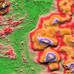
AHN DEM to model terenu o rozdzielczości 0,5 m obejmujący Holandię. Została wygenerowana na podstawie danych LIDAR zebranych wiosną w latach 2007–2012.
Zawiera próbki na poziomie gruntu, z których usunięto wszystkie inne obiekty znajdujące się nad ziemią (np. budynki, mosty, drzewa itp.). Ta wersja jest interpolowana. Obszary, z których usunięto obiekty, są wypełnione interpolowanymi wartościami. Chmura punktów została przekształcona w siatkę o rozmiarze 0,5 m przy użyciu metody ważenia kwadratową odwrotnością odległości.
Pasma
Pasma
Rozmiar piksela: 0,5 m (wszystkie pasma)
| Nazwa | Jednostki | Rozmiar piksela | Opis |
|---|---|---|---|
elevation |
m | 0,5 metra | Wysokość |
Warunki korzystania z usługi
Warunki korzystania z usługi
Zbiory danych AHN są dostępne jako otwarte dane. Oznacza to, że każdy może korzystać z tych danych bezpłatnie i bez ograniczeń. Więcej informacji znajdziesz na stronie Otwarte dane. Pliki do pobrania są dostępne na warunkach licencji CC-0.
Odkrywaj za pomocą Earth Engine
Edytor kodu (JavaScript)
var dataset = ee.Image('AHN/AHN2_05M_INT');
var elevation = dataset.select('elevation');
var elevationVis = {
  min: -5.0,
  max: 30.0,
};
Map.setCenter(5.76583, 51.855276, 16);
Map.addLayer(elevation, elevationVis, 'Elevation');
import ee
import geemap.core as geemap
Colab (Python)
dataset = ee.Image('AHN/AHN2_05M_INT')
elevation = dataset.select('elevation')
elevation_vis = {'min': -5.0, 'max': 30.0}

m = geemap.Map()
m.set_center(5.76583, 51.855276, 16)
m.add_layer(elevation, elevation_vis, 'Elevation')
m