- Dostępność zbioru danych
- 2014-01-01T00:00:00Z–2019-01-01T00:00:00Z
- Dostawca zbioru danych
- AHN
- Tagi
Opis
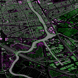
Actueel Hoogtebestand Nederland (AHN) to zbiór danych zawierający szczegółowe i precyzyjne dane o wysokości dla całej Holandii. Dane o wysokości zostały zebrane z helikopterów i samolotów za pomocą technologii laserowej z dokładnością pionową wynoszącą 5 cm.
Zbiór danych AHN3 zawiera zmienne AHN 0,5 m DSM i DTM w Holandii. Dane obejmują okres od 2014 r. do 2019 r.
Cyfrowy model terenu (DTM) przedstawia wysokość gruntu, a cyfrowy model powierzchni (DSM) – wysokość najwyższych powierzchni w danym punkcie.
Pasma
Pasma
Rozmiar piksela: 0,5 m (wszystkie pasma)
| Nazwa | Jednostki | Rozmiar piksela | Opis |
|---|---|---|---|
dtm |
m | 0,5 metra | Wysokość nad poziomem morza |
dsm |
m | 0,5 metra | Wysokość najwyższych powierzchni w danym punkcie |
Warunki korzystania z usługi
Warunki korzystania z usługi
Zbiory danych AHN są dostępne jako otwarte dane. Oznacza to, że każdy może korzystać z tych danych bezpłatnie i bez ograniczeń. Więcej informacji znajdziesz na stronie Otwarte dane. Pliki do pobrania są dostępne na warunkach licencji CC-0.
Odkrywaj za pomocą Earth Engine
Edytor kodu (JavaScript)
var dataset = ee.ImageCollection('AHN/AHN3');
var elevation = dataset.select('dsm');
var elevationVis = {
  min: -5.0,
  max: 30.0,
};
Map.setCenter(5.76583, 51.855276, 16);
Map.addLayer(elevation, elevationVis, 'AHN3 dsm');