- Dostępność zbioru danych
- 2020-01-01T00:00:00Z–2021-01-01T00:00:00Z
- Dostawca zbioru danych
- BNETD-CIGN
- Cykl
- 1 rok
- Tagi
Opis
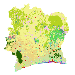
Mapa pokrycia terenu Wybrzeża Kości Słoniowej BNETD 2020 została opracowana przez rząd Wybrzeża Kości Słoniowej za pośrednictwem instytucji krajowej, Centrum Informacji Geograficznej i Cyfrowej z Krajowego Biura Studiów i Rozwoju (BNETD-CIGN), przy wsparciu technicznym i finansowym Unii Europejskiej. Metodologia użyta do utworzenia mapy była przejrzysta, oparta na współpracy i zgodna z międzynarodowymi standardami.
Aby opracować tę mapę, przetworzono w Google Earth Engine mozaikę zdjęć satelitarnych (Sentinel 2) z 2020 r. i uzupełniono ją danymi zebranymi w terenie, aby wytrenować algorytm klasyfikacji nadzorowanej (Random Forest). W całym kraju przeprowadzono 2 kampanie terenowe: od 10 listopada do 9 grudnia 2022 r. i od 26 stycznia do 13 lutego 2023 r. W tych misjach uczestniczyły 33 osoby z różnych organizacji partnerskich, ponieważ metody zbierania danych i definicje niektórych klas użytkowania gruntów przyjęte przez zainteresowane strony mogą się czasami różnić.
W ramach procesu należytej staranności wymaganego przez rozporządzenie UEDR dane geolokalizacyjne działek, na których produkowane są produkty objęte tym rozporządzeniem, można nałożyć na dane dotyczące pokrywy leśnej z 2020 roku, aby ocenić ryzyko, że działka znajduje się na obszarze, który był zalesiony przed datą graniczną 2020 roku. W tym celu potrzebne są dane dotyczące pokrywy leśnej zgodne z definicją lasów FAO i datą graniczną 2020 r. Mapa pokrycia terenu z 2020 r. w przypadku Wybrzeża Kości Słoniowej spełnia te potrzeby. Klasy na mapie pokrycia terenu można połączyć, aby utworzyć mapę lasów i obszarów nieleśnych zgodną z definicją lasów FAO.
Platforma umożliwiająca dostęp do danych o pokryciu terenu z 2020 r., metadanych i metodologii została opracowana przy użyciu rozwiązań ESRI z Africa GeoPortal do analizy i wizualizacji danych:
Adres to: https://bit.ly/carte-ci-2020
Dokumentacja:
Pasma
Rozmiar piksela
10 metrów
Pasma
| Nazwa | Minimum | Maks. | Rozmiar piksela | Opis |
|---|---|---|---|---|
classification |
1 | 23 | metry | Klasa pokrycia terenu |
Tabela klasyfikacji
| Wartość | Kolor | Opis |
|---|---|---|
| 1 | #276300 | Gęsty las (Forêt dense) |
| 2 | #59D757 | Jasny las (Forêt claire) |
| 3 | #569D6E | Forest gallery (Forêt galerie) |
| 4 | #79CFAD | Las wtórny/zdegradowany (Forêt secondaire/forêt dégradée) |
| 5 | #34734C | Mangrove |
| 6 | #B4FFAD | Plantacja leśna/ponowne zalesienie (Plantation forestière/Reboisement) |
| 7 | #6EFA9A | Swamp forest/Forest on hydromorphic soil (Forêt marécageuse/Forêt sur sol hydromorphe) |
| 8 | #D68589 | Plantacja kawy (Plantation de Café) |
| 9 | #EBD37F | Cocoa Plantation (Plantation de Cacao) |
| 10 | #D0E09D | Plantacja kauczukowca (Plantation d'Hévéa) |
| 11 | #E8BEFF | Plantacja palm olejowych (Plantation de Palmier à huile) |
| 12 | #E751FE | Coconut Plantation (Plantation de Coco) |
| 13 | #F3BFF2 | Plantacja nerkowców (Plantation d'Anacarde) |
| 14 | #9DFD00 | Plantacja owoców / Sadownictwo (Plantation fruitière / Arboricultures) |
| 15 | #F2F38D | Rozwój rolnictwa/inne uprawy/sady/ugory (Aménagement agricole/Autres cultures/Vergers/Jachères) |
| 16 | #B6D322 | Sawanna drzewiasta (Savane arborée) |
| 17 | #E2FE5F | Formacje krzewów/ zarośla (Formations arbustives/ Fourrés) |
| 18 | #F9FDCC | Formacje zielne (Formations herbacées) |
| 19 | #4A70C0 | Akwen, szlaki wodne (Plan d'eau, Cours et voies deau) |
| 20 | #BEFFE8 | Obszar podmokły (Zone marécageuse) |
| 21 | #D20A02 | Human habitat, Infrastructure (Habitat humain, Infrastructures) |
| 22 | #DBECEF | Wychodnia skalna (Affleurement rocheux) |
| 23 | #DCDCDC | Bare ground (Sol nu) |
Warunki korzystania z usługi
Warunki usługi
Cytowanie
BNETD Land Cover Map 2020.
Odkrywaj za pomocą Earth Engine
Edytor kodu (JavaScript)
var dataset = ee.Image('BNETD/land_cover/v1/2020').select('classification');

Map.setCenter(-5.4400, 7.5500, 7);

Map.addLayer(dataset, {}, "Cote d'Ivoire Land Cover Map 2020");