-
Mapa pokrycia terenu BNETD 2020 w Wybrzeżu Kości Słoniowej
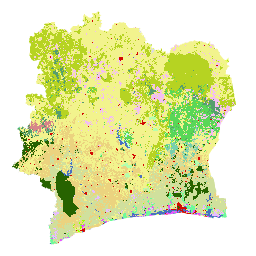
Mapa pokrycia terenu Wybrzeża Kości Słoniowej BNETD 2020 została opracowana przez rząd Wybrzeża Kości Słoniowej za pośrednictwem instytucji krajowej, Centrum Informacji Geograficznej i Cyfrowej z Krajowego Biura Studiów Technicznych i Rozwoju (BNETD-CIGN), przy wsparciu technicznym i finansowym Unii Europejskiej. Metodologia … classification deforestation forest landcover landuse-landcover -
Globalna klasyfikacja lasów w 2020 r. na potrzeby szacunków biomasy nadziemnej IPCC na poziomie 1, wersja 1
Ten zbiór danych zawiera klasy lasów na całym świecie wyodrębnione według stanu/kondycji w 2020 r. w rozdzielczości około 30 m. Dane te umożliwiają generowanie szacunków poziomu 1 dotyczących gęstości suchej biomasy drzewnej nad ziemią (AGBD) w lasach naturalnych w ramach ulepszeń z 2019 r. do wytycznych IPCC z 2006 r. dotyczących krajowych inwentaryzacji gazów cieplarnianych. aboveground biomass carbon classification forest forest-biomass -
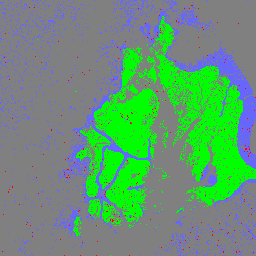
Globalna 3-klasowa mapa PALSAR-2/PALSAR Forest/Non-Forest

Nowszą wersję tego zbioru danych z 4 klasami na lata 2017–2020 znajdziesz w JAXA/ALOS/PALSAR/YEARLY/FNF4. Globalna mapa lasów i obszarów nieleśnych (FNF) jest generowana przez klasyfikację obrazu SAR (współczynnika rozpraszania wstecznego) w globalnej mozaice SAR PALSAR-2/PALSAR o rozdzielczości 25 m, tak aby piksele o silnym i słabym rozpraszaniu wstecznym… alos alos2 klasyfikacja eroc las biomasa-lasu -
Globalna 4-klasowa mapa lasów i terenów niezalesionych PALSAR-2/PALSAR

Globalna mapa lasów i obszarów nieleśnych (FNF) jest generowana przez klasyfikację obrazu SAR (współczynnika rozpraszania wstecznego) w globalnej mozaice SAR PALSAR-2/PALSAR o rozdzielczości 25 m, tak aby piksele o silnym i słabym rozpraszaniu wstecznym były przypisywane odpowiednio jako „las” i „obszar nieleśny”. „Las” jest tu zdefiniowany jako las naturalny z … alos alos2 klasyfikacja eroc las biomasa-lasu
Datasets tagged classification in Earth Engine
[null,null,[],[],[]]