- Phạm vi cung cấp tập dữ liệu
- 2020-01-01T00:00:00Z–2021-01-01T00:00:00Z
- Nhà sản xuất tập dữ liệu
- BNETD-CIGN
- Tần suất
- 1 năm
- Thẻ
Mô tả
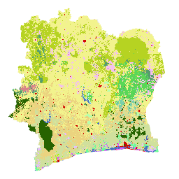
Bản đồ lớp phủ mặt đất năm 2020 của Bờ Biển Ngà do Chính phủ Bờ Biển Ngà sản xuất thông qua một tổ chức quốc gia, Trung tâm Thông tin Địa lý và Kỹ thuật số thuộc Văn phòng Nghiên cứu và Phát triển Quốc gia (BNETD-CIGN), với sự hỗ trợ kỹ thuật và tài chính của Liên minh Châu Âu. Phương pháp được dùng để tạo bản đồ là minh bạch, có sự tham gia và tuân thủ các tiêu chuẩn quốc tế.
Để phát triển bản đồ này, một tổ hợp hình ảnh vệ tinh (Sentinel 2) từ năm 2020 đã được xử lý thông qua Google Earth Engine và bổ sung dữ liệu thu thập được tại hiện trường, để huấn luyện một thuật toán phân loại có giám sát (Rừng ngẫu nhiên). Hai chiến dịch thực địa đã được tiến hành từ ngày 10 tháng 11 đến ngày 9 tháng 12 năm 2022 và từ ngày 26 tháng 1 đến ngày 13 tháng 2 năm 2023 trên toàn quốc. Các nhiệm vụ này có sự tham gia của 33 người thuộc nhiều tổ chức đối tác vì các phương pháp thu thập dữ liệu và định nghĩa về một số loại hình sử dụng đất mà các bên liên quan áp dụng đôi khi có thể khác nhau.
Trong quy trình thẩm định theo EUDR, dữ liệu vị trí địa lý của các lô đất sản xuất sản phẩm liên quan đến EUDR có thể được chồng lên dữ liệu về độ che phủ rừng năm 2020 để đánh giá rủi ro rằng lô đất đó nằm ở khu vực có rừng trước ngày cắt là năm 2020. Để làm được việc này, bạn cần có dữ liệu về độ che phủ rừng phù hợp với định nghĩa của FAO về rừng và ngày cắt là năm 2020. Bản đồ lớp phủ mặt đất năm 2020 của Bờ Biển Ngà đáp ứng những nhu cầu này. Thật vậy, các lớp trong bản đồ lớp phủ đất có thể được kết hợp để tạo ra một bản đồ rừng/không phải rừng phù hợp với định nghĩa của FAO về rừng.
Một nền tảng để truy cập vào dữ liệu, siêu dữ liệu và phương pháp lớp phủ mặt đất năm 2020 đã được phát triển bằng các giải pháp của ESRI, từ Africa GeoPortal, để phân tích và trực quan hoá dữ liệu:
Địa chỉ là: https://bit.ly/carte-ci-2020
Tài liệu:
Băng tần
Băng tần
Kích thước pixel: 10 mét (tất cả các dải tần)
| Tên | Tối thiểu | Tối đa | Kích thước pixel | Mô tả |
|---|---|---|---|---|
classification |
1 | 23 | 10 mét | Lớp phủ mặt đất |
Bảng phân loại
| Giá trị | Màu | Mô tả |
|---|---|---|
| 1 | #276300 | Rừng rậm (Forêt dense) |
| 2 | #59D757 | Rừng thưa (Forêt claire) |
| 3 | #569D6E | Phòng trưng bày Forest (Forêt galerie) |
| 4 | #79CFAD | Rừng thứ sinh/rừng suy thoái (Forêt secondaire/forêt dégradée) |
| 5 | #34734C | Mangrove |
| 6 | #B4FFAD | Trồng rừng/Tái trồng rừng (Plantation forestière/Reboisement) |
| 7 | #6EFA9A | Rừng đầm lầy/Rừng trên đất thuỷ sinh (Forêt marécageuse/Forêt sur sol hydromorphe) |
| 8 | #D68589 | Đồn điền cà phê (Plantation de Café) |
| 9 | #EBD37F | Cocoa Plantation (Plantation de Cacao) |
| 10 | #D0E09D | Đồn điền cao su (Plantation d'Hévéa) |
| 11 | #E8BEFF | Đồn điền cọ dầu (Plantation de Palmier à huile) |
| 12 | #E751FE | Coconut Plantation (Plantation de Coco) |
| 13 | #F3BFF2 | Đồn điền hạt điều (Plantation d'Anacarde) |
| 14 | #9DFD00 | Đồn điền trồng cây ăn quả / Trồng cây (Plantation fruitière / Arboricultures) |
| 15 | #F2F38D | Phát triển nông nghiệp/Các loại cây trồng khác/Vườn cây ăn quả/Đất bỏ hoang (Aménagement agricole/Autres cultures/Vergers/Jachères) |
| 16 | #B6D322 | Savannah có cây (Savane arborée) |
| 17 | #E2FE5F | Cụm cây bụi/ Bụi cây (Cụm cây bụi/ Bụi cây) |
| 18 | #F9FDCC | Thảm thực vật thân thảo (Formations herbacées) |
| 19 | #4A70C0 | Vùng nước, Sân golf và tuyến đường thuỷ (Plan d'eau, Cours et voies deau) |
| 20 | #BEFFE8 | Vùng đầm lầy (Zone marécageuse) |
| 21 | #D20A02 | Môi trường sống của con người, Cơ sở hạ tầng (Habitat humain, Infrastructures) |
| 22 | #DBECEF | Rocky outcrop (Affleurement rocheux) |
| 23 | #DCDCDC | Đất trống (Sol nu) |
Điều khoản sử dụng
Điều khoản sử dụng
Trích dẫn
Bản đồ lớp phủ mặt đất BNETD năm 2020.
Khám phá bằng Earth Engine
Trình soạn thảo mã (JavaScript)
var dataset = ee.Image('BNETD/land_cover/v1/2020').select('classification');

Map.setCenter(-5.4400, 7.5500, 7);

Map.addLayer(dataset, {}, "Cote d'Ivoire Land Cover Map 2020");