- در دسترس بودن مجموعه دادهها
- 2019-01-01T01:00:00Z–2020-01-01T01:00:00Z
- تولیدکننده مجموعه داده
- سیستم اطلاعات ملی جنگل
- برچسبها
توضیحات
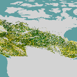
مجموعه دادههای جنگلهای اولیه کانادا، یک نقشه ماهوارهای از سن جنگلها برای سال ۲۰۱۹ در سراسر مناطق جنگلی کانادا با وضوح مکانی ۳۰ متر است. دادههای سنجش از دور لندست (آشفتگیها، ترکیبات بازتاب سطحی، ساختار جنگل) و MODIS (تولید ناخالص اولیه) برای تعیین سن استفاده میشوند.
سن جنگل را میتوان در جایی که اختلال مستقیماً قابل شناسایی است (رویکرد اختلال) یا با استفاده از اطلاعات طیفی (رویکرد بازیابی) یا با استفاده از معادلات آلومتریک معکوس برای مدلسازی سن در جایی که هیچ مدرکی از اختلال وجود ندارد (رویکرد آلومتریک) تعیین کرد. رویکرد اختلال مبتنی بر دادههای ماهوارهای و تغییرات نقشهبرداری شده است و دقیقترین رویکرد است. رویکرد بازیابی همچنین به دادههای ماهوارهای به علاوه منطق مربوط به توالی جنگل متکی است، با دقتی که بیشتر از مدلسازی خالص است.
با توجه به عدم وجود اختلال گسترده اخیر در جنگلهای کانادا، رویکرد آلومتریک در بزرگترین منطقه (۸۶.۶٪) مورد نیاز است. با استفاده از اطلاعات مربوط به ارتفاعهای واقعی و مدلسازی رشد و عملکرد، سن درختان در مواردی که به روش دیگری امکانپذیر نیست، تخمین زده میشود. درختان در تمام سنین نقشهبرداری میشوند و درختانی که بیش از ۱۵۰ سال سن دارند در یک دسته "درخت مسن" قرار میگیرند.
باندها
باندها
اندازه پیکسل: 30 متر (همه باندها)
| نام | واحدها | اندازه پیکسل | توضیحات |
|---|---|---|---|
forest | ی | ۳۰ متر | سن جنگل |
شرایط استفاده
شرایط استفاده
نقشه سن جنگل که در اینجا برای اکوسیستمهای جنگلی کانادا شرح داده شده است، متنباز اعلام شده و توسط دولت کانادا پشتیبانی میشود. این مجموعه دادهها تحت مجوز CC-BY 4.0 منتشر شده است.
با موتور زمین کاوش کنید
ویرایشگر کد (جاوااسکریپت)
var dataset = ee.ImageCollection('CANADA/NFIS/NTEMS/CA_FOREST_AGE');

Map.setCenter(-107.94, 58.18, 3);
Map.addLayer(
    dataset,
    {palette: ['006600', '002200', 'fff700', 'ab7634', 'c4d0ff', 'ffffff']},
    'Canada Primary Forest Data');