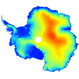
Ten zbiór danych to cyfrowy model terenu (DEM) pokrywy lodowej Antarktydy i szelfów lodowych na podstawie obserwacji zarejestrowanych przez radarowy wysokościomierz satelity CryoSat-2 w okresie od lipca 2010 r. do lipca 2016 r.
Model DEM jest tworzony na podstawie dopasowań przestrzenno-czasowych do pomiarów wysokości zgromadzonych w komórkach siatki o rozmiarach 1, 2 i 5 km. Jest on publikowany w rozdzielczości modalnej 1 km. Mediana i średnia kwadratowa różnica między modelem DEM a pomiarami wysokości wykonanymi za pomocą lotniczego altimetru laserowego podczas kampanii NASA Operation IceBridge wynoszą odpowiednio -0,30 m i 13,50 m.
Niepewność DEM rośnie na obszarach o dużym nachyleniu, zwłaszcza tam, gdzie pomiary wysokości zostały uzyskane w trybie niskiej rozdzielczości.Biorąc to pod uwagę, szacujemy, że średnia dokładność wynosi 9,5 m.
Pasma
Rozmiar piksela 1000 metrów
Pasma
Nazwa
Jednostki
Rozmiar piksela
Opis
elevation
m
metry
Wysokość pokrywy lodowej i szelfu lodowego Antarktydy.
data_composition
metry
Metoda przetwarzania danych o wysokości dla każdej komórki siatki.
slope
deg
metry
Nachylenie obliczone na podstawie gradientu wysokości.
z_smoothed
m
metry
Wygładzona wersja modelu wysokościowego z użyciem filtra medianowego.
z_uncertainty
m
metry
Pewność modelu wysokościowego wynikająca z RMS reszt wysokości w obserwowanych komórkach siatki i błędu wariancji krigingu w interpolowanych komórkach siatki.
Slater, T., Shepherd, A., McMillan, M., Muir, A., Gilbert, L.,
Hogg, A. E., Konrad, H. i Parrinello, T.: A new Digital Elevation
Model of Antarctica derived from CryoSat-2 altimetry, The Cryosphere,
doi:10.5194/tc-2017-223, 2018
Ten zbiór danych to cyfrowy model wysokościowy (DEM) pokrywy lodowej i szelfów lodowych Antarktydy na podstawie obserwacji zarejestrowanych przez radarowy wysokościomierz satelity CryoSat-2 w okresie od lipca 2010 r. do lipca 2016 r. Model DEM jest tworzony na podstawie dopasowań przestrzenno-czasowych do pomiarów wysokości zgromadzonych w siatce o rozmiarach 1, 2 i 5 km…
[null,null,[],[[["\u003cp\u003eThis dataset provides a 1 km resolution digital elevation model (DEM) of the Antarctic ice sheet and ice shelves.\u003c/p\u003e\n"],["\u003cp\u003eThe DEM is derived from CryoSat-2 satellite radar altimetry data collected between July 2010 and July 2016.\u003c/p\u003e\n"],["\u003cp\u003eIt includes elevation, data composition, slope, a smoothed elevation model, and elevation uncertainty bands.\u003c/p\u003e\n"],["\u003cp\u003eThe DEM has an average accuracy of 9.5m and was validated against NASA Operation IceBridge airborne laser altimeter measurements.\u003c/p\u003e\n"],["\u003cp\u003eThe dataset is provided by CPOM and has specific terms of use.\u003c/p\u003e\n"]]],["The dataset provides a digital elevation model (DEM) of the Antarctic ice sheet and shelves, derived from CryoSat-2 satellite radar altimeter observations between July 2010 and July 2016. Elevation measurements were fitted within 1, 2, and 5 km grid cells, with a 1 km modal resolution. The data includes elevation, data composition, slope, a smoothed elevation version, and elevation uncertainty. Users can access the dataset through Earth Engine using a provided code snippet. The average accuracy is estimated to be 9.5m.\n"],null,["# CryoSat-2 Antarctica 1km DEM\n\nDataset Availability\n: 2010-07-01T00:00:00Z--2016-07-01T00:00:00Z\n\nDataset Provider\n:\n\n\n [CPOM](http://www.cpom.ucl.ac.uk/csopr/icesheets2/dems.php?ais_subject=dem&user_type=normal)\n\nTags\n:\n [antarctica](/earth-engine/datasets/tags/antarctica) [dem](/earth-engine/datasets/tags/dem) [elevation](/earth-engine/datasets/tags/elevation) [elevation-topography](/earth-engine/datasets/tags/elevation-topography) [polar](/earth-engine/datasets/tags/polar) \n cpom \ncryosat-2 \n\n#### Description\n\nThis dataset is a digital elevation model (DEM) of the\nAntarctic ice sheet and ice shelves based on\nobservations recorded by the CryoSat-2 satellite\nradar altimeter between July 2010 and July 2016.\n\nThe DEM is formed from spatio-temporal fits to elevation\nmeasurements accumulated within 1, 2, and 5 km grid cells,\nand is posted at the modal resolution of 1 km. The median\nand root mean square difference between the DEM and 2.3\\*10^7^;\nairborne laser altimeter measurements acquired during\nNASA Operation IceBridge campaigns are -0.30 and 13.50 m,\nrespectively.\n\nThe DEM uncertainty rises in regions of high slope,\nespecially where elevation measurements were acquired in\nlow-resolution mode; taking this into account, we estimate\nthe average accuracy to be 9.5 m.\n\n### Bands\n\n\n**Pixel Size**\n\n1000 meters\n\n**Bands**\n\n| Name | Units | Pixel Size | Description |\n|--------------------|-------|------------|--------------------------------------------------------------------------------------------------------------------------------------------------------|\n| `elevation` | m | meters | Antarctic ice sheet and ice shelf elevation. |\n| `data_composition` | | meters | Data processing method of elevation per grid cell. |\n| `slope` | deg | meters | Slope derived from elevation gradient. |\n| `z_smoothed` | m | meters | Smoothed version of elevation model using a median filter. |\n| `z_uncertainty` | m | meters | Certainty of elevation model derived from RMS of elevation residuals in observed grid cells and the kriging variance error in interpolated grid cells. |\n\n**data_composition Class Table**\n\n| Value | Color | Description |\n|-------|---------|--------------------|\n| 0 | #000000 | interpolated |\n| 1 | #cbcbcb | 1 km fit |\n| 2 | #377eb7 | resampled 2 km fit |\n| 3 | #e2191b | resampled 5 km fit |\n\n### Terms of Use\n\n**Terms of Use**\n\n[proprietary](/earth-engine/datasets/catalog/Use%20a%20custom%20URL%20for%20the%20non-standard%20license)\n\n### Citations\n\nCitations:\n\n- Slater, T., Shepherd, A., McMillan, M., Muir, A., Gilbert, L.,\n Hogg, A. E., Konrad, H. and Parrinello, T.: A new Digital Elevation\n Model of Antarctica derived from CryoSat-2 altimetry, The Cryosphere,\n [doi:10.5194/tc-2017-223](https://doi.org/10.5194/tc-2017-223), 2018\n\n### DOIs\n\n- \u003chttps://doi.org/10.5194/tc-2017-223\u003e\n\n### Explore with Earth Engine\n\n| **Important:** Earth Engine is a platform for petabyte-scale scientific analysis and visualization of geospatial datasets, both for public benefit and for business and government users. Earth Engine is free to use for research, education, and nonprofit use. To get started, please [register for Earth Engine access.](https://console.cloud.google.com/earth-engine)\n\n### Code Editor (JavaScript)\n\n```javascript\nvar dataset = ee.Image('CPOM/CryoSat2/ANTARCTICA_DEM');\n\nvar visualization = {\n bands: ['elevation'],\n min: 0.0,\n max: 4000.0,\n palette: ['001fff', '00ffff', 'fbff00', 'ff0000']\n};\n\nMap.setCenter(17.0, -76.0, 3);\n\nMap.addLayer(dataset, visualization, 'Elevation');\n```\n[Open in Code Editor](https://code.earthengine.google.com/?scriptPath=Examples:Datasets/CPOM/CPOM_CryoSat2_ANTARCTICA_DEM) \n[CryoSat-2 Antarctica 1km DEM](/earth-engine/datasets/catalog/CPOM_CryoSat2_ANTARCTICA_DEM) \nThis dataset is a digital elevation model (DEM) of the Antarctic ice sheet and ice shelves based on observations recorded by the CryoSat-2 satellite radar altimeter between July 2010 and July 2016. The DEM is formed from spatio-temporal fits to elevation measurements accumulated within 1, 2, and 5 km grid ... \nCPOM/CryoSat2/ANTARCTICA_DEM, antarctica,dem,elevation,elevation-topography,polar \n2010-07-01T00:00:00Z/2016-07-01T00:00:00Z \n-88 -180 -60 180 \nGoogle Earth Engine \nhttps://developers.google.com/earth-engine/datasets\n\n- [https://doi.org/10.5194/tc-2017-223](https://doi.org/http://www.cpom.ucl.ac.uk/csopr/icesheets2/dems.php?ais_subject=dem&user_type=normal)\n- [https://doi.org/10.5194/tc-2017-223](https://doi.org/https://developers.google.com/earth-engine/datasets/catalog/CPOM_CryoSat2_ANTARCTICA_DEM)"]]