-
CryoSat-2 Antarctica 1km DEM
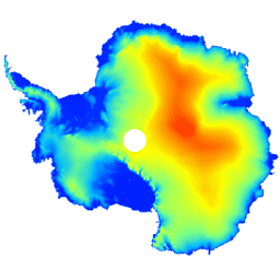
Ten zbiór danych to numeryczny model terenu (DEM) pokrywy lodowej Antarktydy i szelfów lodowych na podstawie obserwacji zarejestrowanych przez radarowy wysokościomierz satelity CryoSat-2 w okresie od lipca 2010 r. do lipca 2016 r. Model DEM jest tworzony na podstawie dopasowań przestrzenno-czasowych do pomiarów wysokości zgromadzonych w ciągu 1, … antarctica dem elevation elevation-topography polar -
Landsat Image Mosaic of Antarctica (LIMA) - Processed Landsat Scenes (16 bit)

Mozaika obrazów Antarktydy z satelity Landsat (LIMA) to spójna i praktycznie bezchmurna mozaika utworzona z przetworzonych zdjęć z satelity Landsat 7 ETM+. Przetworzone sceny Landsat (16-bitowe) to sceny NLAPS poziomu 1Gt przekonwertowane na 16-bitowe, przetworzone z korekcją kąta padania promieni słonecznych i przekonwertowane na wartości odbicia (Bindschadler … antarktyda lód landsat lima mozaika zdjęcia-satelitarne -
Landsat Image Mosaic of Antarctica (LIMA) - Processed Landsat Scenes (16 bit) Metadata

Mozaika obrazów Antarktydy z satelity Landsat (LIMA) to spójna i praktycznie bezchmurna mozaika utworzona z przetworzonych zdjęć z satelity Landsat 7 ETM+. Przetworzone sceny Landsat (16-bitowe) to sceny NLAPS poziomu 1Gt przekonwertowane na 16-bitowe, przetworzone z korekcją kąta padania promieni słonecznych i przekonwertowane na wartości odbicia (Bindschadler … antarktyda lód landsat lima mozaika zdjęcia-satelitarne -
Landsat Image Mosaic of Antarctica (LIMA) 16-Bit Pan-Sharpened Mosaic

Mozaika obrazów Antarktydy z satelity Landsat (LIMA) to spójna i praktycznie bezchmurna mozaika utworzona z przetworzonych zdjęć z satelity Landsat 7 ETM+. Ten zbiór danych LIMA to 16-bitowy zbiór danych Intermediate LIMA. Mozaika składa się z wyostrzonych obrazów znormalizowanego odbicia powierzchniowego (pasm 1, 2, 3 i … antarktyda lód landsat lima mozaika zdjęcia-satelitarne
Datasets tagged antarctica in Earth Engine
[null,null,[],[],[]]