- זמינות קבוצת הנתונים
- 2006-01-24T00:00:00Z–2011-05-13T00:00:00Z
- מפיק מערך הנתונים
- Conservation Science Partners
- תגים
תיאור
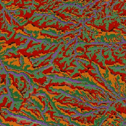
קבוצת הנתונים ALOS Landform מספקת סיווגים של צורות נוף שנוצרו משילוב של קבוצות הנתונים Continuous Heat-Insolation Load Index (מדד עומס רציף של קרינת שמש) ו-multi-scale Topographic Position Index (מדד מיקום טופוגרפי רב-קנה מידה, mTPI). הוא מבוסס על USGS's 10m NED DEM (זמין ב-EE כ-USGS/NED).
מערכי הנתונים, צורות הנוף והפיזיוגרפיה של Conservation Science Partners (שותפי מדעי השימור, CSP) Ecologically Relevant Geomorphology (גאומורפולוגיה רלוונטית מבחינה אקולוגית, ERGo) מכילים נתונים מפורטים ורב-קנה מידה על צורות נוף ודפוסים פיזיוגרפיים (שנקראים גם פני שטח). אף על פי שיש הרבה שימושים פוטנציאליים לנתונים האלה, המטרה המקורית שלהם הייתה לפתח סיווג ומפה רלוונטיים מבחינה אקולוגית של צורות נוף וסיווגים פיזיוגרפיים שמתאימים לתכנון הסתגלות לאקלים. מכיוון שיש אי ודאות רבה לגבי תנאי האקלים העתידיים, ועוד יותר אי ודאות לגבי תגובות אקולוגיות, מידע על מה שלא צפוי להשתנות מספק בסיס חזק למנהלים לבניית תוכניות חזקות להתאמה לאקלים. הכמות של התכונות האלה בנוף תלויה ברזולוציה, ולכן אנחנו מספקים את הרזולוציה הגבוהה ביותר שאפשר בהתחשב בהיקף ובמאפיינים של אינדקס נתון.
תחום תדרים
תחום תדרים
גודל הפיקסל: 10 מטרים (כל הפסים)
| שם | גודל הפיקסל | תיאור |
|---|---|---|
constant |
10 מטרים | סיווג צורות קרקע שנגזר מ-NED |
טבלת סיווג קבועה
| ערך | צבע | תיאור |
|---|---|---|
| 11 | #141414 | פסגה/רכס (חם) |
| 12 | #383838 | פסגה/רכס |
| 13 | #808080 | פסגה/רכס (קריר) |
| 14 | #ebeb8f | הרים/קו פרשת מים |
| 15 | #f7d311 | צוק |
| 21 | #aa0000 | שיפוע עליון (חם) |
| 22 | #d89382 | שיפוע עליון |
| 23 | #ddc9c9 | שיפוע עליון (קריר) |
| 24 | #dccdce | שיפוע עליון (שטוח) |
| 31 | #1c6330 | שיפוע נמוך יותר (חם) |
| 32 | #68aa63 | שיפוע נמוך יותר |
| 33 | #b5c98e | שיפוע מתון (קריר) |
| 34 | #e1f0e5 | שיפוע נמוך יותר (שטוח) |
| 41 | #a975ba | עמק |
| 42 | #6f198c | עמק (צר) |
תנאים והגבלות
תנאים והגבלות
ציטוטים ביבליוגרפיים
Theobald, D. M., Harrison-Atlas, D., Monahan, W. B., & Albano, C. מ. (2015). מפות רלוונטיות מבחינה אקולוגית של צורות נוף ומגוון פיזיוגרפי לתכנון היערכות לשינויי האקלים. PloS one, 10(12), e0143619
סיור עם פלטפורמת Earth Engine
עורך קוד (JavaScript)
var dataset = ee.Image('CSP/ERGo/1_0/US/landforms');
var landforms = dataset.select('constant');
var landformsVis = {
  min: 11.0,
  max: 42.0,
  palette: [
    '141414', '383838', '808080', 'ebeb8f', 'f7d311', 'aa0000', 'd89382',
    'ddc9c9', 'dccdce', '1c6330', '68aa63', 'b5c98e', 'e1f0e5', 'a975ba',
    '6f198c'
  ],
};
Map.setCenter(-105.58, 40.5498, 11);
Map.addLayer(landforms, landformsVis, 'Landforms');