- זמינות קבוצת הנתונים
- 2006-01-24T00:00:00Z–2011-05-13T00:00:00Z
- מפיק מערך הנתונים
- Conservation Science Partners
- תגים
תיאור
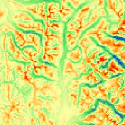
מדד ה-mTPI מבחין בין צורות של רכסים לבין צורות של עמקים. החישוב מתבצע באמצעות נתוני הגובה של כל מיקום, פחות הגובה הממוצע בשכונה. בחישוב mTPI נעשה שימוש בחלונות נעים ברדיוס (ק"מ): 115.8, 89.9, 35.5, 13.1, 5.6, 2.8 ו-1.2. הוא מבוסס על NED DEM של USGS (זמין ב-EE בתור USGS/NED).
מערכי הנתונים, צורות הנוף והפיזיוגרפיה של Conservation Science Partners (שותפי מדעי השימור, CSP) Ecologically Relevant Geomorphology (גאומורפולוגיה רלוונטית מבחינה אקולוגית, ERGo) מכילים נתונים מפורטים ורב-קנה מידה על צורות נוף ודפוסים פיזיוגרפיים (שנקראים גם פני שטח). אף על פי שיש הרבה שימושים פוטנציאליים לנתונים האלה, המטרה המקורית שלהם הייתה לפתח סיווג ומפה רלוונטיים מבחינה אקולוגית של צורות נוף וסיווגים פיזיוגרפיים שמתאימים לתכנון הסתגלות לאקלים. מכיוון שיש אי ודאות רבה לגבי תנאי האקלים העתידיים, ועוד יותר אי ודאות לגבי תגובות אקולוגיות, מידע על מה שלא צפוי להשתנות מספק בסיס חזק למנהלים לבניית תוכניות חזקות להתאמה לאקלים. הכמות של התכונות האלה בנוף תלויה ברזולוציה, ולכן אנחנו מספקים את הרזולוציה הגבוהה ביותר שאפשר בהתחשב בהיקף ובמאפיינים של אינדקס נתון.
תחום תדרים
תחום תדרים
גודל הפיקסל: 270 מטרים (כל הפסים)
| שם | יחידות | מינימום | מקסימום | גודל הפיקסל | תיאור |
|---|---|---|---|---|---|
elevation |
m | -378 | 493 | 270 מטרים | ערכי mTPI שנגזרים מ-NED, בטווח שבין ערכים שליליים (עמקים) לחיוביים (רכסים) |
תנאים והגבלות
תנאים והגבלות
ציטוטים ביבליוגרפיים
Theobald, D. M., Harrison-Atlas, D., Monahan, W. B., & Albano, C. מ. (2015). מפות רלוונטיות מבחינה אקולוגית של צורות נוף ומגוון פיזיוגרפי לתכנון היערכות לשינויי האקלים. PloS one, 10(12), e0143619
סיור עם פלטפורמת Earth Engine
עורך קוד (JavaScript)
var dataset = ee.Image('CSP/ERGo/1_0/US/mTPI');
var usMtpi = dataset.select('elevation');
var usMtpiVis = {
  min: -200.0,
  max: 200.0,
  palette: ['0b1eff', '4be450', 'fffca4', 'ffa011', 'ff0000'],
};
Map.setCenter(-105.8636, 40.3439, 11);
Map.addLayer(usMtpi, usMtpiVis, 'US mTPI');