- Dostępność zbioru danych
- 2016-01-01T00:00:00Z–2016-12-31T00:00:00Z
- Dostawca zbioru danych
- Conservation Science Partners
- Częstotliwość
- 1 rok
- Tagi
Opis
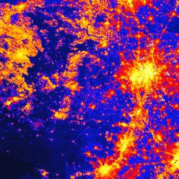
Globalny zbiór danych o zmianach spowodowanych przez człowieka (gHM) zawiera skumulowane dane o zmianach na lądach na całym świecie w rozdzielczości 1 km kwadratowego. Wartości gHM wahają się od 0,0 do 1,0 i są obliczane na podstawie szacunkowego odsetka danego miejsca (piksela), które zostało zmodyfikowane, oraz szacunkowej intensywności modyfikacji związanej z danym typem modyfikacji przez człowieka lub „stresora”. 5 głównych czynników stresogennych pochodzenia antropogenicznego z okresu około 2016 roku zostało zmapowanych na podstawie 13 indywidualnych zbiorów danych:
- osadnictwo (gęstość zaludnienia, obszary zabudowane);
- rolnictwo (uprawy, hodowla zwierząt);
- transport (główne, drugorzędne i dwutorowe drogi oraz linie kolejowe);
- górnictwo i produkcja energii,
- infrastruktura elektryczna (linie energetyczne, oświetlenie nocne);
Więcej szczegółów metodologicznych znajdziesz w tej publikacji. Ten zasób został przekształcony do układu WGS84 na potrzeby Earth Engine.
Pasma
Pasma
Rozmiar piksela: 1000 m (wszystkie pasma)
| Nazwa | Jednostki | Min. | Maks. | Rozmiar piksela | Opis |
|---|---|---|---|---|---|
gHM |
km² | 0 | 1 | 1 000 metrów | globalne modyfikacje ludzkie, |
Warunki korzystania z usługi
Warunki korzystania z usługi
Cytaty
Kennedy, C.M., J.R. Oakleaf, D.M. Theobald, S. Baruch-Murdo i J. Kiesecker. 2019 r. Managing the middle: A shift in conservation priorities based on the global human modification gradient. Global Change Biology 00:1-16. doi:10.1111/gcb.14549
Odkrywaj za pomocą Earth Engine
Edytor kodu (JavaScript)
var dataset = ee.ImageCollection('CSP/HM/GlobalHumanModification');

var visualization = {
  bands: ['gHM'],
  min: 0.0,
  max: 1.0,
  palette: ['0c0c0c', '071aff', 'ff0000', 'ffbd03', 'fbff05', 'fffdfd']
};

Map.centerObject(dataset);

Map.addLayer(dataset, visualization, 'Human modification');