গ্লোবাল অ্যাডমিনিস্ট্রেটিভ ইউনিট লেয়ারস (GAUL) বিশ্বের সমস্ত দেশের জন্য প্রশাসনিক ইউনিটের সেরা উপলব্ধ তথ্য সংকলন করে এবং প্রচার করে, যা প্রশাসনিক ইউনিটগুলির প্রতিনিধিত্বকারী স্থানিক ডেটাসেটের প্রমিতকরণে অবদান রাখে। GAUL সর্বদা দেশে, প্রথম (যেমন বিভাগ) এবং দ্বিতীয় প্রশাসনিক স্তরে (যেমন জেলা) একটি ইউনিফাইড কোডিং সিস্টেমের সাথে বিশ্বব্যাপী স্তরগুলি বজায় রাখে। যেখানে ডেটা পাওয়া যায়, এটি দেশের ভিত্তিতে তৃতীয়, চতুর্থ এবং নিম্ন স্তরে স্তর সরবরাহ করে। সামগ্রিক পদ্ধতির মধ্যে রয়েছে ক) সবচেয়ে নির্ভরযোগ্য উত্স থেকে সেরা উপলব্ধ ডেটা সংগ্রহ করা, খ) ভৌগলিক বৈশিষ্ট্যগুলির বৈধতা সময়কাল প্রতিষ্ঠা করা (যখন সম্ভব), গ) ইউএন কার্টোগ্রাফিক ইউনিট (ইউএনসিএস) দ্বারা প্রদত্ত শেষ দেশের সীমানা মানচিত্রের উপর ভিত্তি করে বিশ্ব স্তরে নির্বাচিত ডেটা যুক্ত করা, ঘ) GAUL কোডিং সিস্টেম ব্যবহার করে কোড তৈরি করা এবং ব্যবহারকারীদের echnical ডেটা ডিসপেক্ট করা GAUL ডিস্ট্রিবিউশন সেট মনে রাখবেন যে কিছু প্রশাসনিক ইউনিট বহুভুজ বৈশিষ্ট্য।
টেবিল স্কিমা
টেবিল স্কিমা
নাম
টাইপ
বর্ণনা
ADM0_CODE
আইএনটি
GAUL দেশের কোড
ADM0_NAME
STRING
জাতিসংঘের দেশের নাম
DISP_AREA
STRING
অস্থির অঞ্চল: 'হ্যাঁ' বা 'না'
স্ট্যাটাস
STRING
দেশের অবস্থা
আকৃতি_ক্ষেত্র
দ্বিগুণ
আকৃতির এলাকা
আকৃতি_লেং
দ্বিগুণ
আকৃতির দৈর্ঘ্য
ADM1_CODE
আইএনটি
প্রথম স্তরে প্রশাসনিক ইউনিটের GAUL কোড
ADM1_NAME
STRING
প্রথম স্তরে প্রশাসনিক ইউনিটের নাম
ADM2_CODE
আইএনটি
দ্বিতীয় স্তরে প্রশাসনিক ইউনিটের GAUL কোড
ADM2_NAME
STRING
দ্বিতীয় স্তরে প্রশাসনিক ইউনিটের নাম
EXP2_YEAR
আইএনটি
প্রশাসনিক ইউনিটের মেয়াদ শেষ হওয়ার বছর
STR2_YEAR
আইএনটি
প্রশাসনিক ইউনিটের সৃষ্টি বছর
ব্যবহারের শর্তাবলী
ব্যবহারের শর্তাবলী
GAUL ডেটাসেট জাতিসংঘ এবং অন্যান্য অনুমোদিত আন্তর্জাতিক এবং জাতীয় প্রতিষ্ঠান/এজেন্সিগুলিতে বিতরণ করা হয়। FAO শুধুমাত্র অ-বাণিজ্যিক উদ্দেশ্যে এবং ডেটা লাইসেন্সে উল্লিখিত শর্তাবলী অনুসারে GAUL ডেটাসেটে থাকা উপকরণগুলি ব্যবহার, ডাউনলোড এবং মুদ্রণের জন্য লাইসেন্স প্রদান করে। সম্পূর্ণ GAUL ডেটা লাইসেন্স নথি ডাউনলোড করার জন্য উপলব্ধ। এছাড়াও দাবিত্যাগ দেখুন.
গ্লোবাল অ্যাডমিনিস্ট্রেটিভ ইউনিট লেয়ারস (GAUL) বিশ্বের সমস্ত দেশের জন্য প্রশাসনিক ইউনিটের সেরা উপলব্ধ তথ্য সংকলন করে এবং প্রচার করে, যা প্রশাসনিক ইউনিটগুলির প্রতিনিধিত্বকারী স্থানিক ডেটাসেটের প্রমিতকরণে অবদান রাখে। GAUL সর্বদা দেশে একটি ইউনিফাইড কোডিং সিস্টেমের সাথে বিশ্বব্যাপী স্তরগুলি বজায় রাখে, প্রথমে ...
FAO/GAUL/2015/level2, সীমানা, কাউন্টি, জেলা, fao, gaul, অবকাঠামো-সীমানা, টেবিল, un
[null,null,[],[[["\u003cp\u003eThe FAO GAUL dataset provides global administrative unit boundaries at the country, first, and second administrative levels (e.g., districts).\u003c/p\u003e\n"],["\u003cp\u003eIt includes attributes such as administrative unit codes, names, status, and creation/expiry years.\u003c/p\u003e\n"],["\u003cp\u003eThe dataset is intended for non-commercial use with a specific data license available for review.\u003c/p\u003e\n"],["\u003cp\u003eUsers can access and analyze the dataset within Google Earth Engine for research, education, and nonprofit purposes.\u003c/p\u003e\n"],["\u003cp\u003eThe dataset is available as a FeatureCollection and as a pre-rendered FeatureView for faster visualization.\u003c/p\u003e\n"]]],[],null,["# FAO GAUL: Global Administrative Unit Layers 2015, Second-Level Administrative Units\n\nDataset Availability\n: 2014-12-19T16:45:00Z--2014-12-19T16:45:00Z\n\nDataset Provider\n:\n\n\n [FAO UN](https://www.fao.org/geonetwork/srv/en/metadata.show?id=12691)\n\nTags\n:\n[borders](/earth-engine/datasets/tags/borders) [county](/earth-engine/datasets/tags/county) [districts](/earth-engine/datasets/tags/districts) [fao](/earth-engine/datasets/tags/fao) [gaul](/earth-engine/datasets/tags/gaul) [infrastructure-boundaries](/earth-engine/datasets/tags/infrastructure-boundaries) [table](/earth-engine/datasets/tags/table) [un](/earth-engine/datasets/tags/un) \n\n#### Description\n\nThe Global Administrative Unit Layers (GAUL) compiles and disseminates the\nbest available information on administrative units for all the countries in\nthe world, providing a contribution to the standardization of the spatial\ndataset representing administrative units. The GAUL always maintains global\nlayers with a unified coding system at country, first (e.g. departments),\nand second administrative levels (e.g. districts). Where data is available,\nit provides layers on a country by country basis down to third, fourth, and\nlowers levels. The overall methodology consists in a) collecting the best\navailable data from most reliable sources, b) establishing validation\nperiods of the geographic features (when possible), c) adding selected data\nto the global layer based on the last country boundaries map provided by\nthe UN Cartographic Unit (UNCS), d) generating codes using GAUL Coding\nSystem, and e) distribute data to the users\n(see [Technical Aspects of the GAUL Distribution Set](https://data.apps.fao.org:/map/catalog/srv/api/records/9c35ba10-5649-41c8-bdfc-eb78e9e65654/attachments/GAUL2015_Documentation.zip).\nNote that some administrative units are multipolygon features.\n\n### Table Schema\n\n**Table Schema**\n\n| Name | Type | Description |\n|------------|--------|---------------------------------------------------|\n| ADM0_CODE | INT | GAUL country code |\n| ADM0_NAME | STRING | UN country name |\n| DISP_AREA | STRING | Unsettled territory: 'Yes' or 'No' |\n| STATUS | STRING | Status of the country |\n| Shape_Area | DOUBLE | Shape area |\n| Shape_Leng | DOUBLE | Shape length |\n| ADM1_CODE | INT | GAUL code of administrative units at first level |\n| ADM1_NAME | STRING | Name of administrative units at first level |\n| ADM2_CODE | INT | GAUL code of administrative units at second level |\n| ADM2_NAME | STRING | Name of administrative units at second level |\n| EXP2_YEAR | INT | Expiry year of the administrative unit |\n| STR2_YEAR | INT | Creation year of the administrative unit |\n\n### Terms of Use\n\n**Terms of Use**\n\nThe GAUL dataset is distributed to the United Nations and other authorized\ninternational and national institutions/agencies. FAO grants a license to\nuse, download and print the materials contained in the GAUL dataset solely\nfor non-commercial purposes and in accordance with the conditions specified\nin the data license.\n[The full GAUL Data License document](https://developers.google.com/earth-engine/datasets/catalog/DataLicenseGAUL2015.pdf)\nis available for downloading. See also\n[the disclaimer](https://developers.google.com/earth-engine/datasets/catalog/DisclaimerGAUL2015.pdf).\n\n### Explore with Earth Engine\n\n| **Important:** Earth Engine is a platform for petabyte-scale scientific analysis and visualization of geospatial datasets, both for public benefit and for business and government users. Earth Engine is free to use for research, education, and nonprofit use. To get started, please [register for Earth Engine access.](https://console.cloud.google.com/earth-engine)\n\n### Code Editor (JavaScript)\n\n```javascript\n
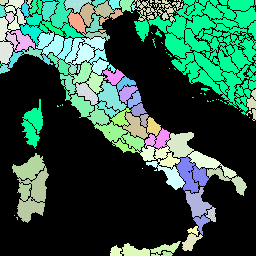
var dataset = ee.FeatureCollection('FAO/GAUL/2015/level2');\n\nMap.setCenter(12.876, 42.682, 5);\n\nvar styleParams = {\n fillColor: 'b5ffb4',\n color: '00909F',\n width: 1.0,\n};\n\ndataset = dataset.style(styleParams);\n\nMap.addLayer(dataset, {}, 'Second Level Administrative Units');\n```\n[Open in Code Editor](https://code.earthengine.google.com/?scriptPath=Examples:Datasets/FAO/FAO_GAUL_2015_level2)\n\n### Visualize as a FeatureView\n\n\nA `FeatureView` is a view-only, accelerated representation of a\n`FeatureCollection`. For more details, visit the\n[`FeatureView` documentation.](/earth-engine/guides/featureview_overview)\n| **Important:** Earth Engine is a platform for petabyte-scale scientific analysis and visualization of geospatial datasets, both for public benefit and for business and government users. Earth Engine is free to use for research, education, and nonprofit use. To get started, please [register for Earth Engine access.](https://console.cloud.google.com/earth-engine)\n\n### Code Editor (JavaScript)\n\n```javascript\nvar fvLayer = ui.Map.FeatureViewLayer('FAO/GAUL/2015/level2_FeatureView');\n\nvar visParams = {\n color: '00909F',\n fillColor: 'b5ffb4',\n opacity: 1,\n width: 1,\n pointSize: 1\n};\n\nfvLayer.setVisParams(visParams);\nfvLayer.setName('Second Level Administrative Units');\n\nMap.setCenter(7.82, 49.1, 4);\nMap.add(fvLayer);\n```\n[Open in Code Editor](https://code.earthengine.google.com/?scriptPath=Examples:Datasets/FAO/FAO_GAUL_2015_level2_FeatureView) \n[FAO GAUL: Global Administrative Unit Layers 2015, Second-Level Administrative Units](/earth-engine/datasets/catalog/FAO_GAUL_2015_level2) \nThe Global Administrative Unit Layers (GAUL) compiles and disseminates the best available information on administrative units for all the countries in the world, providing a contribution to the standardization of the spatial dataset representing administrative units. The GAUL always maintains global layers with a unified coding system at country, first ... \nFAO/GAUL/2015/level2, borders,county,districts,fao,gaul,infrastructure-boundaries,table,un \n2014-12-19T16:45:00Z/2014-12-19T16:45:00Z \n-90 -180 90 180 \nGoogle Earth Engine \nhttps://developers.google.com/earth-engine/datasets\n\n- [](https://doi.org/https://www.fao.org/geonetwork/srv/en/metadata.show?id=12691)\n- [](https://doi.org/https://developers.google.com/earth-engine/datasets/catalog/FAO_GAUL_2015_level2)"]]