- Dostępność zbioru danych
- 2000-01-01T00:00:00Z–2000-12-31T00:00:00Z
- Dostawca zbioru danych
- Ośrodek NASA LP DAAC w USGS EROS Center
- Tagi
Opis
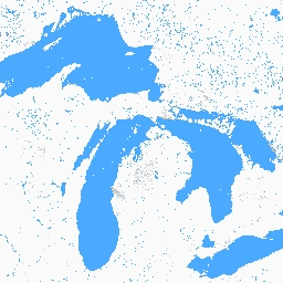
Zbiór danych Global Inland Water przedstawia śródlądowe zbiorniki wodne, w tym jeziora słodkie i słone, rzeki i zbiorniki.
Od epoki GLS 2000 zidentyfikowano 3 650 723 km² wód śródlądowych, z czego około trzy czwarte znajdowało się w Ameryce Północnej i Azji. Największą część wód śródlądowych stanowią lasy borealne i tundra – około 40% całości. Dane wykazują silną korelację liniową zarówno ze zbiorem danych MODIS, jak i ze zbiorami danych o rozdzielczości 30 m w Stanach Zjednoczonych i Kanadzie. Błędy resztkowe wynikały głównie z sezonowości pokrywy wodnej, śniegu i lodu oraz chmur resztkowych.
Zbiór danych zawiera co najmniej 1 obraz dla każdej dostępnej ścieżki/wiersza Landsat WRS2.
Dokumentacja:
Pasma
Pasma
Rozmiar piksela: 30 m (wszystkie pasma)
| Nazwa | Rozmiar piksela | Opis |
|---|---|---|
water |
30 metrów | Klasyfikacja wody |
Tabela klasy wody
| Wartość | Kolor | Opis |
|---|---|---|
| 1 | #fafafa | Ląd |
| 2 | #00c5ff | Woda |
| 4 | #df73ff | Śnieg/oblodzenie |
| 200 | #828282 | Cień chmury |
| 201 | #cccccc | Chmura |
Właściwości obrazu
Właściwości obrazu
| Nazwa | Typ | Opis |
|---|---|---|
| ścieżka | LICZBA ZMIENNOPRZECINKOWA O PODWÓJNEJ PRECYZJI | Ścieżka |
| ścieżka | CIĄG ZNAKÓW | Ścieżka i rząd |
| wiersz | LICZBA ZMIENNOPRZECINKOWA O PODWÓJNEJ PRECYZJI | Wiersz |
| water_class_names | LICZBA ZMIENNOPRZECINKOWA O PODWÓJNEJ PRECYZJI | Nazwy zajęć |
| water_class_palette | LICZBA ZMIENNOPRZECINKOWA O PODWÓJNEJ PRECYZJI | Paleta klas wody |
| water_class_values | INT_LIST | Wartości klasy wody |
Warunki korzystania z usługi
Warunki korzystania z usługi
Prawa własności intelektualnej do tego zbioru danych należą do University of Maryland, Department of Geographical Sciences i NASA. Korzystanie jest bezpłatne, jeśli zostanie podane źródło.
Cytaty
Cytowanie danych: Global Inland Water, {Year, ...}, Global Land Cover Facility.
Cytowanie artykułu/metod: Feng, Min, Joseph O. Sexton, Saurabh Channan i John R. Townshend. 2015 r. A Global, High-Resolution (30-M) Inland Water Body Dataset for 2000: First Results of a Topographic-Spectral Classification Algorithm. International Journal of Digital Earth. doi:10.1080/17538947.2015.1026420.
DOI
Odkrywaj za pomocą Earth Engine
Edytor kodu (JavaScript)
var dataset = ee.ImageCollection('GLCF/GLS_WATER');
var water = dataset.select('water');
var waterVis = {
  min: 1.0,
  max: 4.0,
  palette: ['fafafa', '00c5ff', 'df73ff', '828282', 'cccccc'],
};
Map.setCenter(-79.3094, 44.5693, 8);
Map.addLayer(water, waterVis, 'Water');