-
GLCF: Landsat Global Inland Water
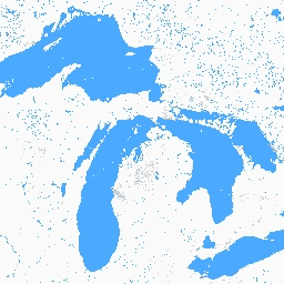
Zbiór danych Global Inland Water przedstawia śródlądowe zbiorniki wodne, w tym jeziora słodkie i słone, rzeki i zbiorniki. W okresie GLS 2000 zidentyfikowano 3 650 723 km² wód śródlądowych, z czego około trzy czwarte znajdowało się w Ameryce Północnej i Azji. tajga i tundra… glcf landsat-derived nasa surface-ground-water umd water -
Global Forest Cover Change (GFCC) Tree Cover Multi-Year Global 30m
Warstwy pokrycia drzewami Landsat Vegetation Continuous Fields (VCF) zawierają szacunki procentowego pokrycia terenu w każdym pikselu o rozmiarze 30 m przez roślinność drzewiastą o wysokości powyżej 5 metrów. Zbiór danych jest dostępny w 4 epokach, których środki przypadają na lata 2000, 2005, 2010 … forest forest-biomass glcf landsat-derived nasa umd
Datasets tagged glcf in Earth Engine
[null,null,[],[],[]]