- Dostępność zbioru danych
- 2000-01-01T00:00:00Z–2015-01-01T00:00:00Z
- Dostawca zbioru danych
- Ośrodek NASA LP DAAC w USGS EROS Center
- Częstotliwość
- 5 lat
- Tagi
Opis
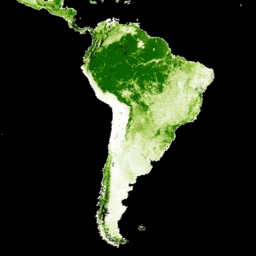
Warstwy zagęszczenia drzew w zbiorze danych Landsat Vegetation Continuous Fields (VCF) zawierają szacunki procentowego pokrycia powierzchni ziemi w każdym pikselu o rozmiarze 30 m przez roślinność drzewiastą o wysokości powyżej 5 m. Zbiór danych jest dostępny w przypadku 4 okresów, których środki przypadają na lata 2000, 2005, 2010 i 2015. Zbiór danych pochodzi z produktu GFCC Surface Reflectance (GFCC30SR), który jest oparty na ulepszonych zbiorach danych Global Land Survey (GLS). Zbiory danych GLS składają się z obrazów o wysokiej rozdzielczości z satelitów Landsat 5 (skaner tematyczny TM) i Landsat 7 (ulepszony skaner tematyczny ETM+) w rozdzielczości 30 m.
Zagęszczenie drzew, czyli proporcjonalny, pionowo rzutowany obszar roślinności (w tym liści, pędów, gałęzi itp.) roślin drzewiastych powyżej określonej wysokości, wpływa na wymianę energii i wody na lądzie, fotosyntezę i transpirację, pierwotną produkcję netto oraz przepływy węgla i składników odżywczych. Pokrywa drzew również wpływa na jakość siedlisk i przemieszczanie się dzikich zwierząt, wartość nieruchomości mieszkalnych dla ludzi i inne usługi ekosystemowe. Ciągły schemat klasyfikacji produktu VCF umożliwia lepsze przedstawienie gradientów pokrycia terenu niż tradycyjne schematy klasyfikacji dyskretnej. Ważne dla wykrywania i monitorowania zmian w lasach (np. wylesiania i degradacji) jest to, że zagęszczenie drzew stanowi mierzalny atrybut, na podstawie którego można określić pokrywę leśną i jej zmiany. Zmiany zagęszczenia drzew na przestrzeni czasu mogą być wykorzystywane do monitorowania i pobierania historii zmian w lesie w określonych lokalizacjach.
Zbiór danych został utworzony dla 4-letnich okresów: 2000, 2005, 2010 i 2015 r. Zawiera on obraz w kolekcji dla każdej dostępnej ścieżki/wiersza WRS2.
Dokumentacja:
Uwaga dostawcy: z powodu zakończenia finansowania przez NASA MEaSUREs bezpłatne wersje tego zbioru danych nie są już tworzone. Zainteresowane strony mogą uzyskać zaktualizowane i rozszerzone wersje na stronie www.terraPulse.com.
Pasma
Pasma
Rozmiar piksela: 30 m (wszystkie pasma)
| Nazwa | Jednostki | Min. | Maks. | Rozmiar piksela | Opis |
|---|---|---|---|---|---|
tree_canopy_cover |
% | 0 | 100 | 30 metrów | Odsetek powierzchni pikseli pokrytej drzewami. |
uncertainty |
30 metrów | RMSE dla tree-canopy_cover |
|||
source_index |
30 metrów | Tożsamość obrazu źródłowego użytego w przypadku danego piksela. Jest to indeks w tablicy metadanych poszczególnych obrazów „sources”. Dostępne tylko w przypadku lat 2000, 2005 i 2010. |
Właściwości obrazu
Właściwości obrazu
| Nazwa | Typ | Opis |
|---|---|---|
| ścieżka | LICZBA ZMIENNOPRZECINKOWA O PODWÓJNEJ PRECYZJI | Ścieżka |
| ścieżka | CIĄG ZNAKÓW | Ścieżka i rząd |
| wiersz | LICZBA ZMIENNOPRZECINKOWA O PODWÓJNEJ PRECYZJI | Wiersz |
| źródła | LICZBA ZMIENNOPRZECINKOWA O PODWÓJNEJ PRECYZJI | Źródła. Dostępne tylko w przypadku lat 2000, 2005 i 2010. |
| tree_canopy_cover_class_palette | LICZBA ZMIENNOPRZECINKOWA O PODWÓJNEJ PRECYZJI | Paleta klas pokrycia zagęszczenia drzew |
| tree_canopy_cover_class_values | LICZBA ZMIENNOPRZECINKOWA O PODWÓJNEJ PRECYZJI | Wartości klasy pokrycia zagęszczenia drzew |
| rok | LICZBA ZMIENNOPRZECINKOWA O PODWÓJNEJ PRECYZJI | Rok |
Warunki korzystania z usługi
Warunki korzystania z usługi
Prawa własności intelektualnej do tego zbioru danych należą do University of Maryland, Department of Geographical Sciences i NASA. Korzystanie z nich jest bezpłatne pod warunkiem podania informacji o autorze.
Cytaty
Cytowanie artykułu/metod: Sexton, J. O., Song, X.-P., Feng, M., Noojipady, P., Anand, A., Huang, C., Kim, D.-H., Collins, K.M., Channan, S., DiMiceli, C., Townshend, J.R.G. (2013). Globalne, ciągłe pola zagęszczenia drzew w rozdzielczości 30 m: przeskalowane na podstawie danych z satelity Landsat ciągłe pola roślinności MODIS z oszacowaniami błędów na podstawie danych z lidaru. International Journal of Digital Earth, 130321031236007. doi:10.1080/17538947.2013.786146.
DOI
Odkrywaj za pomocą Earth Engine
Edytor kodu (JavaScript)
var dataset = ee.ImageCollection('NASA/MEASURES/GFCC/TC/v3')
                  .filter(ee.Filter.date('2015-01-01', '2015-12-31'));
var treeCanopyCover = dataset.select('tree_canopy_cover');
var treeCanopyCoverVis = {
  min: 0.0,
  max: 100.0,
  palette: ['ffffff', 'afce56', '5f9c00', '0e6a00', '003800'],
};
Map.setCenter(-88.6, 26.4, 3);
Map.addLayer(treeCanopyCover.mean(), treeCanopyCoverVis, 'Tree Canopy Cover');