Global Land Ice Measurements from Space (GLIMS) es una iniciativa internacional cuyo objetivo es realizar estudios repetidos de los aproximadamente 200,000 glaciares del mundo.
El proyecto busca crear un inventario integral a nivel mundial del hielo terrestre, incluidas las mediciones del área, la geometría, la velocidad de la superficie y la elevación de la línea de nieve de los glaciares. Para realizar estos análisis, el proyecto GLIMS utiliza datos satelitales, principalmente del Radiómetro Avanzado de Emisión y Reflexión Térmica Aerotransportado (ASTER) y el Explorador Temático Mejorado Plus (ETM+) de Landsat, así como información histórica derivada de mapas y fotografías aéreas.
Cada elemento de este conjunto de datos es un límite poligonal de un glaciar en el momento del análisis. Algunos IDs de glaciares tienen cientos de filas distintas a lo largo del tiempo.
Este conjunto de datos es una instantánea del inventario de los límites de los glaciares al 7 de junio de 2023, y proporciona más de 1,100,000 filas.
Esquema de la tabla
Esquema de la tabla
Nombre
Tipo
Descripción
analistas
STRING
Nombres de los colaboradores de datos
anlys_id
DOUBLE
ID de un glaciar en un momento determinado
anlys_time
STRING
Cuándo se realizó el análisis
área
DOUBLE
Área del glaciar en el plano de la proyección del mapa en kilómetros cuadrados
chief_affl
STRING
Afiliación del jefe del centro regional
db_area
DOUBLE
Es igual que "area", pero se vuelve a calcular con el proyecto de GLIMS.
geog_area
STRING
Nombre de la región geográfica que abarca el centro regional
glac_id
STRING
ID de glaciar de GLIMS
glac_name
STRING
Es el nombre del glaciar. Alrededor del 80% de las filas son iguales a "None".
glac_stat
STRING
Estado de Glacier, que puede ser "exists" o "None"
longitud
DOUBLE
Longitud del perímetro del glaciar en metros
line_type
STRING
Tipo de registro de glaciar, p.ej., "glac_bound" para glaciares, o bien otros valores para rocas internas, líneas de nieve, accidentes geográficos acuáticos, etc.
local_id
STRING
ID asignado por la institución colaboradora o el centro regional
max_elev
DOUBLE
Parte más alta del glaciar, en metros sobre el nivel del mar
mean_elev
DOUBLE
Elevación media del glaciar, en metros sobre el nivel del mar
min_elev
DOUBLE
Parte más baja del glaciar, en metros sobre el nivel del mar
ID del padre
STRING
ID del glaciar principal de este glaciar
primeclass
DOUBLE
Número de clasificación de glaciares del WGMS
proc_desc
STRING
Descripción del tratamiento de datos que se realiza en este registro
rc_id
DOUBLE
ID que usa el centro regional
rec_status
STRING
Estado de registro
release_dt
STRING
Fecha en que se publicaron los datos, en formato aaaa-MM-ddTHH:mm:ss
src_date
STRING
Fecha de las imágenes de origen que se usaron para crear el esquema
subm_id
DOUBLE
ID de envío asignado por GLIMS
Remitentes
STRING
Nombre(s) de quien envía los datos
wgms_id
STRING
ID del Servicio Mundial de Supervisión de Glaciares
ancho
DOUBLE
Ancho del glaciar en metros
Condiciones de Uso
Condiciones de Uso
Para la creación de informes, publicaciones, conjuntos de datos nuevos, productos derivados o servicios que resulten del conjunto de datos, los usuarios deben citar: GLIMS y NSIDC (2005, actualizado en 2013): Base de datos de glaciares de mediciones globales de hielo terrestre desde el espacio. Compilado y puesto a disposición por la comunidad internacional de GLIMS y el Centro Nacional de Datos sobre Nieve y Hielo, Boulder, CO, EE.UU., doi:10.7265/N5V98602
Un FeatureView es una representación acelerada y de solo lectura de un FeatureCollection. Para obtener más detalles, consulta la
documentación de FeatureView.
Global Land Ice Measurements from Space (GLIMS) es una iniciativa internacional cuyo objetivo es realizar estudios repetidos de los aproximadamente 200,000 glaciares del mundo. El proyecto busca crear un inventario integral a nivel mundial del hielo terrestre, incluidas las mediciones del área, la geometría, la velocidad de la superficie y la elevación de la línea de nieve de los glaciares. Para realizar estos análisis, …
[null,null,[],[[["\u003cp\u003e\u003cstrong\u003eCaution:\u003c/strong\u003e This dataset has been replaced by a newer version, GLIMS/20230607.\u003c/p\u003e\n"],["\u003cp\u003eGLIMS is an international project creating a global inventory of glacier boundaries, including measurements of glacier area, geometry, velocity, and snow line elevation.\u003c/p\u003e\n"],["\u003cp\u003eThe dataset comprises over 1,100,000 rows, representing glacier boundaries primarily derived from ASTER and Landsat satellite data.\u003c/p\u003e\n"],["\u003cp\u003eEach feature in the dataset represents a glacier's polygonal boundary at the time of analysis, with attributes like area, elevation, and source imagery date.\u003c/p\u003e\n"],["\u003cp\u003eUsers of this dataset for publications or derived products should cite GLIMS and NSIDC, providing the associated DOI.\u003c/p\u003e\n"]]],[],null,["# GLIMS Current: Global Land Ice Measurements From Space\n\nDataset Availability\n: 1750-01-01T00:00:00Z--2023-06-07T00:00:00Z\n\nDataset Provider\n:\n\n\n [National Snow and Ice Data Center (NSDIC)](https://www.glims.org)\n\nTags\n:\n[cryosphere](/earth-engine/datasets/tags/cryosphere) [glacier](/earth-engine/datasets/tags/glacier) [glims](/earth-engine/datasets/tags/glims) [ice](/earth-engine/datasets/tags/ice) [landcover](/earth-engine/datasets/tags/landcover) [nasa](/earth-engine/datasets/tags/nasa) [nsidc](/earth-engine/datasets/tags/nsidc) [snow](/earth-engine/datasets/tags/snow) [table](/earth-engine/datasets/tags/table) \n\n#### Description\n\nGlobal Land Ice Measurements from Space (GLIMS) is\nan international initiative with the goal of repeatedly surveying\nthe world's estimated 200,000 glaciers.\n\nThe project seeks\nto create a globally comprehensive inventory of land ice, including\nmeasurements of glacier area, geometry, surface velocity, and\nsnow line elevation. To perform these analyses, the GLIMS project\nuses satellite data, primarily from the Advanced Spaceborne Thermal\nEmission and Reflection Radiometer (ASTER) and the Landsat Enhanced\nThematic Mapper Plus (ETM+), as well as historical information\nderived from maps and aerial photographs.\n\nEach feature in this dataset is a polygonal boundary of a glacier at the\ntime of analysis. A few glacier IDs have hundreds of distinct rows over\ntime.\n\nThis dataset is a snapshot of the inventory of glacier boundaries as of\nJune 7, 2023, providing over 1,100,000 rows.\n\n### Table Schema\n\n**Table Schema**\n\n| Name | Type | Description |\n|------------|--------|--------------------------------------------------------------------------------------------------------------------------|\n| analysts | STRING | Name(s) of data contributor(s) |\n| anlys_id | DOUBLE | ID of a glacier at a particular time |\n| anlys_time | STRING | When the analysis was done |\n| area | DOUBLE | Area of the glacier in the plane of the map projection in square kilometers |\n| chief_affl | STRING | Affiliation of the chief of the regional center |\n| db_area | DOUBLE | Same as 'area', but recomputed by the GLIMS project |\n| geog_area | STRING | Name of geographic region covered by the regional center |\n| glac_id | STRING | The GLIMS glacier ID |\n| glac_name | STRING | The glacier name. \\~80% of the rows equal 'None' |\n| glac_stat | STRING | Glacier status, either 'exists' or 'None' |\n| length | DOUBLE | Length of the glacier perimeter in meters |\n| line_type | STRING | Glacier record type, e.g. 'glac_bound' for glaciers, or other values for internal rocks, snowlines, water features, etc. |\n| local_id | STRING | ID assigned by the contributing institution or regional center |\n| max_elev | DOUBLE | Highest part of the glacier, in meters above sea level |\n| mean_elev | DOUBLE | Mean elevation of the glacier, in meters above sea level |\n| min_elev | DOUBLE | Lowest part of the glacier, in meters above sea level |\n| parent_id | STRING | ID of the glacier that is the parent of this glacier |\n| primeclass | DOUBLE | WGMS glacier classification number |\n| proc_desc | STRING | Description of processing done on this record |\n| rc_id | DOUBLE | ID used by the regional center |\n| rec_status | STRING | Record status |\n| release_dt | STRING | Date data was released, in YYYY-MM-ddTHH:mm:ss format |\n| src_date | STRING | Date of source imagery used to create the outline |\n| subm_id | DOUBLE | The submission ID assigned by GLIMS |\n| submitters | STRING | Name(s) of data submitter(s) |\n| wgms_id | STRING | World Glacier Monitoring Service ID |\n| width | DOUBLE | Width of the glacier in meters |\n\n### Terms of Use\n\n**Terms of Use**\n\nFor the creation of any reports, publications, new\ndata sets, derived products, or services resulting from the data\nset, users should cite: GLIMS and NSIDC (2005, updated 2013): Global\nLand Ice Measurements from Space glacier database. Compiled and\nmade available by the international GLIMS community and the National\nSnow and Ice Data Center, Boulder CO, U.S.A.,\n[doi:10.7265/N5V98602](https://doi.org/10.7265/N5V98602)\n\n### DOIs\n\n- \u003chttps://doi.org/10.7265/N5V98602\u003e\n\n### Explore with Earth Engine\n\n| **Important:** Earth Engine is a platform for petabyte-scale scientific analysis and visualization of geospatial datasets, both for public benefit and for business and government users. Earth Engine is free to use for research, education, and nonprofit use. To get started, please [register for Earth Engine access.](https://console.cloud.google.com/earth-engine)\n\n### Code Editor (JavaScript)\n\n```javascript\n
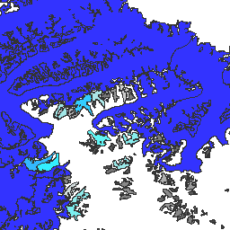
var dataset = ee.FeatureCollection('GLIMS/current');\nvar visParams = {\n palette: ['gray', 'cyan', 'blue'],\n min: 0.0,\n max: 10.0,\n opacity: 0.8,\n};\nvar image = ee.Image().float().paint(dataset, 'area');\nMap.setCenter(-35.618, 66.743, 7);\nMap.addLayer(image, visParams, 'GLIMS/current');\nMap.addLayer(dataset, null, 'for Inspector', false);\n```\n[Open in Code Editor](https://code.earthengine.google.com/?scriptPath=Examples:Datasets/GLIMS/GLIMS_current)\n\n### Visualize as a FeatureView\n\n\nA `FeatureView` is a view-only, accelerated representation of a\n`FeatureCollection`. For more details, visit the\n[`FeatureView` documentation.](/earth-engine/guides/featureview_overview)\n| **Important:** Earth Engine is a platform for petabyte-scale scientific analysis and visualization of geospatial datasets, both for public benefit and for business and government users. Earth Engine is free to use for research, education, and nonprofit use. To get started, please [register for Earth Engine access.](https://console.cloud.google.com/earth-engine)\n\n### Code Editor (JavaScript)\n\n```javascript\nvar fvLayer = ui.Map.FeatureViewLayer('GLIMS/current_FeatureView');\n\nvar visParams = {\n color: {\n property: 'area',\n mode: 'linear',\n palette: ['gray', 'cyan', 'blue'],\n min: 0.0,\n max: 10.0\n },\n opacity: 0.8,\n polygonStrokeOpacity: 0\n};\n\nfvLayer.setVisParams(visParams);\nfvLayer.setName('GLIMS/current');\n\nMap.setCenter(-35.618, 66.743, 7);\nMap.add(fvLayer);\n```\n[Open in Code Editor](https://code.earthengine.google.com/?scriptPath=Examples:Datasets/GLIMS/GLIMS_current_FeatureView) \n[GLIMS Current: Global Land Ice Measurements From Space](/earth-engine/datasets/catalog/GLIMS_current) \nGlobal Land Ice Measurements from Space (GLIMS) is an international initiative with the goal of repeatedly surveying the world's estimated 200,000 glaciers. The project seeks to create a globally comprehensive inventory of land ice, including measurements of glacier area, geometry, surface velocity, and snow line elevation. To perform these analyses, ... \nGLIMS/current, cryosphere,glacier,glims,ice,landcover,nasa,nsidc,snow,table \n1750-01-01T00:00:00Z/2023-06-07T00:00:00Z \n-90 -180 90 180 \nGoogle Earth Engine \nhttps://developers.google.com/earth-engine/datasets\n\n- [https://doi.org/10.7265/N5V98602](https://doi.org/https://www.glims.org)\n- [https://doi.org/10.7265/N5V98602](https://doi.org/https://developers.google.com/earth-engine/datasets/catalog/GLIMS_current)"]]