Global Land Ice Measurements from Space (GLIMS) to międzynarodowa inicjatywa,której celem jest wielokrotne badanie około 200 tys. lodowców na całym świecie.
Celem projektu jest stworzenie globalnego spisu lodu lądowego, w tym pomiarów powierzchni lodowców, ich geometrii, prędkości powierzchniowej i wysokości linii śniegu. Do przeprowadzenia tych analiz projekt GLIMS wykorzystuje dane satelitarne, głównie z radiometru ASTER (Advanced Spaceborne Thermal Emission and Reflection Radiometer) i skanera ETM+ (Landsat Enhanced Thematic Mapper Plus), a także informacje historyczne pochodzące z map i zdjęć lotniczych.
Każda cecha w tym zbiorze danych to wielokątna granica lodowca w momencie analizy. Kilka identyfikatorów lodowców ma setki różnych wierszy w czasie.
Ten zbiór danych to migawka zasobów granic lodowców z 7 czerwca 2023 r. Zawiera ponad 1,1 mln wierszy.
Schemat tabeli
Schemat tabeli
Nazwa
Typ
Opis
analitycy,
CIĄG ZNAKÓW
Imiona i nazwiska współtwórców danych
anlys_id
LICZBA ZMIENNOPRZECINKOWA O PODWÓJNEJ PRECYZJI
Identyfikator lodowca w określonym czasie
anlys_time
CIĄG ZNAKÓW
Kiedy przeprowadzono analizę
obszar
LICZBA ZMIENNOPRZECINKOWA O PODWÓJNEJ PRECYZJI
Powierzchnia lodowca na płaszczyźnie projekcji mapy w kilometrach kwadratowych
chief_affl
CIĄG ZNAKÓW
Przynależność szefa centrum regionalnego
db_area
LICZBA ZMIENNOPRZECINKOWA O PODWÓJNEJ PRECYZJI
Podobnie jak „area”, ale ponownie obliczone przez projekt GLIMS.
geog_area
CIĄG ZNAKÓW
Nazwa regionu geograficznego objętego regionalnym centrum danych
glac_id
CIĄG ZNAKÓW
Identyfikator lodowca GLIMS
glac_name
CIĄG ZNAKÓW
Nazwa lodowca. Około 80% wierszy ma wartość „Brak”
glac_stat
CIĄG ZNAKÓW
Stan Glacier, czyli „exists” lub „None”
długość
LICZBA ZMIENNOPRZECINKOWA O PODWÓJNEJ PRECYZJI
Długość obwodu lodowca w metrach
line_type
CIĄG ZNAKÓW
Typ rekordu lodowca, np. „glac_bound” w przypadku lodowców lub inne wartości w przypadku skał wewnętrznych, linii śniegu, zbiorników wodnych itp.
local_id
CIĄG ZNAKÓW
Identyfikator przypisany przez instytucję lub centrum regionalne
max_elev
LICZBA ZMIENNOPRZECINKOWA O PODWÓJNEJ PRECYZJI
Najwyższa część lodowca, w metrach nad poziomem morza
mean_elev
LICZBA ZMIENNOPRZECINKOWA O PODWÓJNEJ PRECYZJI
Średnia wysokość lodowca nad poziomem morza w metrach
min_elev
LICZBA ZMIENNOPRZECINKOWA O PODWÓJNEJ PRECYZJI
Najniższa część lodowca w metrach nad poziomem morza
parent_id
CIĄG ZNAKÓW
Identyfikator lodowca, który jest lodowcem nadrzędnym tego lodowca
primeclass
LICZBA ZMIENNOPRZECINKOWA O PODWÓJNEJ PRECYZJI
Numer klasyfikacji lodowca WGMS
proc_desc
CIĄG ZNAKÓW
Opis przetwarzania wykonanego w tym rekordzie
rc_id
LICZBA ZMIENNOPRZECINKOWA O PODWÓJNEJ PRECYZJI
Identyfikator używany przez centrum regionalne
rec_status
CIĄG ZNAKÓW
Stan rekordu
release_dt
CIĄG ZNAKÓW
Data udostępnienia danych w formacie RRRR-MM-ddTHH:mm:ss.
src_date
CIĄG ZNAKÓW
Data obrazów źródłowych użytych do utworzenia konturu
subm_id
LICZBA ZMIENNOPRZECINKOWA O PODWÓJNEJ PRECYZJI
Identyfikator przesłania przypisany przez GLIMS
osób przesyłających,
CIĄG ZNAKÓW
Imię i nazwisko osoby przesyłającej dane
wgms_id
CIĄG ZNAKÓW
Identyfikator Światowej Służby Monitorowania Lodowców
szerokość
LICZBA ZMIENNOPRZECINKOWA O PODWÓJNEJ PRECYZJI
Szerokość lodowca w metrach
Warunki korzystania z usługi
W przypadku tworzenia raportów, publikacji, nowych zbiorów danych, produktów pochodnych lub usług wynikających z zbioru danych użytkownicy powinni podać źródło: GLIMS and NSIDC (2005, updated 2013): Global Land Ice Measurements from Space glacier database. Opracowane i udostępnione przez międzynarodową społeczność GLIMS oraz National Snow and Ice Data Center, Boulder, CO, USA, doi:10.7265/N5V98602
Global Land Ice Measurements from Space (GLIMS) to międzynarodowa inicjatywa,której celem jest wielokrotne badanie około 200 tys. lodowców na całym świecie. Celem projektu jest stworzenie globalnego spisu lodu lądowego, w tym pomiarów powierzchni lodowców, ich geometrii, prędkości powierzchniowej i wysokości linii śniegu. Aby przeprowadzić te analizy, …
[null,null,[],[[["\u003cp\u003e\u003cstrong\u003eCaution:\u003c/strong\u003e This dataset has been replaced by a newer version, GLIMS/20230607.\u003c/p\u003e\n"],["\u003cp\u003eGLIMS is an international project creating a global inventory of glacier boundaries, including measurements of glacier area, geometry, velocity, and snow line elevation.\u003c/p\u003e\n"],["\u003cp\u003eThe dataset comprises over 1,100,000 rows, representing glacier boundaries primarily derived from ASTER and Landsat satellite data.\u003c/p\u003e\n"],["\u003cp\u003eEach feature in the dataset represents a glacier's polygonal boundary at the time of analysis, with attributes like area, elevation, and source imagery date.\u003c/p\u003e\n"],["\u003cp\u003eUsers of this dataset for publications or derived products should cite GLIMS and NSIDC, providing the associated DOI.\u003c/p\u003e\n"]]],[],null,["# GLIMS Current: Global Land Ice Measurements From Space\n\nDataset Availability\n: 1750-01-01T00:00:00Z--2023-06-07T00:00:00Z\n\nDataset Provider\n:\n\n\n [National Snow and Ice Data Center (NSDIC)](https://www.glims.org)\n\nTags\n:\n[cryosphere](/earth-engine/datasets/tags/cryosphere) [glacier](/earth-engine/datasets/tags/glacier) [glims](/earth-engine/datasets/tags/glims) [ice](/earth-engine/datasets/tags/ice) [landcover](/earth-engine/datasets/tags/landcover) [nasa](/earth-engine/datasets/tags/nasa) [nsidc](/earth-engine/datasets/tags/nsidc) [snow](/earth-engine/datasets/tags/snow) [table](/earth-engine/datasets/tags/table) \n\n#### Description\n\nGlobal Land Ice Measurements from Space (GLIMS) is\nan international initiative with the goal of repeatedly surveying\nthe world's estimated 200,000 glaciers.\n\nThe project seeks\nto create a globally comprehensive inventory of land ice, including\nmeasurements of glacier area, geometry, surface velocity, and\nsnow line elevation. To perform these analyses, the GLIMS project\nuses satellite data, primarily from the Advanced Spaceborne Thermal\nEmission and Reflection Radiometer (ASTER) and the Landsat Enhanced\nThematic Mapper Plus (ETM+), as well as historical information\nderived from maps and aerial photographs.\n\nEach feature in this dataset is a polygonal boundary of a glacier at the\ntime of analysis. A few glacier IDs have hundreds of distinct rows over\ntime.\n\nThis dataset is a snapshot of the inventory of glacier boundaries as of\nJune 7, 2023, providing over 1,100,000 rows.\n\n### Table Schema\n\n**Table Schema**\n\n| Name | Type | Description |\n|------------|--------|--------------------------------------------------------------------------------------------------------------------------|\n| analysts | STRING | Name(s) of data contributor(s) |\n| anlys_id | DOUBLE | ID of a glacier at a particular time |\n| anlys_time | STRING | When the analysis was done |\n| area | DOUBLE | Area of the glacier in the plane of the map projection in square kilometers |\n| chief_affl | STRING | Affiliation of the chief of the regional center |\n| db_area | DOUBLE | Same as 'area', but recomputed by the GLIMS project |\n| geog_area | STRING | Name of geographic region covered by the regional center |\n| glac_id | STRING | The GLIMS glacier ID |\n| glac_name | STRING | The glacier name. \\~80% of the rows equal 'None' |\n| glac_stat | STRING | Glacier status, either 'exists' or 'None' |\n| length | DOUBLE | Length of the glacier perimeter in meters |\n| line_type | STRING | Glacier record type, e.g. 'glac_bound' for glaciers, or other values for internal rocks, snowlines, water features, etc. |\n| local_id | STRING | ID assigned by the contributing institution or regional center |\n| max_elev | DOUBLE | Highest part of the glacier, in meters above sea level |\n| mean_elev | DOUBLE | Mean elevation of the glacier, in meters above sea level |\n| min_elev | DOUBLE | Lowest part of the glacier, in meters above sea level |\n| parent_id | STRING | ID of the glacier that is the parent of this glacier |\n| primeclass | DOUBLE | WGMS glacier classification number |\n| proc_desc | STRING | Description of processing done on this record |\n| rc_id | DOUBLE | ID used by the regional center |\n| rec_status | STRING | Record status |\n| release_dt | STRING | Date data was released, in YYYY-MM-ddTHH:mm:ss format |\n| src_date | STRING | Date of source imagery used to create the outline |\n| subm_id | DOUBLE | The submission ID assigned by GLIMS |\n| submitters | STRING | Name(s) of data submitter(s) |\n| wgms_id | STRING | World Glacier Monitoring Service ID |\n| width | DOUBLE | Width of the glacier in meters |\n\n### Terms of Use\n\n**Terms of Use**\n\nFor the creation of any reports, publications, new\ndata sets, derived products, or services resulting from the data\nset, users should cite: GLIMS and NSIDC (2005, updated 2013): Global\nLand Ice Measurements from Space glacier database. Compiled and\nmade available by the international GLIMS community and the National\nSnow and Ice Data Center, Boulder CO, U.S.A.,\n[doi:10.7265/N5V98602](https://doi.org/10.7265/N5V98602)\n\n### DOIs\n\n- \u003chttps://doi.org/10.7265/N5V98602\u003e\n\n### Explore with Earth Engine\n\n| **Important:** Earth Engine is a platform for petabyte-scale scientific analysis and visualization of geospatial datasets, both for public benefit and for business and government users. Earth Engine is free to use for research, education, and nonprofit use. To get started, please [register for Earth Engine access.](https://console.cloud.google.com/earth-engine)\n\n### Code Editor (JavaScript)\n\n```javascript\n
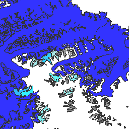
var dataset = ee.FeatureCollection('GLIMS/current');\nvar visParams = {\n palette: ['gray', 'cyan', 'blue'],\n min: 0.0,\n max: 10.0,\n opacity: 0.8,\n};\nvar image = ee.Image().float().paint(dataset, 'area');\nMap.setCenter(-35.618, 66.743, 7);\nMap.addLayer(image, visParams, 'GLIMS/current');\nMap.addLayer(dataset, null, 'for Inspector', false);\n```\n[Open in Code Editor](https://code.earthengine.google.com/?scriptPath=Examples:Datasets/GLIMS/GLIMS_current)\n\n### Visualize as a FeatureView\n\n\nA `FeatureView` is a view-only, accelerated representation of a\n`FeatureCollection`. For more details, visit the\n[`FeatureView` documentation.](/earth-engine/guides/featureview_overview)\n| **Important:** Earth Engine is a platform for petabyte-scale scientific analysis and visualization of geospatial datasets, both for public benefit and for business and government users. Earth Engine is free to use for research, education, and nonprofit use. To get started, please [register for Earth Engine access.](https://console.cloud.google.com/earth-engine)\n\n### Code Editor (JavaScript)\n\n```javascript\nvar fvLayer = ui.Map.FeatureViewLayer('GLIMS/current_FeatureView');\n\nvar visParams = {\n color: {\n property: 'area',\n mode: 'linear',\n palette: ['gray', 'cyan', 'blue'],\n min: 0.0,\n max: 10.0\n },\n opacity: 0.8,\n polygonStrokeOpacity: 0\n};\n\nfvLayer.setVisParams(visParams);\nfvLayer.setName('GLIMS/current');\n\nMap.setCenter(-35.618, 66.743, 7);\nMap.add(fvLayer);\n```\n[Open in Code Editor](https://code.earthengine.google.com/?scriptPath=Examples:Datasets/GLIMS/GLIMS_current_FeatureView) \n[GLIMS Current: Global Land Ice Measurements From Space](/earth-engine/datasets/catalog/GLIMS_current) \nGlobal Land Ice Measurements from Space (GLIMS) is an international initiative with the goal of repeatedly surveying the world's estimated 200,000 glaciers. The project seeks to create a globally comprehensive inventory of land ice, including measurements of glacier area, geometry, surface velocity, and snow line elevation. To perform these analyses, ... \nGLIMS/current, cryosphere,glacier,glims,ice,landcover,nasa,nsidc,snow,table \n1750-01-01T00:00:00Z/2023-06-07T00:00:00Z \n-90 -180 90 180 \nGoogle Earth Engine \nhttps://developers.google.com/earth-engine/datasets\n\n- [https://doi.org/10.7265/N5V98602](https://doi.org/https://www.glims.org)\n- [https://doi.org/10.7265/N5V98602](https://doi.org/https://developers.google.com/earth-engine/datasets/catalog/GLIMS_current)"]]