- در دسترس بودن مجموعه دادهها
- 1999-01-01T00:00:00Z–2020-01-01T00:00:00Z
- تولیدکننده مجموعه داده
- گوگل
- برچسبها
توضیحات
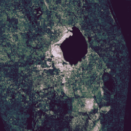
این مجموعه شامل نتایج از پیش محاسبهشده از اجرای الگوریتم تشخیص و طبقهبندی تغییرات پیوسته (CCDC) بر روی دادههای بازتاب سطحی لندست به مدت 20 سال است. CCDC یک الگوریتم یافتن نقطه شکست است که از برازش هارمونیک با آستانه RMSE پویا برای تشخیص نقاط شکست در دادههای سری زمانی استفاده میکند.
این مجموعه داده از سری زمانی بازتاب سطحی Tier-1، مجموعه لندست 5، 7 و 8، با استفاده از تمام تصاویر روز بین 1999-01-01 و 2019-12-31 ایجاد شده است. هر تصویر برای پوشاندن پیکسلهایی که به عنوان ابر، سایه یا برف (مطابق با باند 'pixel_qa')، پیکسلهای اشباع شده و پیکسلهایی با کدورت جوی > 300 (مطابق با باندهای 'sr_atmos_opacity' و 'sr_aerosol' مشخص میشوند) شناسایی شدهاند، پیشپردازش شد. پیکسلهایی که در همپوشانی صحنه شمال/جنوب تکرار شدهاند، حذف شدند. نتایج برای تمام خشکیهای بین عرض جغرافیایی -60° و +85° به صورت کاشیهای 2 درجهای خروجی داده شدند. تصاویر برای تبدیل ساده به یک تصویر سراسری با استفاده از تابع موزاییک () مناسب هستند.
الگوریتم CCDC با پارامترهای پیشفرض الگوریتم به جز dateFormat اجرا شد:
- tmaskBands: ['green', 'swir']
- حداقل مشاهدات: ۶
- احتمال کایاسکوئر: ۰.۹۹
- مقیاس حداقل تعداد سال: ۱.۳۳
- قالب تاریخ: ۱ (سال کسری)
- لامبدا: ۲۰
- حداکثر تعداد تکرار: ۲۵۰۰۰
هر پیکسل در خروجی با استفاده از آرایههای با طول متغیر کدگذاری میشود. طول بیرونی هر آرایه (محور 0) مربوط به تعداد نقاط شکست یافت شده در آن مکان است. باندهای coefs شامل آرایههای دوبعدی هستند که در آن هر آرایه داخلی شامل ضرایب مقیاسبندی برای 8 عبارت در مدل هارمونیک خطی به ترتیب زیر است: [offset, t, cos(ωt), sin(ωt), cos(2ωt), sin(2ωt), cos(3ωt), sin(3ωt)]، که در آن ω = 2Π. مدلها برای تولید واحدهای بازتاب (0.0 - 1.0) برای باندهای نوری و درجه (K) / 100.0 برای باند حرارتی مقیاسبندی میشوند.
توجه داشته باشید که از آنجایی که باندهای خروجی آرایهای هستند و فقط با استفاده از سیاست هرمی SAMPLE میتوان آنها را کوچکنمایی کرد، در سطوح بزرگنمایی پایینتر، نتایج معمولاً دیگر نمایانگر دادههای با وضوح کامل نیستند و برای مثال، مرزهای کاشیها به دلیل ماسکهای کوچکنمایی شده قابل مشاهده هستند. بنابراین استفاده از این مجموعه داده در وضوحهای کمتر از ۲۴۰ متر بر پیکسل توصیه نمیشود.
در حال حاضر هیچ برنامهای برای اضافه کردن داراییهای پس از سال ۲۰۱۹ به این مجموعه دادهها وجود ندارد.
باندها
اندازه پیکسل
۳۰ متر
باندها
| نام | اندازه پیکسل | توضیحات |
|---|---|---|
tStart | متر | آرایه تکبعدی شامل تاریخ شروع هر بخش (سال کسری). |
tEnd | متر | آرایه تکبعدی شامل تاریخ پایان هر بخش (سال کسری). |
tBreak | متر | آرایه تکبعدی شامل تاریخ نقطه شکست شناساییشده در هر بخش (سال کسری). |
numObs | متر | آرایه تکبعدی شامل تعداد مشاهدات یافتشده در هر بخش. |
changeProb | متر | یک احتمال کاذب برای واقعی بودن نقطه شکست شناسایی شده. |
BLUE_coefs | متر | آرایه دوبعدی شامل ضرایب مدل هارمونیک برای باند آبی، برای هر بخش. |
GREEN_coefs | متر | آرایه دوبعدی شامل ضرایب مدل هارمونیک برای باند سبز، برای هر بخش. |
RED_coefs | متر | آرایه دوبعدی شامل ضرایب مدل هارمونیک برای باند قرمز، برای هر بخش. |
NIR_coefs | متر | آرایه دوبعدی شامل ضرایب مدل هارمونیک برای باند مادون قرمز نزدیک، برای هر بخش. |
SWIR1_coefs | متر | آرایه دوبعدی شامل ضرایب مدل هارمونیک برای باند مادون قرمز موج کوتاه (1.55μm-1.75μm)، برای هر بخش. |
SWIR2_coefs | متر | آرایه دوبعدی شامل ضرایب مدل هارمونیک برای باند مادون قرمز موج کوتاه (۲.۰۹μm-۲.۳۵μm)، برای هر بخش. |
TEMP_coefs | متر | آرایه دوبعدی شامل ضرایب مدل هارمونیک برای باند حرارتی، برای هر بخش. |
BLUE_rmse | متر | آرایه یک بعدی حاوی RMSE مدل برای باند آبی، برای هر بخش. |
GREEN_rmse | متر | آرایه یک بعدی حاوی RMSE مدل برای باند سبز، برای هر بخش. |
RED_rmse | متر | آرایه یک بعدی حاوی RMSE مدل برای باند قرمز، برای هر بخش. |
NIR_rmse | متر | آرایه یک بعدی شامل RMSE مدل برای باند مادون قرمز نزدیک، برای هر بخش. |
SWIR1_rmse | متر | آرایه یک بعدی شامل RMSE مدل برای باند مادون قرمز موج کوتاه (1.55μm-1.75μm)، برای هر بخش. |
SWIR2_rmse | متر | آرایه یک بعدی شامل RMSE مدل برای باند مادون قرمز موج کوتاه (2.09μm-2.35μm)، برای هر بخش. |
TEMP_rmse | متر | آرایه یک بعدی حاوی RMSE مدل برای باند حرارتی، برای هر بخش. |
BLUE_magnitude | متر | آرایه یک بعدی حاوی بزرگی نقطه شکست شناسایی شده برای باند آبی، برای هر بخش. |
GREEN_magnitude | متر | آرایه یک بعدی حاوی بزرگی نقطه شکست شناسایی شده برای باند سبز، برای هر بخش. |
RED_magnitude | متر | آرایه یک بعدی حاوی بزرگی نقطه شکست شناسایی شده برای باند قرمز، برای هر بخش. |
NIR_magnitude | متر | آرایه یک بعدی شامل بزرگی نقطه شکست شناسایی شده برای باند مادون قرمز نزدیک، برای هر بخش. |
SWIR1_magnitude | متر | آرایه یک بعدی حاوی بزرگی نقطه شکست شناسایی شده برای باند مادون قرمز موج کوتاه-۱ (۱.۵۵μm-۱.۷۵μm)، برای هر بخش. |
SWIR2_magnitude | متر | آرایه یک بعدی حاوی بزرگی نقطه شکست شناسایی شده برای باند مادون قرمز موج کوتاه-۲ (۲.۰۹μm-۲.۳۵μm)، برای هر بخش. |
TEMP_magnitude | متر | آرایه یک بعدی حاوی بزرگی نقطه شکست شناسایی شده برای باند حرارتی، برای هر بخش. |
شرایط استفاده
شرایط استفاده