এই বৃহৎ আকারের উন্মুক্ত ডেটাসেটে উচ্চ-রেজোলিউশন 50 সেমি স্যাটেলাইট চিত্র থেকে প্রাপ্ত ভবনগুলির রূপরেখা রয়েছে। এতে আফ্রিকা, ল্যাটিন আমেরিকা, ক্যারিবিয়ান, দক্ষিণ এশিয়া এবং দক্ষিণ-পূর্ব এশিয়ায় 1.8B বিল্ডিং সনাক্তকরণ রয়েছে। অনুমানটি 58M কিমি² এলাকা জুড়ে বিস্তৃত।
এই ডেটাসেটের প্রতিটি বিল্ডিংয়ের জন্য আমরা মাটিতে তার পায়ের ছাপ বর্ণনা করে বহুভুজ অন্তর্ভুক্ত করি, একটি আত্মবিশ্বাসের স্কোর নির্দেশ করে যে আমরা কতটা নিশ্চিত যে এটি একটি বিল্ডিং এবং একটি প্লাস কোড বিল্ডিংয়ের কেন্দ্রের সাথে সম্পর্কিত। বিল্ডিংয়ের ধরন, এর রাস্তার ঠিকানা, বা এর জ্যামিতি ব্যতীত অন্য কোনও বিবরণ সম্পর্কে কোনও তথ্য নেই।
বিল্ডিং ফুটপ্রিন্টগুলি গুরুত্বপূর্ণ অ্যাপ্লিকেশনগুলির একটি পরিসরের জন্য দরকারী: জনসংখ্যার অনুমান, নগর পরিকল্পনা এবং পরিবেশ ও জলবায়ু বিজ্ঞানের মানবিক প্রতিক্রিয়া থেকে। প্রকল্পটি ঘানায় ভিত্তিক, আফ্রিকা মহাদেশের উপর প্রাথমিক ফোকাস এবং দক্ষিণ এশিয়া, দক্ষিণ-পূর্ব এশিয়া, ল্যাটিন আমেরিকা এবং ক্যারিবিয়ানের উপর নতুন আপডেট।
2023 সালের মে মাসে অনুমান করা হয়েছিল।
আরও বিশদ বিবরণের জন্য ওপেন বিল্ডিং ডেটাসেটের অফিসিয়াল ওয়েবসাইট দেখুন।
টেবিল স্কিমা
টেবিল স্কিমা
নাম
টাইপ
বর্ণনা
এলাকা_ইন_মিটার
দ্বিগুণ
বহুভুজের বর্গ মিটার এলাকা।
আত্মবিশ্বাস
দ্বিগুণ
মডেল দ্বারা নির্ধারিত আত্মবিশ্বাস স্কোর [0.65;1.0]।
W. Sirko, S. Kashubin, M. Ritter, A. Annkah, YSE Bouchareb, Y. Dauphin, D. Keysers, M. Neumann, M. Cisse, JA Quinn. উচ্চ রেজোলিউশন স্যাটেলাইট চিত্র থেকে মহাদেশীয়-স্কেল বিল্ডিং সনাক্তকরণ। arXiv:2107.12283 , 2021।
এই বৃহৎ আকারের উন্মুক্ত ডেটাসেটে উচ্চ-রেজোলিউশন 50 সেমি স্যাটেলাইট চিত্র থেকে প্রাপ্ত ভবনগুলির রূপরেখা রয়েছে। এতে আফ্রিকা, ল্যাটিন আমেরিকা, ক্যারিবিয়ান, দক্ষিণ এশিয়া এবং দক্ষিণ-পূর্ব এশিয়ায় 1.8B বিল্ডিং সনাক্তকরণ রয়েছে। অনুমানটি 58M কিমি² এলাকা জুড়ে বিস্তৃত। এই ডেটাসেটের প্রতিটি বিল্ডিংয়ের জন্য আমরা বর্ণনাকারী বহুভুজ অন্তর্ভুক্ত করি …
[null,null,[],[[["\u003cp\u003eThe Open Buildings dataset provides outlines of 1.8B buildings derived from 50 cm satellite imagery across Africa, Latin America, Caribbean, South Asia, and Southeast Asia.\u003c/p\u003e\n"],["\u003cp\u003eIt includes building footprints, a confidence score, and a Plus Code for each building, covering an area of 58M km².\u003c/p\u003e\n"],["\u003cp\u003eBuilding footprints can be used for various applications, including population estimation, urban planning, and environmental science.\u003c/p\u003e\n"],["\u003cp\u003eThe dataset is available under the CC-BY-4.0 license and is accessible through Google Earth Engine.\u003c/p\u003e\n"],["\u003cp\u003eThe dataset includes building confidence scores, allowing users to filter buildings based on the model's certainty.\u003c/p\u003e\n"]]],[],null,["# Open Buildings V3 Polygons\n\nDataset Availability\n: 2023-05-30T00:00:00Z--2023-05-30T00:00:00Z\n\nDataset Provider\n:\n\n\n [Google Research - Open Buildings](https://sites.research.google/open-buildings/)\n\nTags\n:\n [africa](/earth-engine/datasets/tags/africa) [asia](/earth-engine/datasets/tags/asia) [building](/earth-engine/datasets/tags/building) [built-up](/earth-engine/datasets/tags/built-up) [open-buildings](/earth-engine/datasets/tags/open-buildings) [population](/earth-engine/datasets/tags/population) [south-asia](/earth-engine/datasets/tags/south-asia) [southeast-asia](/earth-engine/datasets/tags/southeast-asia) [table](/earth-engine/datasets/tags/table) \nstructure \n\n#### Description\n\nThis large-scale open dataset consists of outlines of buildings derived\nfrom high-resolution 50 cm satellite imagery. It contains 1.8B building\ndetections in Africa, Latin America, Caribbean, South Asia and Southeast\nAsia. The inference spanned an area of 58M km².\n\nFor each building in this dataset we include the polygon describing its\nfootprint on the ground, a confidence score indicating how sure we are that\nthis is a building, and a [Plus Code](https://plus.codes/) corresponding to\nthe center of the building. There is no information about the type of\nbuilding, its street address, or any details other than its geometry.\n\nBuilding footprints are useful for a range of important applications: from\npopulation estimation, urban planning and humanitarian response to\nenvironmental and climate science. The project is based in Ghana, with an\ninitial focus on the continent of Africa and new updates on South Asia,\nSouth-East Asia, Latin America and the Caribbean.\n\nInference was carried out during May 2023.\n\nFor more details see the official\n[website](https://sites.research.google/open-buildings/) of the Open\nBuildings dataset.\n\n### Table Schema\n\n**Table Schema**\n\n| Name | Type | Description |\n|--------------------|----------|-----------------------------------------------------------------------------|\n| area_in_meters | DOUBLE | Area in square meters of the polygon. |\n| confidence | DOUBLE | Confidence score \\[0.65;1.0\\] assigned by the model. |\n| full_plus_code | STRING | The full [Plus Code](https://plus.codes/) at the building polygon centroid. |\n| longitude_latitude | GEOMETRY | Centroid of the polygon. |\n\n### Terms of Use\n\n**Terms of Use**\n\n[CC-BY-4.0](https://spdx.org/licenses/CC-BY-4.0.html)\n\n### Citations\n\nCitations:\n\n- W. Sirko, S. Kashubin, M. Ritter, A. Annkah, Y.S.E. Bouchareb, Y. Dauphin,\n D. Keysers, M. Neumann, M. Cisse, J.A. Quinn. Continental-scale building\n detection from high resolution satellite imagery.\n [arXiv:2107.12283](https://arxiv.org/abs/2107.12283), 2021.\n\n### Explore with Earth Engine\n\n| **Important:** Earth Engine is a platform for petabyte-scale scientific analysis and visualization of geospatial datasets, both for public benefit and for business and government users. Earth Engine is free to use for research, education, and nonprofit use. To get started, please [register for Earth Engine access.](https://console.cloud.google.com/earth-engine)\n\n### Code Editor (JavaScript)\n\n```javascript\n
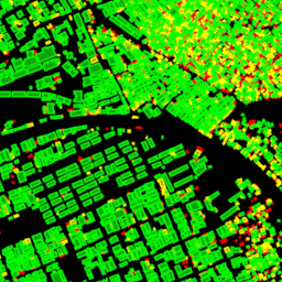
// Visualization of GOOGLE/Research/open-buildings/v3/polygons.\n\nvar t = ee.FeatureCollection('GOOGLE/Research/open-buildings/v3/polygons');\n\nvar t_065_070 = t.filter('confidence \u003e= 0.65 && confidence \u003c 0.7');\nvar t_070_075 = t.filter('confidence \u003e= 0.7 && confidence \u003c 0.75');\nvar t_gte_075 = t.filter('confidence \u003e= 0.75');\n\nMap.addLayer(t_065_070, {color: 'FF0000'}, 'Buildings confidence [0.65; 0.7)');\nMap.addLayer(t_070_075, {color: 'FFFF00'}, 'Buildings confidence [0.7; 0.75)');\nMap.addLayer(t_gte_075, {color: '00FF00'}, 'Buildings confidence \u003e= 0.75');\nMap.setCenter(3.389, 6.492, 17); // Lagos, Nigeria\nMap.setOptions('SATELLITE');\n```\n[Open in Code Editor](https://code.earthengine.google.com/?scriptPath=Examples:Datasets/GOOGLE/GOOGLE_Research_open-buildings_v3_polygons)\n\n### Visualize as a FeatureView\n\n\nA `FeatureView` is a view-only, accelerated representation of a\n`FeatureCollection`. For more details, visit the\n[`FeatureView` documentation.](/earth-engine/guides/featureview_overview)\n| **Important:** Earth Engine is a platform for petabyte-scale scientific analysis and visualization of geospatial datasets, both for public benefit and for business and government users. Earth Engine is free to use for research, education, and nonprofit use. To get started, please [register for Earth Engine access.](https://console.cloud.google.com/earth-engine)\n\n### Code Editor (JavaScript)\n\n```javascript\nvar fvLayer = ui.Map.FeatureViewLayer(\n 'GOOGLE/Research/open-buildings/v3/polygons_FeatureView');\n\nvar visParams = {\n rules: [\n {\n filter: ee.Filter.expression('confidence \u003e= 0.65 && confidence \u003c 0.7'),\n color: 'FF0000'\n },\n {\n filter: ee.Filter.expression('confidence \u003e= 0.7 && confidence \u003c 0.75'),\n color: 'FFFF00'\n },\n {\n filter: ee.Filter.expression('confidence \u003e= 0.75'),\n color: '00FF00'\n },\n ]\n};\n\nfvLayer.setVisParams(visParams);\nfvLayer.setName('Buildings');\n\nMap.setCenter(3.389, 6.492, 17); // Lagos, Nigeria\nMap.add(fvLayer);\nMap.setOptions('SATELLITE');\n```\n[Open in Code Editor](https://code.earthengine.google.com/?scriptPath=Examples:Datasets/GOOGLE/GOOGLE_Research_open-buildings_v3_polygons_FeatureView) \n[Open Buildings V3 Polygons](/earth-engine/datasets/catalog/GOOGLE_Research_open-buildings_v3_polygons) \nThis large-scale open dataset consists of outlines of buildings derived from high-resolution 50 cm satellite imagery. It contains 1.8B building detections in Africa, Latin America, Caribbean, South Asia and Southeast Asia. The inference spanned an area of 58M km². For each building in this dataset we include the polygon describing ... \nGOOGLE/Research/open-buildings/v3/polygons, africa,asia,building,built-up,open-buildings,population,south-asia,southeast-asia,table \n2023-05-30T00:00:00Z/2023-05-30T00:00:00Z \n-90 -180 90 180 \nGoogle Earth Engine \nhttps://developers.google.com/earth-engine/datasets\n\n- [](https://doi.org/https://sites.research.google/open-buildings/)\n- [](https://doi.org/https://developers.google.com/earth-engine/datasets/catalog/GOOGLE_Research_open-buildings_v3_polygons)"]]