- 데이터 세트 제공
- 2022-09-26T00:00:00Z–2024-01-08T00:00:00Z
- 데이터 세트 출처
- JAXA EORC
- 태그
설명
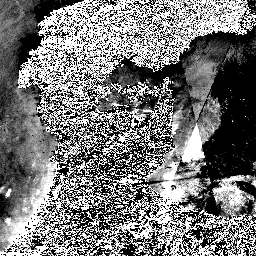
2024년 1월 1일 밤부터 일본 부처 및 관련 기관의 요청에 따라 JAXA는 ALOS-2 PALSAR-2 긴급 관측을 시행했습니다. JAXA는 이러한 긴급 관측 데이터가 재해 관리에 매우 유용할 것으로 예상되므로 Google Earth Engine에서 이러한 데이터를 공개하여 공공 및 연구 용도로 사용할 수 있도록 결정했습니다.
JAXA는 2024년 1월 1~3일 및 1월 8일의 3m 단일 편파를 사용한 PALSAR-2 레벨 2.1 스트립 지도 모드 관측 데이터를 일부 보관 데이터와 함께 출시했습니다. PALSAR-2 레벨 2.1 데이터는 디지털 고도 모델을 사용하여 레벨 1.1 데이터에서 직교 보정됩니다. DN 값은 다음 방정식을 사용하여 데시벨 단위 (dB)의 시그마 제로 값으로 변환할 수 있습니다.
- σ0 = 10*log10(DN2) - 83.0 dB
아래는 데이터 세트에 데이터가 있는 날짜입니다.
| 관측 날짜 | 프레임 | Beam | A/D |
|---|---|---|---|
| 2024년 1월 1일 및 2022년 9월 26일 | 0750, 0760, 0770 | U2-6L | 오름차순 |
| 2024년 1월 2일 및 2023년 6월 6일 | 2820, 2830, 2840 | U2-8L | 내림차순 |
| 2024년 1월 8일, 2024년 1월 3일, 2023년 12월 6일 | 0720, 0730 | U2-9R | 오름차순 |
대역
대역
픽셀 크기: 3미터 (모든 밴드)
| 이름 | 픽셀 크기 | 설명 |
|---|---|---|
b1 |
3미터 | HH 편광 지형 평탄화 감마 제로 후방산란 계수입니다. |
이용약관
이용약관
누구나 비상업적 용도로만 이 데이터를 무료로 사용할 수 있습니다. 자세한 이용약관은 JAXA G-Portal 서비스 약관(7항)을 참고하세요. G-Portal 데이터에 관한 조건입니다.
인용
인용:
이 논문에 사용된 데이터는 일본 항공우주탐사국 (JAXA)의 지구 관측 연구 센터 (EORC)에서 제공했습니다.
Earth Engine으로 탐색
코드 편집기(JavaScript)
var coll = ee.ImageCollection('JAXA/ALOS/PALSAR-2/Level2_1/StripMap_202401');

var vis = {min: 0, max: 8000};

// Visualize different date ranges
var visualizeDateRange = function(startDate, endDate, layerName) {
  var dateRange = coll.filterDate(startDate, endDate);
  Map.addLayer(dateRange, vis, layerName);
};

visualizeDateRange('2023-06-06', '2023-06-07', 'Before-2023-06-06');
visualizeDateRange('2023-06-12', '2023-06-13', 'Before-2023-06-12');
visualizeDateRange('2022-09-26', '2022-09-27', 'Before-2022-09-26');
visualizeDateRange('2023-12-06', '2023-12-07', 'Before-2023-12-06');
visualizeDateRange('2024-01-01', '2024-01-02', 'After-2024-01-01');
visualizeDateRange('2024-01-02', '2024-01-03', 'After-2024-01-02');
visualizeDateRange('2024-01-03', '2024-01-04', 'After-2024-01-03');
visualizeDateRange('2024-01-08', '2024-01-09', 'After-2024-01-08');

Map.setCenter(137.2228, 37.1204, 8);