-
ALOS-2 PALSAR-2 StripMap Level 2.1
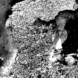
2024년 1월 1일 밤부터 일본 부처 및 관련 기관의 요청에 따라 JAXA는 ALOS-2 PALSAR-2 긴급 관측을 시행했습니다. JAXA는 이러한 긴급 관측 데이터가 재해 관리에 매우 유용할 것으로 예상되므로 …에 이러한 데이터를 공개하기로 결정했습니다. alos2 eroc jaxa palsar2 레이더 sar -
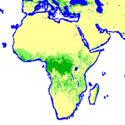
전역 3등급 PALSAR-2/PALSAR 산림/비산림 지도
2017~2020년의 4개 클래스가 포함된 이 데이터 세트의 최신 버전은 JAXA/ALOS/PALSAR/YEARLY/FNF4에서 확인할 수 있습니다. 전 세계 산림/비산림 지도 (FNF)는 전 세계 25m 해상도 PALSAR-2/PALSAR SAR 모자이크에서 SAR 이미지 (후방 산란 계수)를 분류하여 생성되므로 강한 후방 산란 픽셀은 … alos alos2 classification eroc forest forest-biomass -
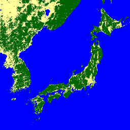
전역 4등급 PALSAR-2/PALSAR 산림/비산림 지도
전 세계 산림/비산림 지도 (FNF)는 전 세계 25m 해상도 PALSAR-2/PALSAR SAR 모자이크에서 SAR 이미지 (후방 산란 계수)를 분류하여 생성되며, 강한 후방 산란 픽셀과 약한 후방 산란 픽셀이 각각 '산림'과 '비산림'으로 할당됩니다. 여기서 '숲'은 …이 있는 자연 숲으로 정의됩니다. alos alos2 classification eroc forest forest-biomass -
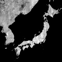
Global PALSAR-2/PALSAR Yearly Mosaic, version 1(전역 PALSAR-2/PALSAR 연간 모자이크, 버전 1)

2015~2021년 데이터가 포함된 최신 버전의 데이터 세트는 JAXA/ALOS/PALSAR/YEARLY/SAR_EPOCH에서 확인할 수 있습니다. 전역 25m PALSAR/PALSAR-2 모자이크는 PALSAR/PALSAR-2의 SAR 이미지 스트립을 모자이크하여 만든 연속적인 전역 SAR 이미지입니다. 각 연도 및 위치에 대해 스트립 데이터는 … alos alos2 eroc jaxa palsar palsar2 -
Global PALSAR-2/PALSAR Yearly Mosaic, version 2.5.0
전 세계 25m PALSAR/PALSAR-2 모자이크는 PALSAR/PALSAR-2의 SAR 이미지 스트립을 모자이크하여 만든 연속적인 전 세계 SAR 이미지입니다. 각 연도와 위치에 대해 해당 기간에 제공되는 탐색 모자이크를 시각적으로 검사하여 스트립 데이터를 선택했으며, 최소한의 … alos alos2 eroc jaxa palsar palsar2 -
Global Seasonal Sentinel-1 Interferometric Coherence and Backscatter V2019 Backscatter(전 세계 계절별 Sentinel-1 간섭계 일관성 및 후방산란 V2019 후방산란)

이 데이터 세트는 다계절, 전 세계 C-밴드 합성 개구 레이더(SAR) 간섭계 반복 통과 일관성 및 후방산란 특징의 최초 공간 표현입니다. 커버리지는 북위 82도에서 남위 79도까지의 육지와 빙상으로 구성됩니다. 이 데이터 세트는 2019년 12월 1일부터 2020년 11월 30일까지 광대역 간섭계… 후방 산란 지구 빅데이터 jpl nasa 편광 레이더 -
Global Seasonal Sentinel-1 Interferometric Coherence and Backscatter V2019 Coherence

이 데이터 세트는 다계절, 전 세계 C-밴드 합성 개구 레이더(SAR) 간섭계 반복 통과 일관성 및 후방산란 특징의 최초 공간 표현입니다. 커버리지는 북위 82도에서 남위 79도까지의 육지와 빙상으로 구성됩니다. 이 데이터 세트는 2019년 12월 1일부터 2020년 11월 30일까지 광대역 간섭계… earth-big-data jpl nasa 편광 레이더 sar -
Global Seasonal Sentinel-1 Interferometric Coherence and Backscatter V2019 Decay Model Parameters(전 세계 계절별 Sentinel-1 간섭계 일관성 및 후방산란 V2019 감쇠 모델 파라미터)

이 데이터 세트는 다계절, 전 세계 C-밴드 합성 개구 레이더(SAR) 간섭계 반복 통과 일관성 및 후방산란 특징의 최초 공간 표현입니다. 커버리지는 북위 82도에서 남위 79도까지의 육지와 빙상으로 구성됩니다. 이 데이터 세트는 2019년 12월 1일부터 2020년 11월 30일까지 광대역 간섭계… earth-big-data jpl nasa 편광 레이더 sar -
Global Seasonal Sentinel-1 Interferometric Coherence and Backscatter V2019 Incidence Layover Shadow(전 세계 계절별 Sentinel-1 간섭계 일관성 및 후방산란 V2019 입사각 오버레이 그림자)

이 데이터 세트는 다계절, 전 세계 C-밴드 합성 개구 레이더(SAR) 간섭계 반복 통과 일관성 및 후방산란 특징의 최초 공간 표현입니다. 커버리지는 북위 82도에서 남위 79도까지의 육지와 빙상으로 구성됩니다. 이 데이터 세트는 2019년 12월 1일부터 2020년 11월 30일까지 광대역 간섭계… earth-big-data jpl nasa 편광 레이더 sar -
Sentinel-1 정적 레이어 V1.0의 OPERA 방사량으로 지형 보정된 SAR 후방산란

이 제품에는 Sentinel-1 데이터 세트의 OPERA 방사량으로 지형 보정된 SAR 후방산란과 연결된 정적 레이더 형상 레이어가 포함되어 있습니다. S1 미션의 좁은 궤도 튜브로 인해 입사각, 지역 입사각, 룩 수, RTC 영역 정규화 요소 (ANF)와 같은 레이더 형상 레이어는 … jpl nasa opera sar 위성 이미지 sentinel1 파생 -
Sentinel-1의 OPERA 방사량으로 지형 보정된 SAR 후방산란 V1.0

이 제품은 지형에 대해 정규화된 레이더 후방산란으로 구성됩니다. 표면 거칠기, 토양 수분, 식물과 같은 지상 산란 물체의 물리적 속성과 관련된 신호를 매핑합니다. OPERA RTC-S1 제품은 Copernicus Sentinel-1 Interferometric Wide (IW) … 후방 산란 jpl nasa opera 편광 레이더 -
PALSAR-2 ScanSAR 레벨 2.2

25m PALSAR-2 ScanSAR는 관측 폭이 350km인 PALSAR-2 광역 관측 모드의 정규화된 후방 산란 데이터입니다. SAR 이미지는 ALOS World 3D - 30m (AW3D30) 디지털 지표면 모델을 사용하여 직교 보정되고 경사 보정되었습니다. 편광 데이터는 …에 저장됩니다. alos2 eroc jaxa palsar2 레이더 sar -
Sentinel-1 SAR GRD: C-밴드 합성 개구 레이더 지상 범위 감지, 로그 스케일링

Sentinel-1 미션은 5.405GHz (C 대역)의 이중 편파 C 대역 합성 개구 레이더 (SAR) 기기에서 데이터를 제공합니다. 이 컬렉션에는 Sentinel-1 Toolbox를 사용하여 보정되고 직교 보정된 제품을 생성하도록 처리된 S1 지상 범위 감지 (GRD) 장면이 포함되어 있습니다. 컬렉션은 매일 업데이트됩니다. 새로운 기능 후방 산란 copernicus esa eu 편광 레이더
Datasets tagged sar in Earth Engine
[null,null,[],[],[]]