グローバル 25m PALSAR/PALSAR-2 モザイクは、PALSAR/PALSAR-2 の SAR 画像のストリップをモザイク処理して作成されたシームレスなグローバル SAR 画像です。各年と場所について、期間中に利用可能なブラウズ モザイクの目視検査によってストリップ データが選択され、地表水分に対する応答が最小限のものが優先的に使用されました。利用可能なデータが限られていた場合(特定の緊急事態の観測が必要な場合など)、2006 年を含め、前年または翌年のデータが選択されました。Shimada et al. 2014
SAR 画像は、90 m の SRTM デジタル標高モデルを使用してオルソ補正と傾斜補正が行われました。ストライプ除去プロセス(Shimada & Isoguchi, 2002, 2010)を適用して、隣接するストライプ間の強度差を均等化しました。この強度差は、主に地表の水分条件の季節的および日々の違いによって発生します。
[null,null,[],[[["\u003cp\u003eThe JAXA/ALOS/PALSAR/YEARLY/SAR dataset provides a global 25m resolution mosaic of PALSAR/PALSAR-2 SAR imagery from 2007-2020, excluding 2011-2014.\u003c/p\u003e\n"],["\u003cp\u003eThe dataset includes HH and HV polarization backscattering coefficients, local incidence angle, observation date, and processing information bands.\u003c/p\u003e\n"],["\u003cp\u003eImagery was orthorectified, slope corrected, and destriped to minimize intensity differences between neighboring strips.\u003c/p\u003e\n"],["\u003cp\u003eDN values can be converted to gamma naught values (dB) using the equation: γ₀ = 10log₁₀(DN²) - 83.0 dB.\u003c/p\u003e\n"],["\u003cp\u003eBackscatter values may vary over high latitude forests due to seasonal changes in tree freezing.\u003c/p\u003e\n"]]],[],null,["# Global PALSAR-2/PALSAR Yearly Mosaic, version 1\n\nDataset Availability\n: 2007-01-01T00:00:00Z--2020-01-01T00:00:00Z\n\nDataset Provider\n:\n\n\n [JAXA EORC](https://www.eorc.jaxa.jp/ALOS/en/dataset/fnf_e.htm)\n\nTags\n:\n[alos](/earth-engine/datasets/tags/alos) [alos2](/earth-engine/datasets/tags/alos2) [eroc](/earth-engine/datasets/tags/eroc) [jaxa](/earth-engine/datasets/tags/jaxa) [palsar](/earth-engine/datasets/tags/palsar) [palsar2](/earth-engine/datasets/tags/palsar2) [sar](/earth-engine/datasets/tags/sar) [satellite-imagery](/earth-engine/datasets/tags/satellite-imagery) \n\n#### Description\n\nA newer version of this dataset with data for 2015-2021 can be found in\n[JAXA/ALOS/PALSAR/YEARLY/SAR_EPOCH](/earth-engine/datasets/catalog/JAXA_ALOS_PALSAR_YEARLY_SAR_EPOCH)\n\nThe global 25m PALSAR/PALSAR-2 mosaic is a seamless global\nSAR image created by mosaicking strips of SAR imagery\nfrom PALSAR/PALSAR-2. For each year and location,\nthe strip data were selected through visual inspection of the\nbrowse mosaics available over the period, with those showing minimum\nresponse to surface moisture preferentially used. In cases\nwhere the availability was limited (e.g., because of the requirement\nfor observations during specific emergencies), data were necessarily\nselected from the year before or after, including from 2006.\n[Shimada et al. 2014](https://doi.org/10.1016/j.rse.2014.04.014)\n\nThere is no data for 2011-2014 due to the gap between ALOS and ALOS-2\ntemporal coverage.\n\nThe SAR imagery was ortho-rectificatied and slope corrected\nusing the 90m SRTM Digital Elevation Model.\nA destriping process (Shimada \\& Isoguchi, 2002, 2010) was applied\nto equalize the intensity differences between neighboring strips,\noccurring largely due to seasonal and daily differences\nin surface moisture conditions.\n\nPolarization data are stored as 16-bit digital numbers (DN).\nThe DN values can be converted to gamma naught values\nin decibel unit (dB) using the following equation:\n\n- γ₀ = 10log₁₀(DN²) - 83.0 dB\n\nAttention:\n\n- Backscatter values may vary significantly from path to path over high latitude forest areas. This is due to the change of backscattering intensity caused by freezing trees in winter.\n\nMore information is available in the provider's\n[Dataset Description](https://www.eorc.jaxa.jp/ALOS/en/palsar_fnf/DatasetDescription_PALSAR2_Mosaic_FNF_revH.pdf).\n\n### Bands\n\n\n**Pixel Size**\n\n25 meters\n\n**Bands**\n\n| Name | Units | Pixel Size | Description |\n|---------|-------|------------|--------------------------------------------------------|\n| `HH` | | meters | HH polarization backscattering coefficient, 16-bit DN. |\n| `HV` | | meters | HV polarization backscattering coefficient, 16-bit DN. |\n| `angle` | deg | meters | Local incidence angle. |\n| `date` | | meters | Observation date (days since Jan 1, 1970). |\n| `qa` | | meters | Processing information. |\n\n**qa Class Table**\n\n| Value | Color | Description |\n|-------|---------|-----------------|\n| 0 | #000000 | No data |\n| 50 | #0000ff | Ocean and water |\n| 100 | #aaaa00 | Radar layover |\n| 150 | #005555 | Radar shadowing |\n| 255 | #aa9988 | Land |\n\n### Terms of Use\n\n**Terms of Use**\n\nJAXA retains ownership of the dataset and cannot guarantee\nany problem caused by or possibly caused by using the datasets.\nAnyone wishing to publish any results using the datasets should\nclearly acknowledge the ownership of the data in the publication.\n\n### Citations\n\nCitations:\n\n- Masanobu Shimada, Takuya Itoh, Takeshi Motooka, Manabu Watanabe,\n Shiraishi Tomohiro, Rajesh Thapa, and Richard Lucas, \"New Global\n Forest/Non-forest Maps from ALOS PALSAR Data (2007-2010)\", Remote Sensing\n of Environment, 155, pp. 13-31, December 2014.\n [doi:10.1016/j.rse.2014.04.014.](https://doi.org/10.1016/j.rse.2014.04.014)\n\n### Explore with Earth Engine\n\n| **Important:** Earth Engine is a platform for petabyte-scale scientific analysis and visualization of geospatial datasets, both for public benefit and for business and government users. Earth Engine is free to use for research, education, and nonprofit use. To get started, please [register for Earth Engine access.](https://console.cloud.google.com/earth-engine)\n\n### Code Editor (JavaScript)\n\n```javascript\n
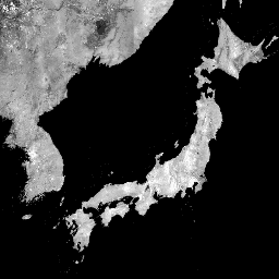
var dataset = ee.ImageCollection('JAXA/ALOS/PALSAR/YEARLY/SAR')\n .filter(ee.Filter.date('2017-01-01', '2018-01-01'));\nvar sarHh = dataset.select('HH');\nvar sarHhVis = {\n min: 0.0,\n max: 10000.0,\n};\nMap.setCenter(136.85, 37.37, 4);\nMap.addLayer(sarHh, sarHhVis, 'SAR HH');\n```\n[Open in Code Editor](https://code.earthengine.google.com/?scriptPath=Examples:Datasets/JAXA/JAXA_ALOS_PALSAR_YEARLY_SAR) \n[Global PALSAR-2/PALSAR Yearly Mosaic, version 1](/earth-engine/datasets/catalog/JAXA_ALOS_PALSAR_YEARLY_SAR) \nA newer version of this dataset with data for 2015-2021 can be found in JAXA/ALOS/PALSAR/YEARLY/SAR_EPOCH The global 25m PALSAR/PALSAR-2 mosaic is a seamless global SAR image created by mosaicking strips of SAR imagery from PALSAR/PALSAR-2. For each year and location, the strip data were selected through visual inspection of the ... \nJAXA/ALOS/PALSAR/YEARLY/SAR, alos,alos2,eroc,jaxa,palsar,palsar2,sar,satellite-imagery \n2007-01-01T00:00:00Z/2020-01-01T00:00:00Z \n-90 -180 90 180 \nGoogle Earth Engine \nhttps://developers.google.com/earth-engine/datasets\n\n- [](https://doi.org/https://www.eorc.jaxa.jp/ALOS/en/dataset/fnf_e.htm)\n- [](https://doi.org/https://developers.google.com/earth-engine/datasets/catalog/JAXA_ALOS_PALSAR_YEARLY_SAR)"]]