- Disponibilidad del conjunto de datos
- 2015-01-01T00:00:00Z–2024-01-01T00:00:00Z
- Proveedor del conjunto de datos
- JAXA EORC
- Etiquetas
Descripción
El mosaico global de 25 m de PALSAR/PALSAR-2 es una imagen SAR global sin interrupciones creada a partir de mosaicos de bandas de imágenes SAR de PALSAR/PALSAR-2. Para cada año y ubicación, los datos de las tiras se seleccionaron a través de la inspección visual de los mosaicos de exploración disponibles durante el período, y se utilizaron preferentemente aquellos que mostraban una respuesta mínima a la humedad de la superficie. Solo se usaron datos del año objetivo para cada mosaico anual, por lo que no se completaron los huecos con datos de años anteriores en caso de que hubiera huecos en la cobertura global anual.
No hay datos disponibles para el período 2011-2014 debido a la brecha entre la cobertura temporal de ALOS y ALOS-2.
Las imágenes de SAR se ortorrectificaron y se corrigieron según la pendiente con el modelo digital de superficie ALOS World 3D - 30m (AW3D30).
Se aplicó un proceso de eliminación de bandas (Shimada & Isoguchi, 2002, 2010) para igualar las diferencias de intensidad entre las bandas vecinas, que se producen principalmente debido a las diferencias estacionales y diarias en las condiciones de humedad de la superficie.
Los datos de polarización se almacenan como números digitales (DN) de 16 bits. Los valores de DN se pueden convertir en valores de gamma naught en unidades de decibelios (dB) con la siguiente ecuación:
- γ₀ = 10log₁₀(DN²) - 83.0 dB
Atención:
- Los valores de dispersión retroactiva pueden variar significativamente de una ruta a otra en las áreas forestales de latitudes altas. Esto se debe al cambio en la intensidad de la retrodispersión causado por los árboles congelados en invierno.
Puedes encontrar más información en la Descripción del conjunto de datos del proveedor.
Bandas
Tamaño de los píxeles
25 metros
Bandas
| Nombre | Unidades | Tamaño de los píxeles | Descripción |
|---|---|---|---|
HH |
metros | Coeficiente de retrodispersión de polarización HH, DN de 16 bits. |
|
HV |
metros | Coeficiente de retrodispersión de polarización HV, DN de 16 bits. |
|
angle |
º | metros | Ángulo de incidencia local. |
epoch |
metros | Es la marca de tiempo de la fecha de observación (milisegundos desde el 1 de enero de 1970). Esta banda se calcula sobre la marcha a partir de la banda "fecha" de los datos sin procesar, que representa la diferencia en días entre el 24/05/2014 y la fecha de observación. |
|
qa |
metros | Procesa información. |
Tabla de la clase qa
| Valor | Color | Descripción |
|---|---|---|
| 0 | #000000 | No hay datos |
| 50 | #0000ff | Océano y agua |
| 100 | #aaaa00 | Radar layover |
| 150 | #005555 | Obstrucción del radar |
| 255 | #aa9988 | Tierra |
Condiciones de Uso
Condiciones de Uso
JAXA conserva la propiedad del conjunto de datos y no puede garantizar ningún problema causado o posiblemente causado por el uso de los conjuntos de datos. Cualquier persona que desee publicar resultados con los conjuntos de datos debe reconocer claramente la propiedad de los datos en la publicación.
Citas
Masanobu Shimada, Takuya Itoh, Takeshi Motooka, Manabu Watanabe, Shiraishi Tomohiro, Rajesh Thapa y Richard Lucas, "New Global Forest/Non-forest Maps from ALOS PALSAR Data (2007-2010)", Remote Sensing of Environment, 155, págs. 13-31, diciembre de 2014. doi:10.1016/j.rse.2014.04.014.
Explora con Earth Engine
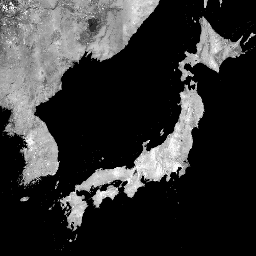
Editor de código (JavaScript)
var dataset = ee.ImageCollection('JAXA/ALOS/PALSAR/YEARLY/SAR_EPOCH')
                  .filter(ee.Filter.date('2017-01-01', '2018-01-01'));
var sarHh = dataset.select('HH');
var sarHhVis = {
  min: 0.0,
  max: 10000.0,
};
Map.setCenter(136.85, 37.37, 4);
Map.addLayer(sarHh, sarHhVis, 'SAR HH');