- Disponibilidade de conjuntos de dados
- 2018-01-01T00:00:00Z–2020-06-28T00:00:00Z
- Provedor de conjunto de dados
- Missão Global de Observação de Mudanças (GCOM, na sigla em inglês)
- Cadência
- 1 dia
- Tags
Descrição
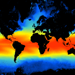
Esse produto é a temperatura da superfície do mar.
Uma versão mais recente JAXA/GCOM-C/L3/OCEAN/SST/V3 também está disponível para esse conjunto de dados, que usa esse algoritmo para processamento.
O GCOM-C realiza observações e coleta de dados globais contínuas e de longo prazo para explicar o mecanismo por trás das flutuações no orçamento de radiação e no ciclo de carbono necessárias para fazer projeções precisas sobre o aumento futuro da temperatura. Ao mesmo tempo, a cooperação com instituições de pesquisa que têm um modelo numérico climático contribui para a redução de erros na previsão do aumento da temperatura derivada do modelo numérico climático e para a melhoria da acurácia da previsão de várias mudanças ambientais. O SGLI instalado no GCOM-C é o sensor sucessor do Global Imager (GLI) instalado no ADEOS-II (MIDORI II) e é o radiômetro de imagens que mede a radiação da região do infravermelho próximo ao ultravioleta térmico (380 nm a 12 um) em 19 canais. A observação global de uma vez a cada dois dias é possível em latitudes médias perto do Japão com uma largura de observação no solo maior que 1.000 km. Além disso, o SGLI tem uma resolução maior do que o sensor global semelhante e tem uma função de observação polarizada e multiângulo.
Bandas
Tamanho do pixel
4638,3 metros
Bandas
| Nome | Unidades | Mín. | Máx. | Tamanho do pixel | Descrição | ||||||||||||||||||||||||||||||||||||||||||||||||||||||||||||||||||||||||||||||||||||||||||||||
|---|---|---|---|---|---|---|---|---|---|---|---|---|---|---|---|---|---|---|---|---|---|---|---|---|---|---|---|---|---|---|---|---|---|---|---|---|---|---|---|---|---|---|---|---|---|---|---|---|---|---|---|---|---|---|---|---|---|---|---|---|---|---|---|---|---|---|---|---|---|---|---|---|---|---|---|---|---|---|---|---|---|---|---|---|---|---|---|---|---|---|---|---|---|---|---|---|---|---|---|
SST_AVE |
°C | 0* | 65531* | metros | Temperatura da superfície do mar. |
||||||||||||||||||||||||||||||||||||||||||||||||||||||||||||||||||||||||||||||||||||||||||||||
SST_QA_flag |
metros | Controle de qualidade da SST |
|||||||||||||||||||||||||||||||||||||||||||||||||||||||||||||||||||||||||||||||||||||||||||||||||
Propriedades de imagens
Propriedades da imagem
| Nome | Tipo | Descrição |
|---|---|---|
| ALGORITHM_VERSION | STRING | Versão do algoritmo |
| GRID_INTERVAL | STRING | Resolução espacial |
| GRID_INTERVAL_UNIT | STRING | Unidade de GRID_INTERVAL |
| IMAGE_END_TIME | STRING | Horário de término da aquisição de imagens |
| IMAGE_START_TIME | STRING | Horário de início da aquisição de imagens |
| PROCESSING_RESULT | STRING | Boa, Regular, Ruim, NG |
| PROCESSING_UT | STRING | Tempo de processamento |
| PRODUCT_FILENAME | STRING | Nome do arquivo de origem |
| PRODUCT_VERSION | STRING | Versão do produto |
| SATELLITE_DIRECTION | STRING | Direção da órbita do satélite
|
| SST_AVE_OFFSET | STRING | Deslocamento |
| SST_AVE_SLOPE | STRING | Inclinação |
Termos de Uso
Termos de Uso
O uso desse conjunto de dados é sem custo financeiro e sem restrições, incluindo para fins comerciais. Qualquer pessoa que queira publicar resultados analisados ou produtos de dados de valor agregado precisa dar o crédito adequado aos dados originais do G-Portal. Por exemplo: "Dados de relações públicas da Agência Japonesa de Exploração Aeroespacial". Para produtos de dados de valor agregado, indique o crédito dos dados originais do G-Portal, por exemplo: "Os dados originais deste produto de dados de valor agregado foram fornecidos pela Agência Japonesa de Exploração Aeroespacial."
Consulte os Termos de Serviço do G-Portal (artigo 7) para mais informações.
Citações
Kurihara, Y. (outubro de 2018). ATBD para GCOM-C/SGLI Sea Surface Temperature (SST) (versão 1). Fonte: https://suzaku.eorc.jaxa.jp/GCOM_C/data/ATBD/ver1/sgli_sst_atbd.pdf
Explorar com o Earth Engine
Editor de código (JavaScript)
var dataset = ee.ImageCollection('JAXA/GCOM-C/L3/OCEAN/SST/V1')
                .filterDate('2020-01-01', '2020-02-01')
                // filter to daytime data only
                .filter(ee.Filter.eq('SATELLITE_DIRECTION', 'D'));

// Multiply with slope coefficient and add offset
var dataset = dataset.mean().multiply(0.0012).add(-10);

var vis = {
  bands: ['SST_AVE'],
  min: 0,
  max: 30,
  palette: ['000000', '005aff', '43c8c8', 'fff700', 'ff0000'],
};

Map.setCenter(128.45, 33.33, 5);

Map.addLayer(dataset, vis, 'Sea Surface Temperature');