- ডেটাসেট উপলব্ধতা
- 2018-01-01T00:00:00Z–2022-01-01T00:00:00Z
- ডেটাসেট প্রদানকারী
- যৌথ গবেষণা কেন্দ্র (JRC)
- ক্যাডেন্স
- 1 বছর
- ট্যাগ
বর্ণনা
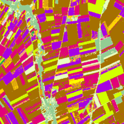
2018 সালের জন্য সেন্টিনেল-1 এবং LUCAS কোপার্নিকাস 2018 ইন-সিটু পর্যবেক্ষণের উপর ভিত্তি করে ইউরোপীয় ফসলের মানচিত্র, এবং সেন্টিনেল-1, সেন্টিনেল-2, এবং 2022-এর জন্য LUCAS কোপার্নিকাস 2022 পর্যবেক্ষণের সাথে সহায়ক ডেটার সংমিশ্রণ।
অনন্য LUCAS 2018 কোপার্নিকাস ইন-সিটু সমীক্ষার উপর ভিত্তি করে, এই ডেটাসেটটি 10m রেজোলিউশনে প্রথম EU-স্কেল ক্রপ টাইপ মানচিত্র উপস্থাপন করে, যেটি একচেটিয়াভাবে S1A এবং S1B সিন্থেটিক অ্যাপারচার রাডার পর্যবেক্ষণ থেকে নেওয়া হয়েছে। 2022 ডেটাসেট একটি মাল্টি-সোর্স পদ্ধতি ব্যবহার করে এই প্রচেষ্টা চালিয়ে যাচ্ছে যা সেন্টিনেল-1 এবং সেন্টিনেল-2 ইমেজের সাথে তাপমাত্রা এবং উচ্চতা ডেটার সাথে একত্রিত করে, যা LUCAS 2022 পর্যবেক্ষণ দ্বারা সমর্থিত।
ব্যান্ড
পিক্সেল সাইজ
10 মিটার
ব্যান্ড
| নাম | পিক্সেল সাইজ | বর্ণনা |
|---|---|---|
classification | মিটার | প্রধান ফসল-নির্দিষ্ট জমি কভার শ্রেণীবিভাগ। |
শ্রেণিবিন্যাস ক্লাস টেবিল
| মান | রঙ | বর্ণনা |
|---|---|---|
| 100 | #ff130f | কৃত্রিম |
| 211 | #a57000 | সাধারণ গম |
| 212 | #896054 | দুরুম গম |
| 213 | #e2007c | যব |
| 214 | #aa007c | রাই |
| 215 | #a05989 | ওটস |
| 216 | #ffd300 | ভুট্টা |
| 217 | #00a8e2 | ভাত |
| 218 | #d69ebc | ট্রিটিকেল |
| 219 | #d69ebc | অন্যান্য সিরিয়াল |
| 221 | #dda50a | আলু |
| 222 | #a800e2 | চিনির বীট |
| 223 | #00af49 | অন্যান্য মূল শস্য |
| 230 | #00af49 | অন্যান্য অস্থায়ী শিল্প ফসল |
| 231 | #ffff00 | সূর্যমুখী |
| 232 | #d1ff00 | রেপিসিড এবং শালগম রেপসিড |
| 233 | #267000 | সয়া |
| 240 | #f2a377 | শুকনো ডাল |
| 250 | #e8bff | পশুখাদ্য শস্য (শস্য ও শ্যামলা) |
| 290 | #696969 | খালি আবাদি জমি |
| 300 | #93cc93 | উডল্যান্ড এবং গুল্মভূমি (স্থায়ী ফসল সহ) |
| 500 | #e8ffbf | তৃণভূমি |
| 600 | #a89e7f | খালি জমি/লাইকেন শ্যাওলা |
| 700 | #0793de | জল |
| 800 | #7 ক্যাফাফ | জলাভূমি |
ইমেজ বৈশিষ্ট্য
ইমেজ বৈশিষ্ট্য
| নাম | টাইপ | বর্ণনা |
|---|---|---|
| শ্রেণীবিভাগ_শ্রেণি_নাম | STRING_LIST | ফসলি জমির শ্রেণিবিন্যাস নামের অ্যারে। |
| শ্রেণিবিন্যাস_শ্রেণী_প্যালেট | STRING_LIST | শ্রেণীবিভাগ প্যালেটের জন্য ব্যবহৃত হেক্স কোড রঙের স্ট্রিংগুলির অ্যারে। |
| শ্রেণীবিভাগ_শ্রেণি_মূল্য | INT_LIST | ফসলি জমির শ্রেণীবিভাগের মূল্য। |
ব্যবহারের শর্তাবলী
ব্যবহারের শর্তাবলী
উদ্ধৃতি
d'Andrimont, R., Verhegghen, A., Lemoine, G., Kempeneers, P., Meroni, M., & Van der Velde, M. (2021)। পার্সেল থেকে মহাদেশীয় স্কেল পর্যন্ত - সেন্টিনেল-1 এবং লুকাস কোপার্নিকাস ইন-সিটু পর্যবেক্ষণের উপর ভিত্তি করে একটি প্রথম ইউরোপীয় ফসলের মানচিত্র। পরিবেশের রিমোট সেন্সিং, 266, 112708।
d'Andrimont, R., Verhegghen, A., Lemoine, G., Kempeneers, P., Meroni, M., & Van der Velde, M. (2021)। পার্সেল থেকে মহাদেশীয় স্কেল পর্যন্ত - সেন্টিনেল-1 এবং লুকাস কোপার্নিকাস ইন-সিটু পর্যবেক্ষণের উপর ভিত্তি করে একটি প্রথম ইউরোপীয় ফসলের মানচিত্র। পরিবেশের রিমোট সেন্সিং, 266, 112708. doi:10.1016/j.rse.2021.112708 ।
Ghassemi, B., Izquierdo-Verdiguier, E., Verheggen, A., Yordanov, M., Lemoine, G., Moreno Martínez, Á., De Marchi, D., van der Velde, M., Vuolo, F. এবং d'Andrimont, R., ob'20 European Union এর মানচিত্র: 42020 ইউরোপের ক্রপ ট্যাপেস্ট্রিতে 10-মিটার ডুব দিন। বৈজ্ঞানিক তথ্য, 11(1), p.1048। 10.1038/s41597-024-03884-y
ডিওআই
আর্থ ইঞ্জিন দিয়ে অন্বেষণ করুন
কোড এডিটর (জাভাস্ক্রিপ্ট)
var image = ee.ImageCollection('JRC/D5/EUCROPMAP/V1').filterDate(
    '2018-01-01', '2019-01-01').first();
Map.addLayer(image, {}, 'EUCROPMAP 2018');
Map.setCenter(10, 48, 4);