Dane te zostały wygenerowane na podstawie 4 716 475 scen z satelitów Landsat 5, 7 i 8, które zostały zarejestrowane między 16 marca 1984 r. a 31 grudnia 2021 r.
Każdy piksel został indywidualnie sklasyfikowany jako woda lub nie-woda za pomocą systemu eksperckiego, a wyniki zostały zestawione w miesięczną historię dla całego okresu i dwóch epok (1984–1999, 2000–2021) na potrzeby wykrywania zmian.
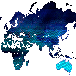
Ten produkt zawiera metadane dotyczące obserwacji, które zostały wykorzystane do obliczenia zbioru danych Global Surface Water. Obszary, na których nigdy nie wykryto wody, są zamaskowane.
Pasma
Rozmiar piksela 30 metrów
Pasma
Nazwa
Minimum
Maks.
Rozmiar piksela
Opis
detections
0*
2007*
metry
Liczba wykryć wody w okresie badania.
valid_obs
0*
2076*
metry
Liczba prawidłowych obserwacji w okresie badania.
total_obs
0*
2417*
metry
Łączna liczba dostępnych obserwacji (czyli scen) w okresie badania.
* szacowana wartość minimalna lub maksymalna
Warunki korzystania z usługi
Wszystkie dane są tworzone w ramach programu Copernicus i udostępniane bezpłatnie, bez ograniczeń dotyczących ich wykorzystania. Pełne informacje o licencji znajdziesz w rozporządzeniu Copernicus.
Publikacje, modele i usługi danych, które korzystają z tych zbiorów danych, muszą zawierać odpowiednie podziękowania, w tym cytowanie zbiorów danych i artykułu w czasopiśmie, jak w tym przykładzie:
Jeśli używasz danych jako warstwy na opublikowanej mapie, podaj ten tekst z atrybucją: „Źródło: EC JRC/Google”.
Cytaty
Cytowania:
Jean-Francois Pekel, Andrew Cottam, Noel Gorelick, Alan S. Belward, High-resolution mapping of global surface water and its long-term changes (Mapowanie w wysokiej rozdzielczości globalnych wód powierzchniowych i ich długoterminowych zmian).
Nature 540, 418-422 (2016). (doi:10.1038/nature20584)
Ten zbiór danych zawiera mapy lokalizacji i rozmieszczenia w czasie wód powierzchniowych w latach 1984–2021 oraz statystyki dotyczące zasięgu i zmian tych wód. Więcej informacji znajdziesz w powiązanym artykule w czasopiśmie: High-resolution mapping of global surface water and its long-term changes (Nature, 2016) i …
[null,null,[],[[["\u003cp\u003eThe JRC Global Surface Water dataset maps the location and temporal distribution of surface water from 1984 to 2021.\u003c/p\u003e\n"],["\u003cp\u003eIt provides statistics on the extent and change of surface water, derived from Landsat 5, 7, and 8 imagery.\u003c/p\u003e\n"],["\u003cp\u003eThe dataset includes metadata about the observations used, including the number of detections, valid observations, and total observations.\u003c/p\u003e\n"],["\u003cp\u003eIt is freely available for use with proper acknowledgment, including citation of the dataset and associated journal article.\u003c/p\u003e\n"],["\u003cp\u003eUsers can explore and analyze this dataset using Google Earth Engine.\u003c/p\u003e\n"]]],[],null,["# JRC Global Surface Water Metadata, v1.4\n\nDataset Availability\n: 1984-03-16T00:00:00Z--2022-01-01T00:00:00Z\n\nDataset Provider\n:\n\n\n [EC JRC / Google](https://global-surface-water.appspot.com)\n\nTags\n:\n[geophysical](/earth-engine/datasets/tags/geophysical) [google](/earth-engine/datasets/tags/google) [jrc](/earth-engine/datasets/tags/jrc) [landsat-derived](/earth-engine/datasets/tags/landsat-derived) [surface](/earth-engine/datasets/tags/surface) [surface-ground-water](/earth-engine/datasets/tags/surface-ground-water) [water](/earth-engine/datasets/tags/water) \n\n#### Description\n\nThis dataset contains maps of the location and temporal\ndistribution of surface water from 1984 to 2021 and provides\nstatistics on the extent and change of those water surfaces.\nFor more information see the associated journal article: [High-resolution\nmapping of global surface water and its long-term changes](https://www.nature.com/nature/journal/v540/n7633/full/nature20584.html)\n(Nature, 2016) and the online\n[Data Users Guide](https://storage.googleapis.com/global-surface-water/downloads_ancillary/DataUsersGuidev2021.pdf).\n\nThese data were generated using 4,716,475 scenes from Landsat\n5, 7, and 8 acquired between 16 March 1984 and 31 December 2021.\nEach pixel was individually classified into water / non-water\nusing an expert system and the results were collated into a monthly\nhistory for the entire time period and two epochs (1984-1999,\n2000-2021) for change detection.\n\nThis product contains metadata about the observations that went into\ncomputing The Global Surface Water dataset. Areas where water has never\nbeen detected are masked.\n\n### Bands\n\n\n**Pixel Size**\n\n30 meters\n\n**Bands**\n\n| Name | Min | Max | Pixel Size | Description |\n|--------------|-----|--------|------------|-------------------------------------------------------------------------------|\n| `detections` | 0\\* | 2007\\* | meters | The number of water detections in the study period. |\n| `valid_obs` | 0\\* | 2076\\* | meters | The number of valid observations in the study period. |\n| `total_obs` | 0\\* | 2417\\* | meters | The total number of available observations (i.e. scenes) in the study period. |\n\n\\* estimated min or max value\n\n### Terms of Use\n\n**Terms of Use**\n\nAll data here is produced under the Copernicus Programme and is provided\nfree of charge, without restriction of use. For the full license\ninformation see the Copernicus Regulation.\n\nPublications, models, and data products that make use of these datasets\nmust include proper acknowledgement, including citing datasets and the\njournal article as in the following citation.\n\nIf you are using the data as a layer in a published map, please include the\nfollowing attribution text: 'Source: EC JRC/Google'\n\n### Citations\n\nCitations:\n\n- Jean-Francois Pekel, Andrew Cottam, Noel Gorelick, Alan S. Belward,\n High-resolution mapping of global surface water and its long-term changes.\n Nature 540, 418-422 (2016). ([doi:10.1038/nature20584](https://doi.org/10.1038/nature20584))\n\n### Explore with Earth Engine\n\n| **Important:** Earth Engine is a platform for petabyte-scale scientific analysis and visualization of geospatial datasets, both for public benefit and for business and government users. Earth Engine is free to use for research, education, and nonprofit use. To get started, please [register for Earth Engine access.](https://console.cloud.google.com/earth-engine)\n\n### Code Editor (JavaScript)\n\n```javascript\nvar dataset = ee.Image('JRC/GSW1_4/Metadata');\n\nvar visualization = {\n bands: ['detections', 'valid_obs', 'total_obs'],\n min: 100.0,\n max: 900.0,\n};\n\nMap.setCenter(71.72, 52.48, 0);\n\nMap.addLayer(dataset, visualization, 'Detections/Observations');\n```\n[Open in Code Editor](https://code.earthengine.google.com/?scriptPath=Examples:Datasets/JRC/JRC_GSW1_4_Metadata) \n[JRC Global Surface Water Metadata, v1.4](/earth-engine/datasets/catalog/JRC_GSW1_4_Metadata) \nThis dataset contains maps of the location and temporal distribution of surface water from 1984 to 2021 and provides statistics on the extent and change of those water surfaces. For more information see the associated journal article: High-resolution mapping of global surface water and its long-term changes (Nature, 2016) and ... \nJRC/GSW1_4/Metadata, geophysical,google,jrc,landsat-derived,surface,surface-ground-water,water \n1984-03-16T00:00:00Z/2022-01-01T00:00:00Z \n-90 -180 90 180 \nGoogle Earth Engine \nhttps://developers.google.com/earth-engine/datasets\n\n- [](https://doi.org/https://global-surface-water.appspot.com)\n- [](https://doi.org/https://developers.google.com/earth-engine/datasets/catalog/JRC_GSW1_4_Metadata)"]]