- در دسترس بودن مجموعه دادهها
- ۱۹۷۲-۰۷-۲۵T۰۰:۰۰:۰۰Z–۱۹۸۳-۰۲-۲۰T۰۰:۰۰:۰۰Z
- تولیدکننده مجموعه داده
- سازمان زمینشناسی آمریکا (USGS)
- برچسبها
توضیحات
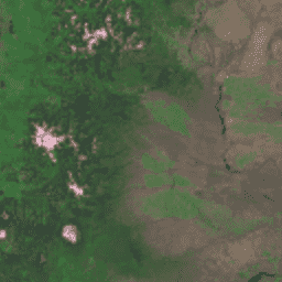
نقشهبرداری جهانی زمین (GLS) 1975 مجموعهای جهانی از تصاویر اسکنر چندطیفی لندست (MSS) است. بیشتر صحنهها توسط لندست 1-3 در سالهای 1972-1983 گرفته شدهاند. چند جای خالی در دادههای لندست 1-3 با صحنههایی که توسط لندست 4-5 در سالهای 1982-1987 گرفته شدهاند، پر شده است. این دادهها شامل 4 باند طیفی هستند: سبز، قرمز، یک باند NIR و یک باند SWIR. در نمایش معمول رنگ کاذب، تصاویر قرمز به نظر میرسند زیرا باند NIR که به صورت قرمز نمایش داده میشود، پوشش گیاهی را برجسته میکند.
باندها
باندها
اندازه پیکسل: ۶۰ متر (همه باندها)
| نام | اندازه پیکسل | طول موج | توضیحات |
|---|---|---|---|
10 | ۶۰ متر | ۵۰۰-۶۰۰ نانومتر | سبز |
20 | ۶۰ متر | ۶۰۰-۷۰۰ نانومتر | قرمز |
30 | ۶۰ متر | ۷۰۰-۸۰۰ نانومتر | نزدیک به مادون قرمز |
40 | ۶۰ متر | ۸۰۰-۱۱۰۰ نانومتر | مادون قرمز با طول موج کوتاه |
شرایط استفاده
شرایط استفاده
مجموعه دادههای لندست، دادههایی هستند که توسط دولت فدرال ایجاد شدهاند و بنابراین در مالکیت عمومی قرار دارند و میتوانند بدون محدودیت حق نشر، مورد استفاده، انتقال یا تکثیر قرار گیرند.
قدردانی یا اعتبار USGS به عنوان منبع دادهها باید با درج یک سطر از متن استناد، مانند مثال نشان داده شده در زیر، ارائه شود.
(نام محصول، تصویر، عکس، یا مجموعه داده) با اجازه سازمان زمینشناسی ایالات متحده
مثال: تصویر لندست-۷ با حسن نیت از سازمان زمینشناسی ایالات متحده
برای جزئیات بیشتر در مورد استناد صحیح و تأیید محصولات USGS، به راهنمای سیستم هویت بصری USGS مراجعه کنید.
نقل قولها
تصویر GLS 1975 با حسن نیت از سازمان زمین شناسی ایالات متحده
با موتور زمین کاوش کنید
ویرایشگر کد (جاوااسکریپت)
var dataset = ee.ImageCollection('LANDSAT/GLS1975');
var falseColor = dataset.select(['30', '20', '10']);
var falseColorVis = {
  gamma: 1.6,
};
Map.setCenter(44.517, 25.998, 5);
Map.addLayer(falseColor, falseColorVis, 'False Color');